I call that playing Peek a booYeah, cause Jeff was brown-capping too.

I call that playing Peek a booYeah, cause Jeff was brown-capping too.
I deleted that post. I'm sorry Jeff, I could not resist with the topic.In retrospect, that wasn’t very nice of me.
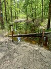
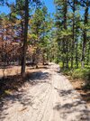
Does anyone know exactly what the whips are called? It would be interesting to add up the cost of them including the stickers plastered on them. A bollard like that is in the $35 range for each one. They must have spent thousands of dollars on them. And many of them have melted in fires or have been snapped off at the base and have been replaced. And stolen.I currently have a site for the night at Hawkins Bridge CG. Walking from the CG to the bridge, the brown plastic whips are rampant.....
Update. A carsonite trail post. These are similar but not exact. Other sites have the exact ones. If they buy 300 it is over $6000 without the stickers.Does anyone know exactly what the whips are called? It would be interesting to add up the cost of them including the stickers plastered on them. A bollard like that is in the $35 range for each one. They must have spent thousands of dollars on them. And many of them have melted in fires or have been snapped off at the base and have been replaced. And stolen.
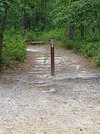
They are literally turning Wharton into some sort of theme park with all of the crowd control features. Should we expect velvet rope and posts soon to guide the general public to wait to enter points of interest? Tickets please!
I think they junk up the forest and look awful, and they continue to pop everywhere each week in a never ending way. "no horses, no bicycles, no motor vehicles, foot traffic only, monitoring cameras in use" makes me sick seeing them at every glance. In fact I get the same feeling seeing them that I feel when I see trash left out there. Many of the roads blocked are also in great condition, do not run through or invade sensitive areas and do not accumulate water or water damage. Why close all of the roads near the Carranza memorial, Hawkins turnpike just to name a few etc? I would love to know what studies were done as well as see the reason for every single road that was closed. We don't see it because, there are no studies and real reasons outside of the agenda of a few people (3) and we all know who they are.
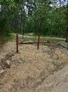
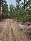
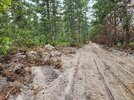
The other thing I would like to know... in what universe is it that closing roads is the best idea for fire control and accessibility. (obviously roads work as a barrier and you cant help but notice in the attached picture) I know this is one of the no brainer points brought up over and over but it highlights the hypocrisy of it all. They went and DESTROYED Washington Turnpike and Forge/Oswego road with a 30 foot path of destruction on each side and massive tree thinning with no regard for what they are trying to protect to create a fire barrier. Once those closed roads (serving as fire barriers) grow in, they are never coming back. I would love to see studies on how closing these roads impacts fire control vs allowing the public to keep them open. What is the first thing that is done to control a fire where there is no road... they create a barrier with a fire cut so how is a 12-15 foot wide road a detriment? In addition, as I have said before, I barely see a single other person out there when you stray away from the campgrounds and typical canoe drop offs that Pinelands Adventures and the other companies use. Where is this huge problem, where is the traffic and usage data for that? Who from Trenton came down to visit and ride around to so see exactly what I am stating. No one did...they took the word of those with an agenda and crying in their ear at every single DEP meeting. I would like to see the number of people that were actually traveling what are now the closed roads... it will be minimal at best and definitely not worthy of making it a crime scene to do so.
As they correctly indicate, those topo maps range from about 25 years to 70 years old and no longer reflect reality on the ground. Have posted about this before, and I'm sure we could find many other examples, but here is one.
Bulldozed Road is on the USGS National Map
https://boydsmaps.com/#15.00/39.734405/-74.650742/ustopo2023/0.00/0.00
OpenStreetMap
https://boydsmaps.com/#15.00/39.732854/-74.653489/usopentopo/0.00/0.00
Clearly visible on aerial imagery
https://boydsmaps.com/#17.00/39.732854/-74.653489/nj2020/0.00/0.00
But not on the old 24k topo, so I guess it would be closed
https://boydsmaps.com/#15.00/39.733387/-74.654245/legacy24k/0.00/0.00
That's a nice catch Boyd. But really, we all supported Ben's open letter back in 2016 (snippet below). To me, it's important the members of the forum support that letter and the contents, even if it sacrifices roads under the radar such as that one.
NJPineBarrens.com and Open Trails NJ are taking the position that:
- We support using a USGS Topographical map to establish a baseline of roads, however the 1997 map must be used as it is last complete map of roads in Wharton State Forest.