Will the real Pinelands please stand up.

46er

Piney
Mar 24, 2004
8,837
2,143
Coastal NJ
There are 2 boundaries defined, fed and state, with no reason I can find. How come?

From the NPS web site

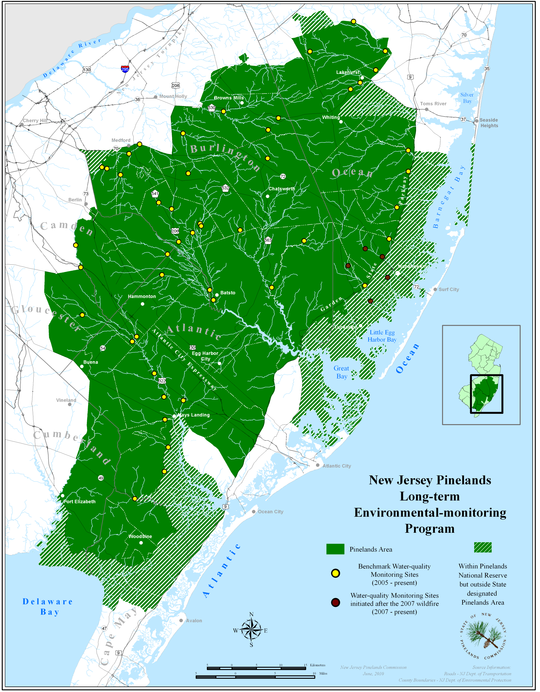
The boundaries of the Federal Pinelands National Reserve and the Pinelands Area, as defined by the state legislation, differ somewhat. The Reserve, totaling 1.1 million acres, includes land east of the Garden State Parkway and to the south bordering Delaware Bay, which is omitted from the 927,000 acre state Pinelands Area. The two jurisdictions together cover all or parts of 56 municipalities spread across seven counties -- Atlantic, Burlington, Camden, Cape May, Cumberland, Gloucester, and Ocean.

WebPageMaps_PinelandsWideWQ_reduced.png
 

manumuskin

Piney
Jul 20, 2003
8,552
2,465
59
millville nj
www.youtube.com
Down my way I can show you areas that are more barrens outside their designated area then whats in their designated area.Areas that have no protection whatsoever.Millville and Vineland both set on Cohansey Aquifer and wherever the woods have not been disturbed with earth moving machines and are still woods they are barrens.The woods and swamps mostly look barrens all the way to the Cohansey except closer to the Bay where it turns more maritime forest.
 

46er

Piney
Mar 24, 2004
8,837
2,143
Coastal NJ
Those striped eastern sections above AC are wall to wall housing with NWR thrown in here and there, except for IBSP which is dune to maritime. I think oji hit the nail on the head; no science, just politics.
 

Gibby

Piney
Apr 4, 2011
1,640
442
Trenton
It does indicate certain complexes within the fed boundary are not treated the same as Pinelands, so why include them?

I'm not sure of this but didn't Governor Byrne designate the core of the barrens as the preservation area and the surrounding lands the protection area? I think if we looked into the wording of the 1979 Pinelands Protection Act and what is in the CMP we could find an answer.
 

46er

Piney
Mar 24, 2004
8,837
2,143
Coastal NJ
They may have realized it would be futile to enact regulations in the fed area's outside of the state boundary due to how highly developed it is.
 

joc

Explorer
May 27, 2010
187
19
Wall, NJ
Down my way I can show you areas that are more barrens outside their designated area then whats in their designated area.Areas that have no protection whatsoever.Millville and Vineland both set on Cohansey Aquifer and wherever the woods have not been disturbed with earth moving machines and are still woods they are barrens.The woods and swamps mostly look barrens all the way to the Cohansey except closer to the Bay where it turns more maritime forest.

Agree 100 % ! Further to above post Any one have any idea why Southern Monmouth is/ has always been excluded , yet so very similar? Its' obviously built up , but the Pines seem to extend a bit in to Southern Monmouth ....Allaire , Shark River , etc are very similar soil , topography , flora ...
 
  • Like
Reactions: manumuskin

Boyd

Administrator
Staff member
Site Administrator
Jul 31, 2004
9,502
2,765
Ben's Branch, Stephen Creek
Howard Boyd examines this in his book "The Ecological Pine Barrens of New Jersey". See the map on page 5 where he shows the pine barrens boundaries based on his ecological criteria. He shows it going North of Freehold with an outlier in the Spotswood area. I would love to post a scan of the map, but it's copyrighted. ;)
 
  • Like
Reactions: joc

joc

Explorer
May 27, 2010
187
19
Wall, NJ
Howard Boyd examines this in his book "The Ecological Pine Barrens of New Jersey". See the map on page 5 where he shows the pine barrens boundaries based on his ecological criteria. He shows it going North of Freehold with an outlier in the Spotswood area. I would love to post a scan of the map, but it's copyrighted. ;)
Thanks Boyd !
 
Top