Working with Waypoints and Maps

bobpbx

Piney
Staff member
Oct 25, 2002
14,659
4,836
Pines; Bamber area
Boyd, I'm reading your help section and trying to understand the workings of waypoints. A couple of things I want to bring up. Don't think of them as critiques, it's just maybe I'm not seeing or understanding something. I'm trying to use your site more since it's so useful to what I do.

1) You say in the help section that: "The boydsmaps waypoint format has more options and fewer rules than Garmin. You can create waypoints with no name, for example so that only the icon will be shown on the map."

But in BaseCamp, Garmin will allow you to only show the waypoint on the map if you want, but still keep the names. I don't think your waypoint spreadsheet allows that? Seems if I delete the name in the editor to only show the symbol, it's gone forever?

2) If I have, say, 15 flag symbols on the spreadsheet, and I want to change them all to a round orange circle, I still have to change them one at a time? Usually in a spread sheet there is a copy-paste function to quickly change them all.

3) Different topic; topo maps, and this is just in case you make future changes and are in the mood. I realize in the USGS 24K legacy topos, you had to be selective in choosing based on several factors, but this contrast between the one on the left and the one on the right is striking. I keep looking at the left map and wishing I was actively in that one on the site I'm surveying because I know my presentation will be much better when I submit the map showing the waypoints. The years presented mean little to me as long as they are past 1949 and the contrast is good. Another thing; when I submit the map, I'd love to be able to cite the year and quadrant of the map (ex. "1957 topo map by USGS, Woodmansie NJ Quadrangle, 7.5 minute series.").

1689529332278.png
 

Boyd

Administrator
Staff member
Site Administrator
Jul 31, 2004
9,826
3,005
Ben's Branch, Stephen Creek
But in BaseCamp, Garmin will allow you to only show the waypoint on the map if you want, but still keep the names. I don't think your waypoint spreadsheet allows that? Seems if I delete the name in the editor to only show the symbol, it's gone forever?

I just tried and didn't have that problem. I created a couple new waypoints, then clicked one on the map which opened the edit window. I deleted the name and then clicked the save button. For the other, just to check, I selected the point in the spreadsheet and clicked the edit button, then did the same thing. In both cases, the waypoints remain on the map but if you click to edit them, the name field is blank. Not sure what to say, you may have discovered some bug that only occurs under certain circumstances?

But I didn't really expect this to be a common feature, just gave it as one example of something that was possible. Yes, I considered adding a feature in the editor to show or hide the waypoint. Didn't implement it because it was just more code to write and also because I thought it could be confusing not to see some waypoints.

2) If I have, say, 15 flag symbols on the spreadsheet, and I want to change them all to a round orange circle, I still have to change them one at a time? Usually in a spread sheet there is a copy-paste function to quickly change them all.

Yeah, that would be nice. Lots of additional features would also be nice to have. It looks like a spreadsheet, but it's actually all new hand-written code. Takes a lot of work to implement things and this is the first post in two years that suggests anyone even uses the existing features!

Don't get me wrong, I don't mind your comments and suggestions at all, actually they're great! I agree the waypoint features could be improved. But the issue is just one of time and priorities for me. I write all the code, make all the maps, administer the server... I have to budget my time and spend it where I think best. And I concentrate on the things that interest me the most and (unfortunately for you in this case) waypoints just don't interest me much. I wanted to add basic waypoint functionality and think I did that, it's unlikely that I will be adding any new features for waypoints. Sorry.

3) Different topic; topo maps, and this is just in case you make future changes and are in the mood. I realize in the USGS 24K legacy topos, you had to be selective in choosing based on several factors, but this contrast between the one on the left and the one on the right is striking

Yeah, there are some quads in the Pines that could be better. I may selectively replace some eventually, but no promises as to when. Keep in mind, there are about 7,500 quads in that map. For each quad, I might review 3 or 4 different versions from the USGS server so I've looked at (literally) thousands while creating the map. Some of them just didn't get the attention they deserved. I realize the Pines are your area of interest, this is NJPB and the Pines are also my home and area of interest. But that's about 100 quads out of 7500 and my focus is now extending that map to a larger area in the future. I think there are already a wealth of resources on my site for the Pines, but of course that doesn't mean there isn't room for improvement.

The years presented mean little to me as long as they are past 1949 and the contrast is good. Another thing; when I submit the map, I'd love to be able to cite the year and quadrant of the map (ex. "1957 topo map by USGS, Woodmansie NJ Quadrangle, 7.5 minute series.").

I understand your desires, but the theme of that map is offering the newest version of each quad. That might mean choosing one that is less "pretty" sometimes. Sometimes the quality is so low that I do use older versions however. It gets difficult, because the dates on the quads don't seem to necessarily reflect their most recent revision. USGS has a pretty confusing naming system.

Like I said, there are 7500 quads, I don't think it's practical to just publish that as a list. However, I was actually thinking about this issue recently. It would be possible for me to create a system where the quad name is displayed like I do with the geodata in the PinesXT app. That would involve some new code and maps to roll it into the main boydsmaps app, not sure when/if this might happen but I have considered it.

In the meantime, I'm posting the info on all the New Jersey quads below (quad name, year and USGS filename), that may help you out in the meantime. Sorry, this is all of NJ, there is no easy way for me to separate South/North. Might also be a couple missing quads that are actually identified as Pennsylvania.
 
Last edited:

bobpbx

Piney
Staff member
Oct 25, 2002
14,659
4,836
Pines; Bamber area
Thanks for the replies, and thanks for the list too. I don't need the info on your map now, as I do have one of those block sheets that overlay the quads onto a NJ outline map and I can easily figure out the name, I was just stuck on the year.

To be clear, that list corresponds to what's in the USGS 24K legacy topos, right?
 

Boyd

Administrator
Staff member
Site Administrator
Jul 31, 2004
9,826
3,005
Ben's Branch, Stephen Creek
Yes, that's a printout of the database I created when downloading the maps and those are the actual files used. Only exception might be the names that end with "OE" - such as Sea Isle City OE E.

Those quads were an interesting puzzle for me, the names are in the USGS shapefiles that show quad locations, but they aren't available to download. However, the new digital versions are available and that is what I initially used. After working my way up and down the coast for awhile, I realized that these small maps are almost always included on an adjacent quad, which might be a little larger than usual. That didn't fit easily into my system of slicing and dicing the map into quads, so in the end, I went back and dealt with them individually, manually cropping and georeferencing them.
 
  • Like
Reactions: bobpbx

bobpbx

Piney
Staff member
Oct 25, 2002
14,659
4,836
Pines; Bamber area
Also, to be clear, you said about the waypoints:

"But I didn't really expect this to be a common feature, just gave it as one example of something that was possible. Yes, I considered adding a feature in the editor to show or hide the waypoint"

I meant to show or hide the "names" on the map, not the waypoints (you maybe just did a typo?). I will always need the waypoints, but forcing the map to not show the waypoint names allows me to unclutter the map in certain instances. Often the names get in the way of seeing other waypoints and the topography. See below, from Basecamp with names on (and that hides some of the land) and off. When they are off I can also use word to insert other information.

Names on:
1689535010294.png


Names off:
1689535215273.png
 

Boyd

Administrator
Staff member
Site Administrator
Jul 31, 2004
9,826
3,005
Ben's Branch, Stephen Creek
Yes, I understood but just wasn't clear in the response. There's just no way to hide the waypoint names in my app. You can create a waypoint with no name which will display the point only. If you do that, you could put the name in one of the other fields, so it would show in the spreadsheet but not on the map.

I understand what you are trying to do, but my app just can't do it and that's not likely to change anytime soon. Sorry.
 

bobpbx

Piney
Staff member
Oct 25, 2002
14,659
4,836
Pines; Bamber area
Yes, I understood but just wasn't clear in the response. There's just no way to hide the waypoint names in my app. You can create a waypoint with no name which will display the point only. If you do that, you could put the name in one of the other fields, so it would show in the spreadsheet but not on the map.

I understand what you are trying to do, but my app just can't do it and that's not likely to change anytime soon. Sorry.
I like your suggestion to put the name in another field temporarily. That'll work.
 
  • Like
Reactions: Boyd

bobpbx

Piney
Staff member
Oct 25, 2002
14,659
4,836
Pines; Bamber area
By the way, forget what I said about not caring what year the map is. This 2014 Westcreek map (on the right), is really lame compared to the same quad on your site.

1689537115375.png
 
  • Like
Reactions: Boyd

Boyd

Administrator
Staff member
Site Administrator
Jul 31, 2004
9,826
3,005
Ben's Branch, Stephen Creek
Sure, those are the new digital topo maps, USGS calls them "US Topo". They are a completely different animal. The only places where I used those are where no legacy topo exists, and all of those places are outside of New Jersey.
 

RednekF350

Piney
Feb 20, 2004
5,054
3,327
Pestletown, N.J.
What USGS has to the 7.5 minute quad sheets is almost criminal.

I tell our draftsmen when they inserting key maps onto my surveys and other mappings to only use the old quads. We have a very good library of old 7.5 minute paper maps and I just scan at high resolution and then they can import on that into CAD.
 
  • Like
Reactions: Boyd

Boyd

Administrator
Staff member
Site Administrator
Jul 31, 2004
9,826
3,005
Ben's Branch, Stephen Creek
  • Like
Reactions: RednekF350

bobpbx

Piney
Staff member
Oct 25, 2002
14,659
4,836
Pines; Bamber area
Boyd, is it possible for you to extend the waypoint location info on the main page to 5 digits? That would be more aligned with my plant labels and state points. Sometimes I forget to capture a waypoint on my GPS and so use your map to see what it was by going to the same spot.

1701362096798.png
 

Boyd

Administrator
Staff member
Site Administrator
Jul 31, 2004
9,826
3,005
Ben's Branch, Stephen Creek
Yeah, I think it used to be 6 and I shortened it because it won't fit on a phone screen (that part of my code is the same for both the mobile and desktop versions). 4 digits is around 30 ft precision, 6 digits is something like 3 inches - unless you're using special equipment that costs thousands of dollars, that's overkill. Are you recording 6 digit coordinates in the field?

If you click the "globe" button in my app, it will show your current position with 6 digits and you can also enter six-digit coordinates there. But I can have another look at this, would like to update some of that code anyway. Might be awhile before I get around to it though.
 

bobpbx

Piney
Staff member
Oct 25, 2002
14,659
4,836
Pines; Bamber area
Yeah, I think it used to be 6 and I shortened it because it won't fit on a phone screen (that part of my code is the same for both the mobile and desktop versions). 4 digits is around 30 ft precision, 6 digits is something like 3 inches - unless you're using special equipment that costs thousands of dollars, that's overkill. Are you recording 6 digit coordinates in the field?

If you click the "globe" button in my app, it will show your current position with 6 digits and you can also enter six-digit coordinates there. But I can have another look at this, would like to update some of that code anyway. Might be awhile before I get around to it though.
I asked for 5, does that make a difference?

Edit: just saw your click on the globe suggestion to see 5 or 6. That's fine, I can do that.
 
  • Like
Reactions: Boyd

Boyd

Administrator
Staff member
Site Administrator
Jul 31, 2004
9,826
3,005
Ben's Branch, Stephen Creek
5 digits would certainly be as accurate as any GPS you're likely to find. For me, either 4 or 6 digits were the options I have considered. Either way, it would involve changing some code so the mobile and desktop versions have a different number of digits.
 

bobpbx

Piney
Staff member
Oct 25, 2002
14,659
4,836
Pines; Bamber area
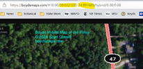
I just realized Boyd, that if I simply look a the browser adress, it portrays them to 6 digits. Duh.
1715788777441.png
 

Attachments

  • 1715788712802.png
    1715788712802.png
    388.5 KB · Views: 61
  • Like
Reactions: Boyd

Boyd

Administrator
Staff member
Site Administrator
Jul 31, 2004
9,826
3,005
Ben's Branch, Stephen Creek
Yes, I use six digits for internal purposes. I only reduced it to four in the title bar because the long numbers don't fit on small screens.
 
Top