This post gets more interesting all the time.As Scott mentioned,a ton of history in a square mile.Did not know about the dam and lake.When I first got acquainted with that area[Batsto]a lot of people lived there.That was when it was the Wharton Estate.When the State bought the Estate,I believe the people were ordered to move,along with many deer clubs and the people that lived at Hampton Furnace.Thanks for posting the pictures ,Scott.

In Search Of: Y-Buc Bridge
- Thread starter RednekF350
- Start date
You are using an out of date browser. It may not display this or other websites correctly.
You should upgrade or use an alternative browser.
You should upgrade or use an alternative browser.
'Twas a jolly time yesterday roaming the woods with RednekF350 and his zesty pup, Murphy.
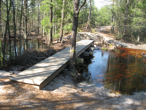
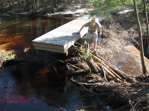
Sadly, I discovered that a significant portion of the remaining ruins of what was likely Joseph Ball's dam (1780's) was recently removed along with the beaver dam that recently stretched the stream at this point. The ruins can be seen in Y-Buc's photo in the opening post of this thread. Another case of the one hand not knowing what the other is doing? Or just another example of the apathy of the State towards its own history?

Sadly, I discovered that a significant portion of the remaining ruins of what was likely Joseph Ball's dam (1780's) was recently removed along with the beaver dam that recently stretched the stream at this point. The ruins can be seen in Y-Buc's photo in the opening post of this thread. Another case of the one hand not knowing what the other is doing? Or just another example of the apathy of the State towards its own history?
You are a true pioneer Bill. My hats off to you. Looked like you were having a great time too.
My father ran motorcyles in some type of races in the late 40's early 50's up around the Metuchen area. He died when I was 3 years old, so I have no memory of him at all, but one of us kids has a photo of him with his bike.
My father ran motorcyles in some type of races in the late 40's early 50's up around the Metuchen area. He died when I was 3 years old, so I have no memory of him at all, but one of us kids has a photo of him with his bike.
Very interesting thread! This too, hits close to home for me. I love finding those "then and now" places.
Its sad to hear that they removed the beaver dam, and a large chunk of the old ruins there. Heres two pictures (I might be able to dig up more) from this past April (26th), showing the bridge in mid-construction. A portion of the beaver dam was still around at this time.
http://www.flickr.com/photos/22516573@N07/3537415985
Larger Photo: http://farm4.static.flickr.com/3305/3537415985_765dc24ba6_b.jpg
Larger Photo: http://farm3.static.flickr.com/2101/3537419055_b6724eacd5_b.jpg
'
Sadly, I discovered that a significant portion of the remaining ruins of what was likely Joseph Ball's dam (1780's) was recently removed along with the beaver dam that recently stretched the stream at this point. The ruins can be seen in Y-Buc's photo in the opening post of this thread. Another case of the one hand not knowing what the other is doing? Or just another example of the apathy of the State towards its own history?
You are referring to the location we were at on our kayak trip?
Guy
You are referring to the location we were at on our kayak trip?
Guy
No, not New Pond Dam on Atsion Creek, but Ball's Folly, which is just up the Mechescatauxin from there.
bobpbx....What was your Dad's name.? Did he ride Enduro's?.I knew some riders from that area.
Bill, he was an ex-marine, and his name was Robert Linde Poulson (Bobby). I have a dim memory of someone telling me he was also one of those guys who rode his motorcycle on the walls in a big barrel. I really don't know if he did woods riding or not.
I've asked my sister for the photo.
Great thread. I can see now how the canal was quite a bit upstream from the area of the bridge. Amazing how different the landscape was from the time Bill was riding there and present day. But considering the loss of the lake and the 60 years between...maybe not so surprising.
A shame about the old dam ruins Gabe. They were removed professionally I presume from your post? It seems the state would have had an archeologist at hand before conducting such work, but I guess someone dropped the ball (no pun intended). did you get a chance to see the ruins before they were removed? I don't recall ever seeing them, though I was there before.
Jeff
Well, I'm going to have to back down off this for now, because the ruins depicted in Y-Buc's photo may have already been destroyed by the State in the 50's when they built the first footbridge there. I took Budd back there yesterday, and he concluded that we do not have a case, not yet at least. What I really need to see is another picture of the spot in question from recent times to see if I can spot the specific ruins that I remember.
@Teegate Guy, what do those two arrows point to?Great report and exploring!
Are you sure Bill was crossing a stream and not the canal? Notice in the below map there was a road that crossed the canal back then. The crossing where Bill is at is not as wide as the where the bridge is, but it is about the width of the canal. The map shows a bridge over the canal, and it could be what is shown in Bill's photo.

Guy
First, let's start with the lower arrow. It points to two circles that overlap each other. The lower one is the center of the stream and the upper one is the NJ1M Wharton Monument on the north side of the stream. The arrow above points to the distance between the upper monument (NJ2M) and the lower monument mentioned above (110.67 feet). And if you look closely right at the top of the blue circle you can see the small circle for the NJ3M Wharton monument.
Jessica and I visited the area's in question today and it was our first in most of the places. I am not a Batsto or Batsto area lover because we try to stay away from running into people. In any event, we walked almost three miles across both bridges and explored the dunes beyond. In one of the dunes I was surprised to find this monument. It is a Wharton monument with nothing stamped into it and I have no information on it. Since it is farther in the woods in an area where the Wharton property at the time was minimal, it most likely was a State Plane Coordinate monument that the surveyors used to help them find the Wharton property corners nearby.
I am still at times surprised with new Wharton monuments that I know nothing about.
BTW, it is located in a dune across the metal bridge.

I am still at times surprised with new Wharton monuments that I know nothing about.
BTW, it is located in a dune across the metal bridge.
The thing that fascinates me the most about that spot is the work it took to dam the both the Mullica River and the Sleeper Branch back in the early part of the 1900's. Everything was intact in the 1930 aerial.
Guy, we talked about this many moons ago: https://forums.njpinebarrens.com/threads/marker-near-batsto.1435/Jessica and I visited the area's in question today and it was our first in most of the places. I am not a Batsto or Batsto area lover because we try to stay away from running into people. In any event, we walked almost three miles across both bridges and explored the dunes beyond. In one of the dunes I was surprised to find this monument. It is a Wharton monument with nothing stamped into it and I have no information on it. Since it is farther in the woods in an area where the Wharton property at the time was minimal, it most likely was a State Plane Coordinate monument that the surveyors used to help them find the Wharton property corners nearby.
I am still at times surprised with new Wharton monuments that I know nothing about.
BTW, it is located in a dune across the metal bridge.
View attachment 21042
I don't remember that but obviously I responded to it. Thanks for reminding me. The link no longer works. I find it odd that I did not go right out and look for it back then.
That is a Wharton marker so it is from the Wharton survey in the 50s. The numbers did not wear off, they for some reason did not stamp anything on it. It is only the second one I have found that they did not even document.
That is a Wharton marker so it is from the Wharton survey in the 50s. The numbers did not wear off, they for some reason did not stamp anything on it. It is only the second one I have found that they did not even document.
Hi Guy. Apologies for the slightly off topic question, but it doesn't seem to merit a new thread: is there any available digital copies of the 1950s Wharton survey?I don't remember that but obviously I responded to it. Thanks for reminding me. The link no longer works. I find it odd that I did not go right out and look for it back then.
That is a Wharton marker so it is from the Wharton survey in the 50s. The numbers did not wear off, they for some reason did not stamp anything on it. It is only the second one I have found that they did not even document.
No there is not. Sorry.Hi Guy. Apologies for the slightly off topic question, but it doesn't seem to merit a new thread: is there any available digital copies of the 1950s Wharton survey?
Years back I remember seeing a photo looking at the dam from downstream. I was impressed with the amount of lumber used for that dam. I don’t remember where I saw it but I thought it was on one of the threads here.The thing that fascinates me the most about that spot is the work it took to dam the both the Mullica River and the Sleeper Branch back in the early part of the 1900's. Everything was intact in the 1930 aerial.