Took the wife and kids for a ride to the mountain on Saturday. We came in from the direction of 539 via Bryant Rd. Once I got to the base of the mountain before you turn right and go up I noticed the road toward the railroad had been cut and widened on both sides. I did not follow it so I dont know how far it goes, possibly all the way to Lacey Road? Not sure what the plans are from the county, does anyone else know anything? They thinned out the smaller trees around the bigger ones. I was out there last weekend and it was not like that. Here is a picture at the base of the mountain looking towards the railroad/north

More Changes at Forked River Mountain
- Thread starter Wick
- Start date
You are using an out of date browser. It may not display this or other websites correctly.
You should upgrade or use an alternative browser.
You should upgrade or use an alternative browser.
I don't think that has anything to do do with the county, but the FFS. I'm sure they [FFS] asked the county for permission. The FFS did the same in Warren Grove a couple of years ago to Red rd [Stephenson] and Beaver Dam rd. It's a type of firebreak in the event of a forest fire. After the Warren Grove fire that burned into the trailer park, they really did a clearcut along Recovery rd to the dump. I would not be surprised to see this done to more of the main roads. I would also expect to see a multitude of new fire cuts throughout the new county park. The entire area has been lacking fire control since.......forever. I wouldn't be surprised if work is done from Jones rd all the way to Lacey Materials. You said the road from the back of the pit to the RR grade has been widened and improved?
Yes the road from the materials to the railroad and the railbed behind the materials has been graded but not widened. The road over Frazees bridge was widened. There are now multiple firecuts that go from Lacey rd to the railroad. They used all the trails from materials going towards the railroad as fire breaks too. These trails were always there, but just overgrown. Now you could drive through them with a full size truck. I will try to get out there again this weekend if its not raining
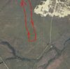
A friend and I (about 6 weeks ago?) walked all the way down one firecut to where it ended, and back up another one. It's a considerable distance. About like this below if I recall.

Yes, that is quite a distance, especially through that soft grey sand. Did you make it to the trail that follows the Forked River? The area that you marked looks kinda of just wooded. Was there any special features? did you hit any parts of the deep hollow branch?
Wow, Bob. really? I haven't been down Lacey rd for some time. I know they burned along Lacey rd and had the road closed. So now there are multiple fire cuts all along Lacey rd extending to approximately your picture? They are huge and long. Find anything interesting? They really are carving up the new park.
Yes, we did in fact dip down into the Deep Hollow Branch on both fire cuts. It's clearly evident when you do, but it was dry. I doubt it would ever have water above ground where we crossed. We also dipped down a tad on the other dry leg of that branch. I think the fire cuts are 500 feet apart. The fire cut ended at the border of what was the Brunetti property, but now County. This border is a decent sized trail. Look at the aerial below. The cross marker sits on the border. We hit that, then moved SW to the next fire cut and back up to Lacey Road. If we had continued SW on the border, we would have hit the trail you mentioned next to the branch of the Forked River.
I have tracks in my GPS, but I'm having trouble getting them into BaseCamp.
I have tracks in my GPS, but I'm having trouble getting them into BaseCamp.
Attachments
Wow, Bob. really? I haven't been down Lacey rd for some time. I know they burned along Lacey rd and had the road closed. So now there are multiple fire cuts all along Lacey rd extending to approximately your picture? They are huge and long. Find anything interesting? They really are carving up the new park.
Yes, they are doing a lot of work. They are proud they got it. It will be a centerpiece of their park system. They are spending a lot of time on a detailed management plan. Word on the street is they "may" allow driving close to the mountain, at least from one side, with parking spaces. The big problem I see is all these fire cuts allow ATV's to enter. These fire cuts were made with a flat blade-like implement on a small dozer, and they later went in after with the cut digger. But I have to tell you, I have concerns. The place really needs hot fires, not those little piddly fires they created. Hell, you could of probably walked through that fire. It only burned about 1" into the duff in most places, and in some places not even that.
One thing I found interesting. As I'm going down the fire cut, I kept seeing little fragments of pyxie moss chopped up by the blade. I'm looking around for clearings, which is what we all think of with pyxie moss. Finding none, I walked into the woods a bit, and notice a leaf sticking up through pine needle litter. I scraped it away, and there was an entire plant under the duff! So that plant can be more ubiquitous than we think in some areas.
By the way, it's not common knowledge, but that area is a Natural Heritage Priority site. There are places that can be classified as pine plains type in that area. This is from the document:
Locational Information
Quad Name: Brookville ; Forked River ; Woodmansie ; Keswick Grove ; Whiting
County: Ocean
Municipality: Lacey Twp ; Ocean Twp ; Manchester Twp ; Barnegat Twp
Description of Site
A few small occurrences of dwarf pine plains (<150 acres) associated with up to 1000+ acres of transitional pine
plains, and several small occurrences of hydric pine plains. Most of the plains are in the vicinity of Forked River
Mountain, near the center of a large fireshed of over 30,000 acres. Within the fireshed are extensive occurrences of pitch pine-scrub oak barrens, other pine barrens and pine-oak forests, pitch pine lowlands, red maple-black gum palustrine forest, and atlantic white cedar palustrine forest.
Boundary Justification
Fireshed limits where most plant community-maintaining wildfires would originate and be contained within, using convenient man-made and natural firebreaks and distribution of flammable pine barren plant communities for management purposes.
Biodiversity Rank B2
The site contains a globally imperiled pine plains natural community.
By the way, it's not common knowledge, but that area is a Natural Heritage Priority site.
You can download a map of all the Natural Heritage Priority Sites here, as either a Shapefile or KML file.

Natural Heritage Priority Sites in New Jersey
Using the Natural Heritage Database, the Office of Natural Lands Management (ONLM) has identified 343 Natural Heritage Priority Sites, representing some of the best remaining habitat for rare species and rare ecological communities in the state. Although the primary focus of these sites is rare...
njogis-newjersey.opendata.arcgis.com
The shapefile should include more info, but you'll need software to open it, such as the free open source qGIS program


You can also zoom into the map and see outlines of the sites and see their names as you move the mouse. Click on the Data tab and you'll see a spreadsheet that shows all the data from the shapefile.
Here's my actual tracks for that day, 2 Feb. It is about 3.5 miles down and back. Lot of walking in soft sand and ruts.

As for a hot fire, I agree. I guess they had to burn when they could. They may burn again in a year or so. The FFS did a burn just before 3/15 on Beaver Dam rd in Warren Grove. That fire was hot, so hot it became a crown fire. It looks exactly like the Spring Hill fire.
I don't think you can blame the fire cuts for ATV's. They have no problem accessing the area previously. I know how you hate fire cuts though.
I don't think you can blame the fire cuts for ATV's. They have no problem accessing the area previously. I know how you hate fire cuts though.
Didn't know if you know this Bob but that pit in this photo is the area that Tom Brown Jr. refers to Hell in his Tracker and Search books.It's the setting for the wild dog attack story of his. If you read it keep quite a few grains of salt handy.A friend and I (about 6 weeks ago?) walked all the way down one firecut to where it ended, and back up another one. It's a considerable distance. About like this below if I recall.
View attachment 13445
I for one don't like it In a few years they will probably close all the roads off and just allow you to walk in there that how the do it a little at a time.
But Tony, really what are you missing? It was private property anyway.
is our tax money being used now if so it should be open to every one not just walkers
Fair enough. What else do you propose should be allowed in there in terms of non-human powered locomotion?
Didn't know if you know this Bob but that pit in this photo is the area that Tom Brown Jr. refers to Hell in his Tracker and Search books.It's the setting for the wild dog attack story of his. If you read it keep quite a few grains of salt handy.
I see that Tom Brown has come up various times on here over the years, mostly years ago. I read a book by him and encountered him only once around 1993 or 95 when he made an appearance at Ramsey Sporting Goods on Rt 4 in NJ. I got the same impression that most or all of u fellers seem to have, namely that he was largely full of beans. I forget the details now but I remember him getting in a Hummer after his talk.
In my days wandering those woods there were no off road vehicles or motorcycles nor did i ever meet a wild dog pack, just the Jersey Devil sometimes, but we were friends. The worst thing that happened to me was when some damn cranberry bog pilot strafed me with bug spray when i was borrowing a few cranberries - but now I'm probably the only guy alive who was strafed by a biplane!
I had an occurance with a pack of wild dogs in the City of Camden some years ago. No contact but I remember thinking "one more thing that'll kill you in this city".I see that Tom Brown has come up various times on here over the years, mostly years ago. I read a book by him and encountered him only once around 1993 or 95 when he made an appearance at Ramsey Sporting Goods on Rt 4 in NJ. I got the same impression that most or all of u fellers seem to have, namely that he was largely full of beans. I forget the details now but I remember him getting in a Hummer after his talk.
In my days wandering those woods there were no off road vehicles or motorcycles nor did i ever meet a wild dog pack, just the Jersey Devil sometimes, but we were friends. The worst thing that happened to me was when some damn cranberry bog pilot strafed me with bug spray when i was borrowing a few cranberries - but now I'm probably the only guy alive who was strafed by a biplane!