Spung???
Yep,
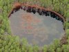
Mudboy Dave’s closed depression is indeed a classic spung. The 1931 aerial photomosaics illustrate the true form of the Ice-Age blowout, its full dimension demarcated by the flying-saucer-shaped darkened patch surrounding the smaller water feature. On the early aerial one can see view cultural activity had occurred upon the southeastern rim, a typical pre- and post-contact land-use characteristic of such basins.
The southeastern rim is often slightly higher and/or somewhat sandier than the surrounding terrain due to deposition of deflated basin sediments – making it a warm, dry place to camp. Also that portion is often downwind of game and so an ideal place to wait in ambush. In the Arctic today the downwind portions of small ponds are less buggy, perhaps an added benefit for spungs too especially in the past.
PinelandPaddler is right, the trail to the southeast is likely very old. I just returned from a NASA International Planetary Dunes Workshop at the Great Sand Dunes National Park in Colorado. Blowouts within the San Luis Valley had similar cultural exploitation going all the way back to the Paleoindians over 13,000 years ago, and in that park they are extensively explored. It’s a shame we know so little about the early cultural dynamics of the Pine Barrens. The Pinelands Commission is more concerned with streamlining and circumventing Comprehensive Management Plan rules than in studying or preserving our wonderful cultural legacy. Cultural resource surveys are now waived left-and-right during major development, or are so loosely applied as to render them useless. I’ve really been disappointed in their stewardship of late.
Spung-Man

") there was just me,Guy and a venerable old black rat snake back there though the roar of Atco was quite noticeable.
there was just me,Guy and a venerable old black rat snake back there though the roar of Atco was quite noticeable.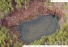


 :jeffd:
