
All:
So, if you haven't read Jerseyman's post on Mary Ann Forge yet, you should read it before you continue on with this post. Done? Great. Let's go.
I decided to take a trip there today. The area around the dam doesn't make a whole lot of sense - so I wanted to try (again) to make heads or tails of it. I found some interesting things while I was out there, but then coming home and re-reading Jerseyman's post and looking at the maps he attached makes me rethink some of my theories. But I'm getting ahead of myself here. I drew a map to help orient us around the dam:

So, about the dam. The dam served two purposes - it held back water on the Mount Misery Run to create a mill pond to power the forge hammers and it also had a road on top. According to the maps that Jerseyman posted, the town spanned both sides of the mill pond. Going down Mount Misery Road from New Lisbon you could either go straight and bypass the town, or swing through town, ride over the bridge, and be back on Mount Misery Road. The dam seems to have been built with a combination of timber and slag, presumably from Hanover Furnace. This is pretty common - there's a dam near Batsto that's built up with slag, and the dam at Martha Furnace also has slag in it.
Here's the millpond.

Here's the dam/road. When you first walk down it you'll come to a dip where it looks to me like the road was undermined by flowing water. The more I think about this, the more I question that theory. (More on that later.)

At this first dip, with your back to the mill pond, there's some sort of channel. I poked around the edge of it by the road and it didn't seem too deep.

On the mill pond side I found two pilings with nails sticking out of them.

Continuing on towards Mount Misery Run there's another channel to your right. It's really grown over with briars here, but I bravely soldiered through them and got to the head of the channel. I thrust my walking stick down and it's pretty deep.

If you keep going you'll get to the river and see where the dam has washed away. You can see some of the pilings from the dam on the opposite bank of the river.

There's a little beachy area that you can walk down and get to the bank of the middle channel. The channel appears straight and narrow, like any good tailrace ought to be.

So I formulated a theory. The channel in the middle HAD to be the tailrace for the forge. It's deep enough at the end to have housed a pit for the mill wheel, and was straight enough to have been made by people and not nature. That leaves the channel closest to town to be explained. Well, I postulated that at some point in time the dam burst there, flooding where the forge was located. The sudden flow of water draining from behind the mill pond would have dug the channel. I was feeling great about that theory until I came home and re-read Jerseyman's post and saw this map:
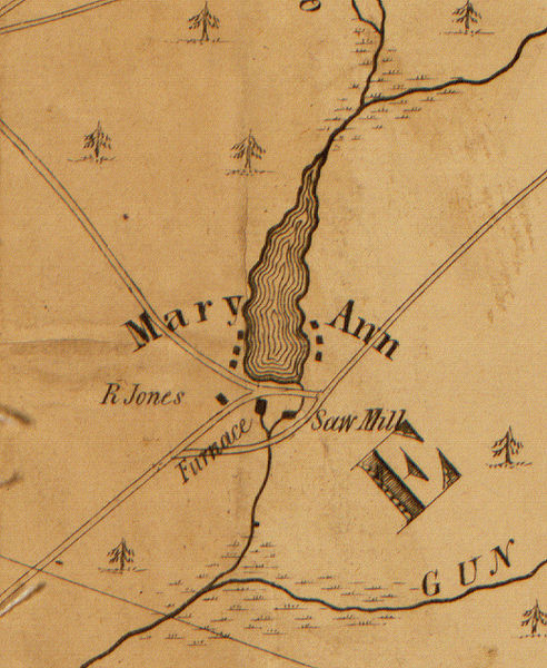
This map clearly shows the raceway for the furnace being the top most channel. Interestingly it also shows a sawmill being powered off of the main channel of the river. Had there been a third channel, I'm confident it would have been included on the map.
Here's the 1930 aerial view. Notice how the middle channel (the deep, straight one) shows up lightly on it:

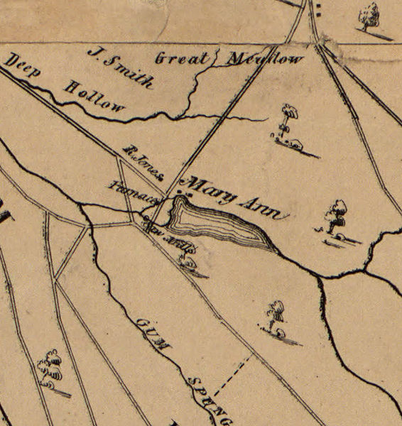
Here again we see the 1858 map showing only two channels:
This place just doesn't seem to make sense. I can't picture them digging two channels (plus the natural course of the river after the dam) since that only leaves a little spit of land to build the forge on.
So, I'm at a loss. I know a lot of folks have been to Mary Ann Forge - what's your take on all of this?
So, if you haven't read Jerseyman's post on Mary Ann Forge yet, you should read it before you continue on with this post. Done? Great. Let's go.
I decided to take a trip there today. The area around the dam doesn't make a whole lot of sense - so I wanted to try (again) to make heads or tails of it. I found some interesting things while I was out there, but then coming home and re-reading Jerseyman's post and looking at the maps he attached makes me rethink some of my theories. But I'm getting ahead of myself here. I drew a map to help orient us around the dam:
So, about the dam. The dam served two purposes - it held back water on the Mount Misery Run to create a mill pond to power the forge hammers and it also had a road on top. According to the maps that Jerseyman posted, the town spanned both sides of the mill pond. Going down Mount Misery Road from New Lisbon you could either go straight and bypass the town, or swing through town, ride over the bridge, and be back on Mount Misery Road. The dam seems to have been built with a combination of timber and slag, presumably from Hanover Furnace. This is pretty common - there's a dam near Batsto that's built up with slag, and the dam at Martha Furnace also has slag in it.
Here's the millpond.
Here's the dam/road. When you first walk down it you'll come to a dip where it looks to me like the road was undermined by flowing water. The more I think about this, the more I question that theory. (More on that later.)
At this first dip, with your back to the mill pond, there's some sort of channel. I poked around the edge of it by the road and it didn't seem too deep.
On the mill pond side I found two pilings with nails sticking out of them.
Continuing on towards Mount Misery Run there's another channel to your right. It's really grown over with briars here, but I bravely soldiered through them and got to the head of the channel. I thrust my walking stick down and it's pretty deep.
If you keep going you'll get to the river and see where the dam has washed away. You can see some of the pilings from the dam on the opposite bank of the river.
There's a little beachy area that you can walk down and get to the bank of the middle channel. The channel appears straight and narrow, like any good tailrace ought to be.
So I formulated a theory. The channel in the middle HAD to be the tailrace for the forge. It's deep enough at the end to have housed a pit for the mill wheel, and was straight enough to have been made by people and not nature. That leaves the channel closest to town to be explained. Well, I postulated that at some point in time the dam burst there, flooding where the forge was located. The sudden flow of water draining from behind the mill pond would have dug the channel. I was feeling great about that theory until I came home and re-read Jerseyman's post and saw this map:
This map clearly shows the raceway for the furnace being the top most channel. Interestingly it also shows a sawmill being powered off of the main channel of the river. Had there been a third channel, I'm confident it would have been included on the map.
Here's the 1930 aerial view. Notice how the middle channel (the deep, straight one) shows up lightly on it:
Here again we see the 1858 map showing only two channels:
This place just doesn't seem to make sense. I can't picture them digging two channels (plus the natural course of the river after the dam) since that only leaves a little spit of land to build the forge on.
So, I'm at a loss. I know a lot of folks have been to Mary Ann Forge - what's your take on all of this?
")


") Ben, I think Gabe's statement here is of extreme importance to understanding the area...there are layers of history literally resting on top of each other in there. tying to decipher what belongs to what operation is difficult. That doesn't mean you should stop tying, I am eager to see what you come up with, but keep this point in mind and see if there are any differences in the construction of the canals that might be indictive of different time periods.
Ben, I think Gabe's statement here is of extreme importance to understanding the area...there are layers of history literally resting on top of each other in there. tying to decipher what belongs to what operation is difficult. That doesn't mean you should stop tying, I am eager to see what you come up with, but keep this point in mind and see if there are any differences in the construction of the canals that might be indictive of different time periods.