1876 map lithos

stizkidz

Piney
May 10, 2003
1,044
8
Tuckerton
Just picked up these 3 map lithographs. These come from the Combination Atlas Map of Salem and Gloucester County by Everts & Stewart, 1876.

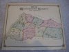
1. Gloucester County (1 sided)
2a. West Deptford, side 1
2b. Deptford, side 2
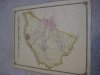
3a. Mantua, side 1
3b. Ewansville, Clarksboro, Jefferson, and Harrisonville, side 2

Thanks for looking.
 

Attachments

  • IMG_2886.JPG
    IMG_2886.JPG
    799 KB · Views: 209
  • IMG_2887.JPG
    IMG_2887.JPG
    793.8 KB · Views: 208
  • IMG_2888.JPG
    IMG_2888.JPG
    732.3 KB · Views: 233

stizkidz

Piney
May 10, 2003
1,044
8
Tuckerton
Too bad Paulsboro is not included in this set but the West Deptford map is definitely my favorite.

It's funny because in a previous post from 2011, I asked about the Moore Farm in Parkeville and in your reply to me, you mentioned the same 1876 atlas. Glad to own such a useful source of information!

Wow! You have a great memory, stizkidz! I would never have recalled that reference. Good to know you are paying attention! :)

Best regards,
Jerseyman
 
Top