abandoned places in wharton

Bobbleton

Explorer
Mar 12, 2004
466
46
NJ
You all know that my forte is rather focused on ecology and wildlife rather than abandoned furnaces and ghost towns and such . . . but its likely that i'll be camping in wharton in the next week or so, and was hoping to supplement my extremely undernourished website with pictures of abandoned places around there. . . I know there are a few but how no clue how to get to them . . .
i'm a rookie in wharton in every aspect . . .
if anyone would be so inclined to pm me some gps coordinates or directions i'd be much appreciative. (nothing super-secret, mind you . . . just normal stuff).

thanks

-Bob
 

Teegate

Administrator
Site Administrator
Sep 17, 2002
26,012
8,788
That is a big area. Can you narrow down where you will be, or don't you care how far you have to travel?

Guy
 

Ben Ruset

Administrator
Site Administrator
Oct 12, 2004
7,619
1,878
Monmouth County
www.benruset.com
The "other" site has a list of GPS coordinates supplied by a former member of this site. So you can cross reference the list below with those.

Wharton Ghost Towns (off the top of my head, and in no particular order)

Atsion
Parkdale
Iron Mill
Quaker Bridge
Mount
Washington
Friendship
Batsto
Hampton Furnace
Hampton Gate (nothing to see there)
Hampton Station (nothing there)
Harrisville (interesting ruins)
Hermann City
Martha's Furnace
Calico
 

Bobbleton

Explorer
Mar 12, 2004
466
46
NJ
Thanks guys . . . and yeah . . . distance isnt' really an issue. In places like wharton (and the pine barrens in general), i usually drive the dirt roads (go hyundai elantra!) to shorten the gap between different ecosystems and places of biological significance. Otherwise i usually find myself staring at a million pitch pines and no herps.

-Bob
 

Teegate

Administrator
Site Administrator
Sep 17, 2002
26,012
8,788
Ben is correct. Joseph Wharton purchased Harrisville in 1896 and paid $29,949.99 for it. If you look at this map you can see where one of multiple sections of the pines acquired as Bass River State Forest is right next to Harrisville. That might be what is causing the confusion. There are many small section even not near there which is considered Bass River. Notice the the last two letter s's at the bottom, and the word River going vertically just to the right of the arrows.


http://mywebpages.comcast.net/teegate/post/wharton.jpg

And Martha was also owned by Wharton, until his death in 1909.


Guy
 

Gerania

Explorer
May 18, 2004
280
30
Marlton
I went out to Martha for the first time the other day. Is there anything other than foliage behind that fence?

Gillian
 

Teegate

Administrator
Site Administrator
Sep 17, 2002
26,012
8,788
Gerania said:
I went out to Martha for the first time the other day. Is there anything other than foliage behind that fence?

Gillian

Did you walk the slag piles along the pond, and go to the river? Did you walk to the bridge?


Guy
 

Gerania

Explorer
May 18, 2004
280
30
Marlton
I stopped at the river on the drive in. I continued to Martha and looked around for just a short time. It was an unplanned stop, (5th of the day) I'd never been there before and it was getting kinda late. I've read that there is a pond out there and that the road eventually leads to a bog. Is that where the bridge is? Saw a newish, nice black pickup with a cap parked on the right 3/4 of the way in. I got out of the car and looked around and listened for a bit but didn't see or hear anyone. Maybe they were looking for Calico.

Was there ever a tavern in the Martha area?

Gillian
 

Teegate

Administrator
Site Administrator
Sep 17, 2002
26,012
8,788
Gerania said:
I stopped at the river on the drive in. I continued to Martha and looked around for just a short time. It was an unplanned stop, (5th of the day) I'd never been there before and it was getting kinda late. I've read that there is a pond out there and that the road eventually leads to a bog. Is that where the bridge is? Saw a newish, nice black pickup with a cap parked on the right 3/4 of the way in. I got out of the car and looked around and listened for a bit but didn't see or hear anyone. Maybe they were looking for Calico.

Was there ever a tavern in the Martha area?

Gillian


The next time you go do this.

Standing at the three way intersection looking at the fence, walk left down the road to the left side of the fence. Cross over the very small stream there and walk into the woods with the fence on your right. This takes you back to the slag piles. It is everywhere on the ground. Climb to the top of the piles and walk left. On your right side is the former Martha pond. Continue on the slag piles and you will come to the river which was dammed years ago to force the water to the furnace at the fence.

If you turn around and head back toward the fence and continue past where you came up the hill, you will see where the water flowed into the furnace behind the fence.

Now go back to the road and continue walking away from the intersection and fence and you will come to the bridge across the river.

Guy
 

Stu

Explorer
Feb 19, 2004
466
3
43
White Haven, PA
www.stuofdoom.com
I went to Calico for the first time today. As I was coming around a turn, someone who was going pretty fast from the other way almost slammed into me. Well, fortunately they veered to their right, and luckily I veered to mine. I figured the kid was gonna start yelling at me (even though he was going pretty fast), but we both started laughing and kept going. It was pretty funny I guess, but it's still not smart to whip around on one lane dirt roads that have quite a few twists & turns.
 

Teegate

Administrator
Site Administrator
Sep 17, 2002
26,012
8,788
That the best way to handle it. Nice!

I almost hit someone over a year ago on a dirt road in the woods. Instead of brushing it off they blocked the road, so after sitting there for a while I drove through the brush and trees and went around them. I always look at it from the point that we all make mistakes, and as long as nobody was hit or hurt, just continue on.

Guy
 

Teegate

Administrator
Site Administrator
Sep 17, 2002
26,012
8,788
I have not been there in a while. Are you sure it is not being used by hunters. Ben and I ran into hunters in that area once with campers.

I did see an abandoned boat on the side of Pasadena road today. I also noticed a bunch of vehicles next to the water tower at Pioneer Smelting. I am wondering if they are going to remove it.

Guy
 

Boyd

Administrator
Staff member
Site Administrator
Jul 31, 2004
9,892
3,046
Ben's Branch, Stephen Creek
TeeGate said:
I did see an abandoned boat on the side of Pasadena road today
I was out there with a friend on Wednesday and saw it also. Sad that some people view the pines as their garbage dump. Did you notice that several months back someone dumped a big pile of concrete blocks and stuff at the bend in the road where Mt. Misery Rd runs into Pasadena? It's still there too.
 

Teegate

Administrator
Site Administrator
Sep 17, 2002
26,012
8,788
On Carranza road this morning near the memorial there was a computer monitor laying in the middle of the road.

Guy
 

Stu

Explorer
Feb 19, 2004
466
3
43
White Haven, PA
www.stuofdoom.com
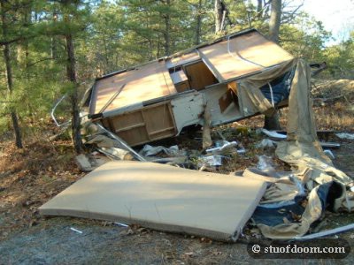
No, this camper has had the top ripped off. Mattresses and whatnot are everywhere.

calico14.jpg


I saw that boat today too. I was wondering if it fell off a hitch, but it did look pretty beat up. It was a pedal boat.
 

bobpbx

Piney
Staff member
Oct 25, 2002
14,723
4,911
Pines; Bamber area
Boyd said:
Did you notice that several months back someone dumped a big pile of concrete blocks and stuff at the bend in the road where Mt. Misery Rd runs into Pasadena? It's still there too.

Someone told me about that in August Boyd, and I happened by there about a day later. Guess what? A truck delivering that "new" block flipped right there. Did you notice how clean the block was? I even found the invoice. What galls me is that no one has cleaned it up. Some say it may be because its an insurance investigation.
 
Top