I love this site... and something that old sparked my interest Great find!
Thanks!!!
I love this site... and something that old sparked my interest Great find!
Kevin,
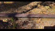
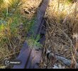
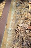
Your photo's also show the one location where the actual ties still show in their original location. And the ditch you photographed is no longer there. It has been repaired and the pipes have been pushed into the woods nearby. That is Salter's Ditch and is man-made. If you look on topo or aerial maps you can see how they used it to add water to what is now Atsion Lake.
Salters Ditch – "'In 1786, a canal was dug from the Mechescautuxen Creek to Atsion River a little above the ore lands belonging to the Batsto Furnace, in order to get a greater head of water over the dam from which Atsion forge obtained its power. Whenever the floodgates were opened the lands below the dam were inundated and the ore diggers were forced to stop
work.' A seven year-long lawsuit ensued. (Early Forges + Furnaces, p. 169)." Joseph Salter
M 83.90.568.
Follow it north and south.
http://maps.njpinebarrens.com/#lat=39.7373728237224&lng=-74.75945234298706&z=16&type=k&gpx=
Now you need to find the Whiting turntable which is half still there.
Guy
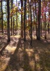
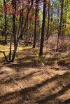
Hello.. I went back to atsion to see the old abandoned railroad, I tried looking for the turntable as everyone mentioned but I did not find it..Guy:
As you note, railroads used turntables to turn locomotives, but seldom used them to turn cars unless you are talking about self-propelled cars, which the R&DB, VRR, and the NJS did not use. Passenger cars featured "walkover" seats--seats where a trainman could reverse the position of the back to allow passengers to ride facing forward.
Although today we think of the rail route through the Pines as one continuous railroad, remember that beginning in October 1870, Atsion served as a junction point between the New Jersey Southern Railroad and Charles K. Landis's Vineland Railway. The turntable and the engine houses (two total) belonged to the Vineland Railway because Atsion represented the company's northernmost terminus. Contrarily, the NJS had the option to turn locomotives at Jackson Junction (now Atco) or to run in reverse back up to Manchester (now Lakehurst), where the NJS maintained its primary shop complex including a roundhouse and turntable. However, I'm sure the NJS engine crews took advantage of the VRR's turntable on occasion.
Good job, Guy, finding the center pivot block and the landscape features representing postbellum railroading in the Pines! I hope you and Jessica enjoyed the exploration opportunity.
Best regards,
Jerseyman
No I didn't get up there until after 1pm..Were you there early this morning around 10:15? I saw a vehicle parked there off of 206.
No I didn't get up there until after 1pm..I stopped at the trussle first, then I went over towards the furnace
It's really interesting about the history there..That's odd. I could believe it if a train full of steel was on the track for years through many fires.
The thing is I think it's strange to have the turntable where it is but why I guess it worked for them.. as for the other track at that wye or turntable, if you go across the street and into the entrance of atsion lake Park, you can see the opening from where the atco track would have been.. I don't know if it's still there?It's really interesting about the history there..
Probably due to wheel slip (from slippery rail, starting a heavy train, etc.)That's odd. I could believe it if a train full of steel was on the track for years through many fires.
The thing is I think it's strange to have the turntable where it is but why I guess it worked for them.. as for the other track at that wye or turntable, if you go across the street and into the entrance of atsion lake Park, you can see the opening from where the atco track would have been.. I don't know if it's still there?
I did find someThe track is not there. If you walk that route you could and maybe still see some of the ties.
I have, but it was for searching out plants. I was not paying attention to the rails or signs, etc. I'm certain Guy has, and some of my botanical friends.If you don't mind me asking, have any of you been to the northern part of the tracks away from atsion lake?