Bobwhite quail

Jim_H

Scout
May 23, 2024
36
21
Medford
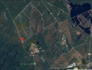
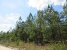
After doing laps on Apple Pie Hill yesterday, I drove down to Speedwell and then returned to the north getting just north of Eagle on the northern edge of the Pine Island forest. I did not get to Eagle and turned around at a hunting lodge. It does appear to be more open around Eagle in imagery. The satellite imagery might not be the most recent and looked to be fairly open in the canopy all over the Pine Island lands, and seemed to be more open in the imagery than what I saw on the ground. The understory was also pretty thick out there unless there was none, and mostly down pine leaves and scattered oak.

Either way, I didn't hear any quail, and the forest didn't really look like it was being managed for them. No idea if they may have been around Eagle. I did see a year or two old pre-commercial timber stand improvement thinning along the northern edge of the lands, so there is still management activity.
 

Teegate

Administrator
Site Administrator
Sep 17, 2002
25,742
8,378
That most likely was the Eagle Point Gun Club. That is Steve Lee's property around the club, not Haines. In any event it is close enough for the quail to migrate to. If you went past a large house under construction that is Eagle. You passed it.

This is all hinged in the event if I have your location correct.
 

Jim_H

Scout
May 23, 2024
36
21
Medford
That most likely was the Eagle Point Gun Club. That is Steve Lee's property around the club, not Haines. In any event it is close enough for the quail to migrate to. If you went past a large house under construction that is Eagle. You passed it.

This is all hinged in the event if I have your location correct.
I have the red marker over the club. No idea about the property boundaries, but some of the land must be Pine Islands. If the county has the records online, it wouldn't take too much time.

My interest was only in finding some quail as I wanted to hear them and hopefully see that they were thriving. Seems like they may have died out, again.

Either way, the road from Apple Pie to Speedwell was where I saw most of the younger forest. Don't know about ownership, but quite a bit of the planted pines are dense enough I would thin them.

at 17:55 Bob Williams talks about a property he had gotten in to a shortleaf savanna prior to acquisition by the state and it becoming a dog hair thicket. It isn't like NJ is a mecca for the lumber industry. It's great to see some managed stands, but if they are doing so for hunting, why land owners aren't seeding in grasses and legumes after intense thinning and burning is a bit of a mystery. The state may love to create low ecological value forests, but private owners could perhaps be motivated to manage.
 

Attachments

  • Screenshot 2024-06-02 at 16-03-48 NJPineBarrens Maps.png
    Screenshot 2024-06-02 at 16-03-48 NJPineBarrens Maps.png
    330.6 KB · Views: 19

Jim_H

Scout
May 23, 2024
36
21
Medford

BTW, anyone interested in shortleaf pine and it's place in NJ, might like to spend some hours watching videos on that channel.
 

Teegate

Administrator
Site Administrator
Sep 17, 2002
25,742
8,378
Your map shows the Eagle Point Gun Club. Many of the members are from the Elmer area. I stopped and talked with them one day and the man I talked with unbelievably was the person who took my uncle to the hospital years ago when he was having a heart attack. My uncle lived in Elmer. A small world. Anyway, the property surrounding the club is Steve Lee's property. All the cut and replanted area is Steve Lee's and the wood was used to make paper hospital gowns. At least that is what Steve Lee told me. And the members of the club told me that were thrilled the woods were cut because the hunting was much better now.

Haines property is further down 563 past Speedwell and I suspect the birds were released further from there even. They most likely did not release them at the bogs. Like I said before, I heard them on Stevenson road many miles from the Speedwell area and that may be where you should be listening. I heard them toward evening but as a kid in rural Marlton at the time, they use to wake me up in the mornings so you may want to also try early morning.
 

Jim_H

Scout
May 23, 2024
36
21
Medford
I was in this area where I heard them.

Okay, so basically I am not in the right area at all.

That point is pretty far out on the road to Warren Grove. I don't know 100% as I am remembering back 24 years, but in 2000 I road my bike to the end of the open portion on that road. I think. Is that road open from 563 to 72? I think there was a fence and gate out near the bombing range, same as near the Allen Road area in 1999, post Allen Road Fire.

I guess I have never actually had confirmation of where the Quail were released, or where the Pine Island Lands are. Once I learned about the release, I sent a message to Bob's office, and never heard back. This was probably close to a year ago.

I thought the area was around Speedwell, possibly due to that town being mentioned in a video or article, and I remembered seeing planted loblolly or loblolly x pitch pine south of the Friendship Speedwell Road in 2005 or 2006, and this led me to believe those lands were where the birds were released and that was the Pine Island Lands.

There is something being done in what looks like wetlands here https://maps.njpinebarrens.com/#lat=39.7455916816197&lng=-74.51173323791502&z=17&type=hybrid&gpx=

How many of the roads out there are open to the public? https://maps.njpinebarrens.com/#lat=39.73094760802738&lng=-74.51162594955443&z=17&type=hybrid&gpx= Would I be able to access the Tranquility Road up to the red dot, from the Lake Oswego RD?
 
Last edited:

Teegate

Administrator
Site Administrator
Sep 17, 2002
25,742
8,378
Bill Haines owns the link below and is cutting all of the cedar. He most certainly would not release birds there. He owns a massive amount of land around there and other than the area he is cutting the other area's are a much more possible location for the release. Again, I don't know where it occurred so I am just guessing.


The gate is at Sim Place which Haines also owns now. But you can't go there and really you can't go anywhere on his property. So you have to stay on the roads to hear them. You can't go to your second link either. Haines owns it and the roads to it.
 

Jim_H

Scout
May 23, 2024
36
21
Medford
Yeah, cedar swamps aren't suitable habitat. Just mentioned it as it looks like something is going on in the imagery.

Was your original dot the location you heard the birds? I can easily drive out to Penn SF when I have the time, and continue out to that area you marked.

Haines must own a lot of land. Probably the largest private owner in the county. As long as he manages the land, and he seems to, then good. He isn't turning the uplands into planted loblolly the way you get in SE Georgia.

Now, if only the state would do something.
 

Teegate

Administrator
Site Administrator
Sep 17, 2002
25,742
8,378
Was your original dot the location you heard the birds? I can easily drive out to Penn SF when I have the time, and continue out to that area you marked.

Haines must own a lot of land. Probably the largest private owner in the county.
Yes, my original dot was the location I was at. There was at the time and large muddy puddle and I had concerns about going through it and was out of my car when I heard one. Haines owns the land basically on both sides there.

I think he may be the largest land owner in the state other than the state. He owns bogs along 72 as well.
 
  • Like
Reactions: Boyd and Jim_H

c1nj

Explorer
Nov 19, 2008
285
183
Whibco is probably the 2nd largest landowner.

"Whibco owns about 12 thousand acres of land and reserves in Cumberland County, New Jersey, including mine permits on 7 different sites in Maurice River Township alone."
 
  • Like
Reactions: Boyd and Jim_H

Boyd

Administrator
Staff member
Site Administrator
Jul 31, 2004
9,598
2,836
Ben's Branch, Stephen Creek
If the county has the records online, it wouldn't take too much time.

You can get basic property ownership and other data from my pinesXT app. Choose any map you like, this one shows parcel boundaries with public openspace shaded green, for example.

https://boydsmaps.com/pines/#15/39.757458/-74.418158/lightstreets/0/0/

Here's aerial imagery with property lines

https://boydsmaps.com/pines/#17/39.771720/-74.571982/parcels07/0/0/

Lots of others to choose from on the menu.
 
  • Like
Reactions: Jim_H

Pinesbucks

Explorer
Apr 15, 2013
298
114
From what I heard Haines and pine island released the birds near the clearcut they did on Stevenson road. So that tracks with what Guy heard. A former member of the site did post on here that alot of the quail were killed off by birds of prey and many did not successfully reproduce.
 
  • Like
Reactions: Jim_H and Teegate
Top