Bog Iron: Can You Dig it, or What is the Marl of the Story?

Folks:

In conducting my research into the dam and lock at Locks Bridge, I came across some interesting material that did not quite fit into the Locks Bridge thread, but I still want to share with you all. Once you construct an iron furnace, you need three basic ingredients to produce pigs or cast products: charcoal, produced from wood in the nearby forest; iron ore; and lime or other fluxing material. For the ironworks at Batsto and, perhaps, Atsion, here is the1765 agreement struck between Estell and Read:

Here is the agreement between John Estell and Charles Read concerning free access to coal wood and ore lands to obtain two out of the three ingredients required for iron production:

West New Jersey Deeds, Liber X:265

This indenture made this twenty-third day of May 1765 Between John Estell of Evesham in the County of Burlington a yeoman of the one part and Charles Read of the City of Burlington Esq. of the other part
Witnesseth that the said John Estell in order to Encourage the erecting of an Iron Works and for and in consideration of the sum of Five shillings to him in hand paid by the said Charles Read the receipt where of is hereby acknowledged
Hath granted bargained and sold and by these presents doth grant bargain and sell unto the said Charles Read his Heirs and Assigns all the coal wood or wood fitt for the making of coal growing or to grow on the lands of the said John Estell in the Counties of Burlington and Gloucester lying near Atsion River, and are the lands purchased of John Monrow and Vincent Leeds and James Inskeep as by their several deeds may appear and also the Ironstone and ore which now is or hereafter may be found on the aforesaid lands and the tops of the saw logs excepting and always reserving such Timber as is fitt for the saw on the same, with ingress and egress into and through the same land with horses oxen carriages and servants and the use of turf or other materials for coaling and Colliers houses and for causewaying and bridging on said lands
TO HAVE AND TO HOLD the above granted priviledges advantages coal wood ore or ironstone to the use of him the said Charles Read his heirs and assigns for ever
In Witness whereof the parties to this indenture have interchangable set their hands and seals the day and year first above written.
John Estell [Seal] sealed and delivered in presence of Rowland Ellis Daniel Ellis, endorsed Be it remembered that on the 23rd day of May 1765 Personally appeared before me John Ladd Esq. one of his majesty's Council for the province of New Jersey John Estell the grantor in the within indenture named and acknowledged that he sealed and delivered the same for the uses and purposes therein mentioned. John Ladd.

The agreement confirms the use of horses and oxen pulling carriages in conducting logging operations. Estell empowered Read with the right of ingress and egress to obtain the timber and ore and also “for causewaying [great word!] and bridging” on Estell’s lands. Finally, it permitted Read to use available turf on both the charcoal pits and also as sheathing on the collier dwellings.

See the next post for the continuation of this message due to the 10,000-character limit of these forums.
 
  • Like
Reactions: Hinchman's Hill
In the Lock Bridge thread, I posted the 1765 legislative Act that permitted Read and Estell to construct dams across the Batstow Creek and the Atsion River, respectively. In his original petition to the legislature, Read wrote:

And whereas the Honourable Charles Read, Esq; by his humble Petition, set forth, that he had proved to Demonstration, good merchantable Bar-Iron may be drawn from such Ore as may be found in plenty in the Bogs and Savannahs in such Parts of this Province which are too poor for Cultivation, which he conceives will be of publick Emolument;

This passage describe where Read intended to obtain his iron ore: “in the Bogs and Savannahs.” To further illuminate this statement, I consulted The Iron Manufacturer’s Guide to the Furnaces, Forges and Rolling Mills of the United States with Discussions of Iron as a Chemical Element, an American Ore, and a Manufactured Article, in Commerce and in History by J.P. Lesley and published in 1859 by John Wiley. The book dates to just 11 years after Batsto ceased iron production, so the process of identifying and mining bog iron ore remained in the collective memory of those involved in the iron industry. The author not only describes the methodology employed to obtain the bog ore, but also where the best quality ore could be found. Lesley writes:

In New Jersey, over the whole southern moiety of which the ferruginous Green-sand and overlying Tertiary formations spread, sulphatic or red-short bog ores abound in all its low grounds, along the foot of hills, in swamps, and wherever waters issue to the air and cannot flow off at once but escape only by evaporation. The Marl, containing phosphate of iron also, gives origin to bogs of phosphatic or cold-short iron ore. “Two great deposits, incomparably the largest in the State, border the principal tributaries of the Little Egg Harbor river. The most western of these is connected with the waters of Atsion river and most of its branches, extending from near the sources of these streams in a tolerably wide belt southeastward to Landing creek—about twenty miles—its average breadth three miles. The eastern tract lies along the Tulpehaukin or Wading river and its several branches, and covers an area quite as extensive as the former, but the deposit of ore is greatly inferior in abundance to that on the Atsion river particularly in the neighborhood of the Atsion iron-works.” The several minor deposits are confined to the limits of the marl region ; one on Talman's branch of the Rancocus; another on the south branch near its junction; another on Manasquan river near Georgia in Monmouth county; others on the Manalapan and Machaponix branches of South river.7
The Atsion river flowing through extensive cedar swamps from an upper country of ferruginous sands (leached and bleached white at the surface) deposits in its ponds three kinds of iron bog, "loam," "seed" and " massive " ore, which is dug chiefly from the shallow coves around the swamps, in tanks of eight or ten feet square with dykes left standing between.
7 Roger's Report of New Jersey, 1840, p. 798.

The massive ore forms the bottom layer, and the loam the top; but sometimes only one kind is met with. The loam ore is the first production, being a mixture of vegetable mould and oxide of iron, at first quite soft, but afterwards, when the iron comes to be in excess and begins to segregate and crystallize in nodules, growing harder, and finally settling to the bottom as a honeycomb mass of crystallized peroxide, its cavities filled up with yellow clay. The "young" pulverulent ore is of course most fusible. The process is so active that stumps and trunks of trees lose all their vegetable matter and are converted into solid iron ore with every line and feature perfectly preserved.

[A table included in the text but not reproducible here analyzed the chemical composition of three ore types: "Seed ore"; "Fresh bog"; and "Honeycomb"]​

The whole Green-sand marl formation is in fact an iron ore deposit thirty feet thick composed one-half of silica, one-quarter of protoxide of iron, one-eighth of potash, and two-sixteenths of alumina and of water, (48.45, 24.31, 12.01, 6.30 and 8.40,) with traces of lime and magnesia.* The same is true of the Greensand of Europe except that in England magnesia replaces potash." It is no wonder then that the drainage and leakage of many centuries should have produced immense bogs of peroxide wherever this Tertiary formation appears above the present level of the Atlantic. But the principal source of the bog deposit is the porous layer of yellow ferruginous sand lying upon the Green-sand marl, kept always distended with water which it dispenses to the Green-sand marl under it, dissolving out its fossil shells and replacing them with casts of peroxide of iron. But unfortunately for the iron-maker the water does not stop here, but continues down not only through Green-sand, but through or along the layers of dark-blue astringent clays which alternate with the Green-sand, and underlie it, and alternate with the Potter's clay beds underneath it. These alum beds contain sulphate of alumina and sulphate of iron, and yield them to the waters, which deposit them among the other constituents of the ore, much to its disadvantage; for its porous, powdery state prevents the usual cure for sulphur, namely, stacking in the open air, because the peroxide of iron itself would also wash away. Bog ore should not be dug long before using. Its iron therefore is necessarily hot-short and chiefly good for casting. (Lesley 1859:739-740)

As time permits, I will continue to seek out contemporaneous source material that will elucidate our knowledge of industries in the Pine Barrens.

Best regards,
Jerseyman
 
  • Like
Reactions: rjb

MarkBNJ

Piney
Jun 17, 2007
1,875
73
Long Valley, NJ
www.markbetz.net
Fascinating stuff, Jerseyman.

>> The process is so active that stumps and trunks of trees lose all their vegetable matter and are converted into solid iron ore with every line and feature perfectly preserved.

Is this true? If so, does anyone know of an existing example?

Something else that caught my eye: he speaks of digging the ore in "tanks of eight or ten feet square" with dikes left between. Were these all carefully filled in? Seems to me that if this was a wide-spread practice some visible artifact should remain of such geometrically regular excavations.

Oh, and in your first post you gave a date as 2765 :).
 
Mark:

Thanx for catching my typo—I have now fixed it! :) No matter how many times you read through a piece, you still miss something!!

I cannot answer your question regarding stumps and trunks; perhaps Spungman will rise from the bottomless deep of a Blue Hole and respond to this issue.

Regarding digging the ore in tanks, I suspect, although I do not know, the miners threw the excavated soil back into the hole. Also keep in mind that the miners extracted most of the ore very close to water or even in the wetlands, so I imagine the rise and fall of the water table caused hydraulic action that aided in refilling the holes, perhaps collapsing the surrounding walls through saturation and sloughing. It could be that our intrepid PBX boys have viewed the results of mining and not even realized what they were seeing. The micro-topography in swamps and along streambanks would display a slight undulating appearance. This is the best I can offer; maybe Spungman or someone else can “wade in” on this discussion.

Best regards,
Jerseyman
 
  • Like
Reactions: pinelandpaddler

Teegate

Administrator
Site Administrator
Sep 17, 2002
25,951
8,695
There was evidence on our hike yesterday there may have been ore digging along the tributary of the Tulpehocken we traveled on.

Nice info Jerseyman!

Guy
 

MarkBNJ

Piney
Jun 17, 2007
1,875
73
Long Valley, NJ
www.markbetz.net
I spent an hour looking at various aerials and satellite imagery, but it's just too easy to engage in wishful seeing. Artifacts in raster images often have regular features, which makes it difficult to assert that the few possibles I spotted were real features of the landscape.

If these tanks were dug as described in a random fashion, here and there, then it would be almost impossible to spot one unless you were standing on it. However the author describes dikes "left between" indicating the pits were dug in groups. If these were very small groups, then again they might be almost impossible to spot on aerials. If there were larger numbers of them in a grid, given how much evidence even a simple, 1500 year-old posthole leaves behind, I have to think they would be readily visible after 250-odd years.

I'm also struggling with why they would bother to excavate this way. Cutting straight down into a bog and leaving vertical walls between 8'-10' pits seems like an overly complicated and dangerous way of proceeding. I think it would make water removal more difficult, if that were necessary, and the walls themselves would not likely be all that stable. You also have to get men in and out of the pit with ladders. Why would they not simply remove layers over a wider area, leaving a larger, possibly irregular pit with sloping sides?
 

Teegate

Administrator
Site Administrator
Sep 17, 2002
25,951
8,695
Mark,

Here is a classic ore bed.

IMG_5626.JPG


IMG_5627.JPG


IMG_5629.JPG

Guy
 
Mark:

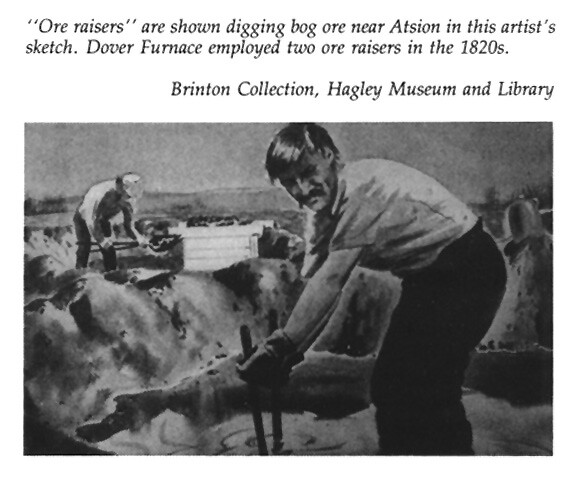
I won’t attempt to defend or explain the text; the source speaks for itself. I will say, however, that you appear to think these excavations went deep enough to require ladders, whereas I think they were rather shallow, depending upon exactly where the ore lay in the overall stratification. I also do not think the walls or dikes were square or straight. Here is a painting that is supposed to show bog ore being mined:

5803929021_68d9d6914b_z.jpg

This appeared in The Trail of the Blue Comet and the original is in the Brinton Collection at Hagley Library in Greenville, Delaware.

Best regards,
Jerseyman
 

Teegate

Administrator
Site Administrator
Sep 17, 2002
25,951
8,695
We found that ore pit at c,xpss4rw303 sorry my keyboard must be going bad :D

Seriously, we found it in the Great Swamp just a few hundred feet from a road.

Guy
 

Spung-Man

Piney
Jan 5, 2009
1,000
729
65
Richland, NJ
www.researchgate.net
Guy, those are nice shots of old ore beds. I will briefly provide an opinion on Jerseyman’s questions.

“I cannot answer your question regarding stumps and trunks”

Bog iron formation is in large part a biological process (Means et al., 1981). Primitive iron-oxidizing bacteria like Thiobacillus ferrooxidans, Leptothrix ochracea, Crenothrix polyspora, Gallionella ferruginea, and Siderococcus geminata are happy to break down organic materials as well, so it is not unusual for them to colonize plant remains. Of course these are not relicts created out of cellulose by alchemy! Nearly all of the resultant iron is exogenous, supplied by water flow from the surrounding ground.

“I suspect, although I do not know, the miners threw the excavated soil back into the hole.”

Ore raisers had no interest in hauling out quartz sand. It was an ore contaminant that would turn into sticky glass if put into the furnace. Sand is also very heavy, much heavier than clay or ore, weighing nearly two tons per cubic yard so why transport something you don’t need? However, the physical properties of quartz surfaces can act as a catalyst for iron precipitation. So, yes, it makes sense to throw it back into the hole to create a well-aerated iron-flocculation nursery for iron-fixing critters. I would think the square seed boxes need not be deep, since at depth the ground was less oxygenated – so with depth less productive and harder to excavate.

“The micro-topography in swamps and along streambanks would display a slight undulating appearance.”

Much of the undulating ground is natural, geomorphic relicts of the our Ice Age wind-and water-related inheritance. Palmer (2005) documented microtopography’s critical importance to the Pinelands plant community. I do not believe that ore raising was as destructive to the region’s wetlands as some suggest, and will soon have some data to test this hypothesis. Many furnaces imported ore from other parts of South Jersey and even from out of State (Braddock-Rogers, 1930).

The Crown expected colonists to buy iron goods from Britain. Phantom bloomeries, forges, and furnaces operated in the Pines to dodge taxes and tariffs. These were primitive affairs, hidden deep in the Pines. In particular shipyards needed wood, naval stores, and iron for their trade, so many had illegal bloomeries. Some industrious settlers went into their backyards and home-brewed iron bits and pieces for personal consumption. It was as simple as taking a hollow black gum stump, lining it with clay, and building a small stone refractory at its base and you were in business (Braddock-Rogers, 1930). Hence early cryptic accounts of furnaces at places like Mays Landing, Weymouth, and old Forgotten Ingersols (Estell Manor) that predate documented legitimate concerns.

Braddock-Rogers, K., 1930: The bog ore industry in South Jersey prior to 1845. Journal
of Chemical Education. 7, 7: 1493-1519.

Means, J.L., Yuretich, R.F., Crerar, D.A., Kinsman, D.J.J, and Borcsik, M.P., 1981:
Hydrogeochemistry of the New Jersey Pine Barrens. Bulletin 76, New Jersey
Geological Survey. 107 pp. (www.state.nj.us/dep/njgs/enviroed/oldpubs/bulletin76.pdf)

Palmer, M., 2005: The Effects of Microtopography on Environmental Conditions, Plant
Performance, and Plant Community Structure in Fens of the New Jersey
Pinelands. Ph.D. dissertation. New Brunswick, NJ: Rutgers, The State University
of New Jersey. 159 pp.

also see Starkey, J., 1962: The bog ore and bog iron industry of South Jersey. The Bulletin New Jersey Academy of Science. 7, 1: 5–8.
 

Spung-Man

Piney
Jan 5, 2009
1,000
729
65
Richland, NJ
www.researchgate.net
Mark,

Great question! I have seen hard, compact masses of iron (concretions) take on many forms including old animal burrows, root casts, and desiccation cracks. A whole stump of ironwood would be quite a find! Most of what I’ve seen have been broken bits and pieces of plant casts. There isn’t a whole lot of digging going on in Pinelands wetlands, so finding an entire stump of “ironwood” would be quite fortuitous today.

However ironstone geodes are commonplace:

IMG_3861.jpg


These have hollow centers, and rattle when shaken. Inside is colored ochre:

IMG_3860.jpg


S-M
 
Top