I have just set myself up for the winter.I went to the Cumberland County Clerk site to check for new deeds on State bought property or Nature Conservancy and Natural Lands Trust deeds and i discovered the site has been update it appears back to 1989.They had only went back to 2002 and I have went over all those deeds.I went through about 300 new deeds and anything with stones mentioned i saved and then started reading them.I have found the Manumuskin Preserve deed! It is 105 pages long and lists probably over 100 stones though many may be duplicates. I immediatley started plotting ones that I could establish a POB on and hopefully will be able to establish more POB"s as I find stones.I started out down at the southerly end of the preserve parked at the end of Barth Road and did about a 4 mile loop.My first stone destination was a semi success.In other words there was no stone but there was a monument at the exact coordinate I plotted with accompanying blank sign.This was on the deed as Anne Carrols Corner and the accompanying sign was probably put there by the Silica Sand Company before the Nature Conservancy bought it.I had noticed this monument in the past but had forgotten about it till I stood at it again.last time I walked by it was in my pre stone hunting days and pre GPS days so it held no interest for me back then. Here are a couple pics of Annes Corner


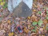
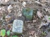
I was expecting to have a lucky day since my declination of 6 degrees was right on the money I figured the rest of this plot would be right on the money.I knew that two stones i could not look for because they were on the very edge of peoples yards.These folks live back in the woods and me snooping around the edge of their yard may have been hazardous to my health but there were two i could look for,one with in sight of a house but far enough a way to avoid detection and i was on Nature Conservancy as well. Both stones were not found.This did not please me but I hiked up my britches and proceeded across a very nice dry vernal pond for a half mile to the Hoffman Back Line.I had searched this line before for stones since it was blazed open four feet across by surveyors in the past and I wandered into it a few years ago.I found nothing then but now i had a plot so i decided to try again.Again nothing other then the DL Stone i found years ago and I took a couple fresh pics today.The stone was planted I believe in 1831 by David Lore who was a store owner/operator in Port Elizabeth and a prolific land owner. This will not be the last we hear from David today.


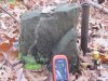
I now headed north to the Fries Mill area and searched for one stone along swamps edge that I did not have enough info to plot to but took an educated guess.I should learn that guesses don't work well in this business.It was a negative on that stone.I then headed up to Fries Mill and looked for two stones near the hole in Manumuskin Creek i learned to swim in at old Camp Hollybrook.Neither stone was there but I didn"t really expect them to be.Area was heavily disturbed in the past and over run by kids for years including me. Stones were of course gone or buried. I then headed for the high light of the day hopefully.This involved a circular route to avoid tresspassing on the property of a man I had run into in the past who gave me the third degree about what i was doing only a few hundred yards from his property each time.This man apparently feels like Manumuskin Preserve is his. but both times (he forgot me the second time) I informed Him that i was not on his property and new exactly where i was and whose property i was on then he suddenly became friendly both times.I found out He is an ex State Trooper so i guess He is trained to treat people like that and to get into others business when it's not his own.In any case my next search was on his line.It would have been very easy to get to if I had walked across his land but i would not have had cocky rights if he caught me on his own dirt so I did the legal thing and circled around through the swamp.It was not as bad as i thought but I did get ripped up getting out of said swamp by a different route trying to short cut back to the road.Short cuts are like guesses,they very seldom work or a price will be paid at any rate.I paid the price.In any case I told you we would hear from David Lore again.Here is what he said.Well at first he faked me out and I wandered into this.


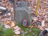
This monument really disappointed me.It told me my plot was on,well almost.It was 50 ft short of my point but it was not the stone mentioned.Something told me to go 50 ft more to my coord and i walked about ten ft and caught sight of something through the brush.Now this was more like it! Talk to me Davy!
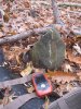
Flip side please!
Shout it at me!

I did a quiet stone dance because at this point shouting would have been heard by Mr. Nibnose if he was home and since I was on his line I couldn't blame him for asking me my business.Now that i was on a stone high I proceeded to head to Schooner Landing road and look for a stone Guy and i searched for off the hartman maps but could not find.Thgis plot fell a little off thatone so i looked but it was too close to the road and it was gone.I then decided to walk further down the road to visit a very nice stone on the Scott Line called Vanamans Corner.I did not have the coord on me since it was a last minute decision but I could remember where it was just out of sight of the road but as i approached the area my heart fell.The stone was actually on the border of NC and Ace Electric land which has been sold to a hunting club. They have logged the area obviously about five years ago by the size of the pine trees growing in the area.I could not find the stone though the old pull off was still visible that I used as a pointer to the stone.On returning home I put my track on the map and I passed within 12 ft of the stone.I am going back to search the exact coord in the small pines,they may have his it.It used to be a gorgeous open oak woods next to a sizable oak.That tree would be a stump now.I am afraid some logger saw the stone and took it or knocked it over with a truck? It was a large and very nice stone.I will have to send Guy the coords and see if he can pull a pic of it up.I no doubt have a pic but am so unorganized i would never find it.That was probably a good seven or eight years ago.
I then went to Schooner Landing road black top section down near Port Elizabeth to hunt one last stone and di not find it.I have a coupel Scott Monuments plotted out there to look for and if i can figure out more POB's then many more stones to plot as well.Plus many deeds of other areas.I should be busy this winter!

 IMG_4318.JPG3.5 MB · Views: 399
 IMG_4320.JPG3.8 MB · Views: 370
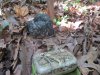 IMG_4321.JPG2.7 MB · Views: 404
 IMG_4325.JPG3.4 MB · Views: 399
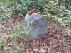 IMG_4327.JPG3.9 MB · Views: 404
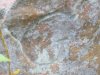 IMG_4328.JPG2.5 MB · Views: 398
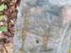 IMG_4329.JPG2.5 MB · Views: 360
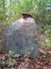 IMG_4330.JPG4.1 MB · Views: 377
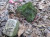 IMG_4332.JPG2.9 MB · Views: 376
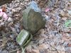 IMG_4333.JPG2.9 MB · Views: 390