Remember, if you give them an inch they will take a mile. That is my take on this.
DEP Announces Virtual Public Meeting to Launch Wharton State Forest Visitor and Vehicle Use Survey
- Thread starter RednekF350
- Start date
You are using an out of date browser. It may not display this or other websites correctly.
You should upgrade or use an alternative browser.
You should upgrade or use an alternative browser.
I had a hard time between these two also. The wording is a little confusing to me. Choice three says areas. I don’t feel any “road” should be closed even if it passes through an area of possible T&E spiecies. 1/4 mile is an area that should be closed but High Crossing Road should not be in my opinion. Another example would be Sandy Causeway. There are several vernal pools on either side of it. I’m sure there’s some T&E species in them. The areas should be off limits to motor vehicles but the road itself should not.Despite some of my friends actually voting in the bottom row, I think that is just a needless anger vote and a touch of temporary insanity if you voted there. I'm in the top one.
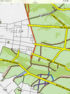
View attachment 21761
But when the radical conservationists with money got involved, we old-timers with a real connection to the land, who know intuitively when to back the vehicle up to avoid damaging our woods, were put in the same basket as those who charge ahead without any thought.
Yup, sadly I agree. Not sure when/how so many people with historical ties to the Pine Barrens were pushed aside, but in the last decade a lot of people with big opinions about the Pine Barrens and loud voices showed up and they sure seemed to come out of nowhere. It's kind of ironic that, despite having a real connection to the Pine Barrens and a real understanding of its ecology, those people (the old timers that you mentioned) feel voiceless. Their contributions would probably be the most valuable.
Last edited:
I'll be one of those old timers with a "real connection" to the Pines perusing The Map tonight.Yup, sadly I agree. Not sure when/how so many people with historical ties to the Pine Barrens were pushed aside, but in the last decade a lot of people with big opinions about the Pine Barrens and loud voices showed up and they sure seemed to come out of nowhere. It's kind of ironic that, despite having a real connection to the Pine Barrens and a real understanding of its ecology, those people (the old timers that you mentioned) feel voiceless. Their contributions would probably be the most valuable.
Is anyone hosting a tailgate before or after ?
") Beforehand would probably be better so we can fuel our anger with alcohol.
Beforehand would probably be better so we can fuel our anger with alcohol. 
I received an email from the DEP at 12:19 today announcing the new MAP is viewable, I try to download and get the old 404 error, nice work they do. I can download any other map on that site except their proposal
They have the road to the Forks open. I think that was closed on the last version of the MAP.They have West Mill road shown open. This looks like the old MAP.
Edit: Is there talk of permanently closing West Mill Rd?
They have West Mill road shown open. This looks like the old MAP.
I was quite surprised by this. It was the first thing I checked.
We really will need a map showing what this proposal would close rather than what it keeps open. I may try to throw that together, if I have some time soon.
Edit: Is there talk of permanently closing West Mill Rd?
West Mill is blocked by Miller's gate from the 206 end, and by the collapsed bridge behind the church at the Pleasant Mills end. So even though it is listed as a driveable road here, currently it's effectively closed to all public vehicular access. I plan to bring this up this evening.
Last edited:
This map is nuts.
So if you were to park on any of the countless high, dry, safe, accessible roads that are are not appearling on the map to hike, hunt or fish, should you expect a ticket when you get back to your car?
So if you were to park on any of the countless high, dry, safe, accessible roads that are are not appearling on the map to hike, hunt or fish, should you expect a ticket when you get back to your car?
This map is nuts.
So if you were to park on any of the countless high, dry, safe, accessible roads that are are not appearling on the map to hike, hunt or fish, should you expect a ticket when you get back to your car?
Yes.
I would imagine that, if implemented, the non-included roads would have those plastic No Motor Vehicles posts put up, blocking them off.
I was not around here for the 2015 MAP and don't know the circumstances of how it was ultimately defeated, but I hope that this is met with a similar response from the public.
NJDEP | Wharton State Forest Visiting Vehicle Use Map| New Jersey State Park Service
NJDEP - Wharton State Forest Visiting Vehicle Use Map
www.nj.gov
Map 8 shows the proposed closures
I have just georeferenced it and exported as a .kmz file along with the 2015 MAP. You can open them both in Google Earth where you can flip between them or make them transparent to compare as an overlay. But they are big files - 36MB each and I don't want any part of them at boydsmaps. I will ask Ben if he'd like to host them here at NJPB. Or maybe @Teegate can upload them here (sorry, I don't have access to that). Can also create tiles for Ben to install in NJPB maps, if he wants to.
Heading out for a walk myself, but will PM Ben and Guy to see if they can take care of this in the meantime.
Heading out for a walk myself, but will PM Ben and Guy to see if they can take care of this in the meantime.
Last edited:
The PDF's might be a little hard to compare because the 2024 version is actually rotated on the page (why??) You fans of "North Up" maps should appreciate that. (this doesn't affect the .kmz files I made, the actual map(s) are correctly georeferenced)

(this doesn't affect the .kmz files I made, the actual map(s) are correctly georeferenced)NJDEP | Wharton State Forest Visiting Vehicle Use Map| New Jersey State Park Service
NJDEP - Wharton State Forest Visiting Vehicle Use Mapwww.nj.gov
Map 8 shows the proposed closures
Ah, this is great, thank you.
They broke down 120miles of “misidentified“ 9ways (colors) but left 200miles of proposed closure brown. What is a historic resource concern anyway, the historic structures they let crumble to the ground? Maybe they don't want them to be seen while you still can. Sadly I’ve been sick since Friday and won’t make it, probably better off anyway…
Last edited:
How long has it been closed from the raceway to Maple Island Rd? I know they closed the wet side behind the houses of the power line but thought the higher and dryer side along the tree line was open. It’s a powerline, what do they think we will hurt that the electric company won’t every time they mow it all down?
Attachments
I was curious about that too. Are they planning on repairing it and was that gate on the west side the Millers gate? Is that gate legal?I was quite surprised by this. It was the first thing I checked.
We really will need a map showing what this proposal would close rather than what it keeps open. I may try to throw that together, if I have some time soon.
West Mill is blocked by Miller's gate from the 206 end, and by the collapsed bridge behind the church at the Pleasant Mills end. So even though it is listed as a driveable road here, currently it's effectively closed to all public vehicular access. I plan to bring this up this evening.