DEP Announces Virtual Public Meeting to Launch Wharton State Forest Visitor and Vehicle Use Survey

Tom Jenkins

New Member
Nov 30, 2016
13
8
79
Pennsauken, NJ
Hey Tom, I admire your photos a lot. You raise an issue I've thought about quite a bit in the past 8 years.

I have walked along, and in, many streams in the Pine Barrens in knee boots, hip boots and chest waders. Most of the best photos I've taken have been in environmentally sensitive areas. For the most part, I explore the same areas that hunters frequent. I know this because I see deer feeders and stands all the time.

If there were 100,000 people walking on sphagnum moss, or into the Tulpehocken, or into the Oswego or Batsto or Mullica or Wading Rivers, down the flooded Road at Deep Run, those areas would be destroyed. But there aren't that many people doing it. Am I acting illegally or unethically?

Hunters trap beaver, kill deer, coyote, turkey, etc. Are they destroying the environment?

If you or I are taking photos of heron or snowy owl and they fly away because they see us, we have disturbed them in their natural environment. Is it illegal? Is it ethical?

If someone drives a 4x4 into a spung, or a river, or goes muddding on legal roads and tears them up and makes the holes deeper, or makes doughnut tire ruts, is it legal or unethical?

If you or I drive down Railroad Ave and use an established go-around, is that illegal?

I know a lot of landscape photographers, and they all walk into savannah, leave roads and trails and walk into the woods, cross cedar swamps. Are we breaking the law? Are we acting unethically? Many use drones, (on this one issue I am clear because drones are 100% illegal in state parks).

It is a complicated issue.
First, thanks for the kind words about the photos, I admire yours also.

It is a complicated issue, but I think much of it is just common sense. Most of us, I hope, can frequent the areas you mentioned, without doing damage, leaving them like we found them.
 
  • Like
Reactions: Jon Holcombe

TommyP

Explorer
Mar 30, 2022
203
191
Clementon
thomaspluck.substack.com
We're seeing a lot of "too much love" in national parks, as well. People talk about overflowing trash, and unburied human spoor all over the place because of limited bathrooms. I use Black Run every weekend and stay on the bike trails, but I think we have to accept some "sacrifice" of natural areas for people to enjoy, as a way to protect endangered habitat. If areas in Black Run that should be protected are being trampled, they can (and do) block off parts as Nature Trails with no bike access, and can fence them off against hikers if needed.
 

Tony

Scout
Jul 30, 2015
73
43
72
Folsom
We're seeing a lot of "too much love" in national parks, as well. People talk about overflowing trash, and unburied human spoor all over the place because of limited bathrooms. I use Black Run every weekend and stay on the bike trails, but I think we have to accept some "sacrifice" of natural areas for people to enjoy, as a way to protect endangered habitat. If areas in Black Run that should be protected are being trampled, they can (and do) block off parts as Nature Trails with no bike access, and can fence them off against hikers if needed.
Leave the forest alone I been riding for over 53 years and nothing has changed< no road closures
 
  • Like
Reactions: Broke Jeep Joe

Teegate

Administrator
Site Administrator
Sep 17, 2002
26,062
8,863
Let me say this again. When I was in eighth grade (1970) my friend would load his Honda 70 into his moms station wagon and she would drive us to the Evans Bogs which now is Kings Grant. We would enter the woods where today is the western entrance to Kings Grant on Taunton Lakes Road. Taunton Lake Road was a quiet peaceful road where we could stand in the road for 10 minutes and a car would not go by. We would enter the sandy pine barren road (Kinds Grant entrance West) and spend the day driving his little motorcycle all through the woods. After a day of riding we would wait at the same intersection for his mom to return to pick us up.

One day while waiting there a vehicle with an earth moving machine on a trailer pulled up and the driver walked over to us and asked if the Evan's Bogs were down the road and how long would it take to get to them. We told him the bogs indeed were down there and 10 minutes should do it. I remember distinctly that the vehicles treads moved independently and it took forever for him to get it off the truck. I then realized it would take more than ten minutes to get there. We had witnessed the first vehicle that had arrived to build Kings Grant. In the coming months we would return on the weekends and they had destroyed the nicest woods you can imagine. It was really frustrating to see even as a young teenager.

My point is, nothing any motorcycle or responsibly used vehicle can do will ever compare to the damage that we witnessed. So when I hear anyone complain about "too much love" and motorcycle damage, I think back to what occurred there and realize how short sighted that mentality is. Everyone in this state who lives in a home where pine woods once stood should sit back and think about what was there before them. Motorcycles are here to stay just like vehicles will continue to drive the roads, and in a hundred years from now they still will not do the damage that I saw at Kings Grant in one summer.

Everyone, please stop complaining about legally used vehicles and motorcycles. They didn't build Kings Grant and others like it that came before and after.
 

Tony

Scout
Jul 30, 2015
73
43
72
Folsom
Let me say this again. When I was in eighth grade (1970) my friend would load his Honda 70 into his moms station wagon and she would drive us to the Evans Bogs which now is Kings Grant. We would enter the woods where today is the western entrance to Kings Grant on Taunton Lakes Road. Taunton Lake Road was a quiet peaceful road where we could stand in the road for 10 minutes and a car would not go by. We would enter the sandy pine barren road (Kinds Grant entrance West) and spend the day driving his little motorcycle all through the woods. After a day of riding we would wait at the same intersection for his mom to return to pick us up.

One day while waiting there a vehicle with an earth moving machine on a trailer pulled up and the driver walked over to us and asked if the Evan's Bogs were down the road and how long would it take to get to them. We told him the bogs indeed were down there and 10 minutes should do it. I remember distinctly that the vehicles treads moved independently and it took forever for him to get it off the truck. I then realized it would take more than ten minutes to get there. We had witnessed the first vehicle that had arrived to build Kings Grant. In the coming months we would return on the weekends and they had destroyed the nicest woods you can imagine. It was really frustrating to see even as a young teenager.

My point is, nothing any motorcycle or responsibly used vehicle can do will ever compare to the damage that we witnessed. So when I hear anyone complain about "too much love" and motorcycle damage, I think back to what occurred there and realize how short sighted that mentality is. Everyone in this state who lives in a home where pine woods once stood should sit back and think about what was there before them. Motorcycles are here to stay just like vehicles will continue to drive the roads, and in a hundred years from now they still will not do the damage that I saw at Kings Grant in one summer.

Everyone, please stop complaining about legally used vehicles and motorcycles. They didn't build Kings Grant and others like it that came before and after.
Well said
 

Jon Holcombe

Explorer
Dec 1, 2015
967
1,934
Medford
Let me say this again. When I was in eighth grade (1970) my friend would load his Honda 70 into his moms station wagon and she would drive us to the Evans Bogs which now is Kings Grant. We would enter the woods where today is the western entrance to Kings Grant on Taunton Lakes Road. Taunton Lake Road was a quiet peaceful road where we could stand in the road for 10 minutes and a car would not go by. We would enter the sandy pine barren road (Kinds Grant entrance West) and spend the day driving his little motorcycle all through the woods. After a day of riding we would wait at the same intersection for his mom to return to pick us up.

One day while waiting there a vehicle with an earth moving machine on a trailer pulled up and the driver walked over to us and asked if the Evan's Bogs were down the road and how long would it take to get to them. We told him the bogs indeed were down there and 10 minutes should do it. I remember distinctly that the vehicles treads moved independently and it took forever for him to get it off the truck. I then realized it would take more than ten minutes to get there. We had witnessed the first vehicle that had arrived to build Kings Grant. In the coming months we would return on the weekends and they had destroyed the nicest woods you can imagine. It was really frustrating to see even as a young teenager.

My point is, nothing any motorcycle or responsibly used vehicle can do will ever compare to the damage that we witnessed. So when I hear anyone complain about "too much love" and motorcycle damage, I think back to what occurred there and realize how short sighted that mentality is. Everyone in this state who lives in a home where pine woods once stood should sit back and think about what was there before them. Motorcycles are here to stay just like vehicles will continue to drive the roads, and in a hundred years from now they still will not do the damage that I saw at Kings Grant in one summer.

Everyone, please stop complaining about legally used vehicles and motorcycles. They didn't build Kings Grant and others like it that came before and after.
Guy, what happened in 1970 in the woods at Kings Grant used to be called "progress".

The development of a supersonic transport in the early 60's was also "progress". Destroying the heart of the Pine Barrens was viewed by many as "progress", until John McPhee's book caught the attention of a liberal New Jersey governor who by some miracle was able to create the Pinelands National Reserve.

As long as the new MAP resembles the 1997 USGS map,and law enforcement is stepped up, I have no problem hiking from Hawkins Bridge Road into the Wading River, or the Tulpehocken.

The Pinelands National Reserve should be viewed, going forward, as a pristine eco-system that is closely watched and protected, and I think that in 2023 that is actual "progress".
 
  • Like
Reactions: TommyP

Teegate

Administrator
Site Administrator
Sep 17, 2002
26,062
8,863
As long as the new MAP resembles the 1997 USGS map,and law enforcement is stepped up, I have no problem hiking from Hawkins Bridge Road into the Wading River, or the Tulpehocken.

I have a problem with that. Just because you and I can do that others may not be able to. Any map telling me where I can go responsibly is not for me.
 

stiltzkin

Explorer
Feb 8, 2022
540
807
Medford
Where can we view the '97 USGS map?

I don't think there is any such thing as a complete map of Wharton done specifically in the year 1997 (see this thread) but there are some true 1997 quads (Atsion, Jenkins, Oswego Lake, Green Bank) which you can view here by setting the slider to 1997-1998. If you expand the date range a bit you can see that the adjacent ones were done in other years (e.g. Indian Mills and Chatsworth in 1995).

It seems odd to refer to a map which doesn't really exist as a baseline.
 

Boyd

Administrator
Staff member
Site Administrator
Jul 31, 2004
9,933
3,085
Ben's Branch, Stephen Creek
Where can we view the '97 USGS map?

Exactly. I would also like to know. :D For what it's worth, here are the dates of all the New Jersey quads used in my USGS 24k Legacy Topo. I used the newest available version from the archives, unless there were quality issues (only a few of those in NJ, IIRC). If you're talking about these old, paper USGS 24k Topo's, there's quite a range of dates, as you can see. However, it is true that 1997 is the newest date for NJ quadrangles - with the exception of Sandy Hook in 1998. By 2000, USGS had pretty much completely shut down the paper maps program. I have only found a handful of quads newer than that out of ~8000 that I have processed so far.

nj_quads.png
 
  • Like
Reactions: bobpbx

Teegate

Administrator
Site Administrator
Sep 17, 2002
26,062
8,863
You can now also click on the Reel at the Open Trails site and view the road closure plan from 2015 and today. This gives you an idea what roads would have been closed in 2015 and for the most part which ones will most likely be closed if the current plan finalizes. Click the link above and most likely you will need to click on the volume icon at the top right.
 
Last edited:

Teegate

Administrator
Site Administrator
Sep 17, 2002
26,062
8,863
No. I will change it so it says 2015. The reel shows the MAP plan in 2015 and what may be the future plan which would most likely be the same.
 
  • Like
Reactions: stiltzkin

enormiss

Explorer
Aug 18, 2015
619
416
Atco NJ
The link isn’t working for me? (I’m not a FB user)

Edit, Found them in google
 
  • Like
Reactions: Teegate

bobpbx

Piney
Staff member
Oct 25, 2002
14,752
4,953
Pines; Bamber area
No matter what happens, the people put up a decent defense. But when the radical conservationists with money got involved, we old-timers with a real connection to the land, who know intuitively when to back the vehicle up to avoid damaging our woods, were put in the same basket as those who charge ahead without any thought.
 

Boyd

Administrator
Staff member
Site Administrator
Jul 31, 2004
9,933
3,085
Ben's Branch, Stephen Creek
The link isn’t working for me? (I’m not a FB user)

I also got an error from that link, but it took me to the FB login page then the link worked after logging in. So, yeah, apparently you need to be a facebook member. I salute you for not being one! I don't go there very often any more.
 

bobpbx

Piney
Staff member
Oct 25, 2002
14,752
4,953
Pines; Bamber area
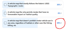
Despite some of my friends actually voting in the bottom row, I think that is just a needless anger vote and a touch of temporary insanity if you voted there. I'm in the top one.

1705335267405.png
 

Attachments

  • 1705335233614.png
    1705335233614.png
    65.1 KB · Views: 57
Top