We spent some time at Friendship Bogs today checking out the burn and revisiting some of the property corners for more detailed photos of the locations. We also visited the reservoir.
View attachment 13540
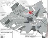
Then to the Bulltown Bogs area to find some of the property corners. These are on the northern portion up towards the rye strips. Stepped over a black racer and Jessica then noticed it and before I could turn around and focus it was gone.
Bulltown Bog corners.
View attachment 13541
View attachment 13542
We noticed sand piled at Friendship today and on our way towards Hawkins Bridge the state dump truck passed us heading towards Friendship. They filled in the donut hole at Fridendship Speedwelll Road and I guess they are working on other locations. Video soon.

")