First snow 2017/2018
- Thread starter dogg57
- Start date
You are using an out of date browser. It may not display this or other websites correctly.
You should upgrade or use an alternative browser.
You should upgrade or use an alternative browser.
I'm going with January 12. But not sure how you want to define "snow", I'd want to see 1 to 2 inches that actually stick, not a dusting or a snow/rain mix. 

But not sure how you want to define "snow",
It's fairly complicated

https://en.wikipedia.org/wiki/Snow#Cloud_physics
Whether it sticks and how much might be two separate polls

Event Summary
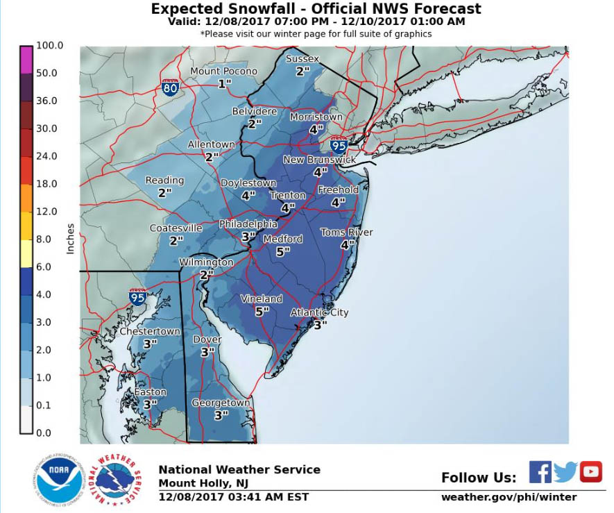
http://www.weather.gov/media/phi/current_briefing.pdf
URGENT - WINTER WEATHER MESSAGE
National Weather Service Mount Holly NJ
544 AM EST Fri Dec 8 2017
NJZ016>027-082300-
/O.CON.KPHI.WS.A.0001.171209T0600Z-171210T0600Z/
Salem-Gloucester-Camden-Northwestern Burlington-Ocean-Cumberland-
Atlantic-Cape May-Atlantic Coastal Cape May-Coastal Atlantic-
Coastal Ocean-Southeastern Burlington-
Including the cities of Pennsville, Glassboro, Camden,
Cherry Hill, Moorestown, Mount Holly, Jackson, Millville,
Hammonton, Cape May Court House, Ocean City, Atlantic City,
Long Beach Island, and Wharton State Forest
544 AM EST Fri Dec 8 2017
...WINTER STORM WATCH REMAINS IN EFFECT FROM LATE TONIGHT THROUGH
LATE SATURDAY NIGHT...
* WHAT...Heavy snow possible. Plan on difficult travel
conditions. Total snow accumulations of 3 to 6 inches are
possible.
* WHERE...Portions of southern New Jersey.
* WHEN...From late tonight through late Saturday night. The
heaviest snow accumulations will occur between 6 AM and 6 PM
Saturday.
* ADDITIONAL DETAILS...Significant reductions in visibility are
possible.
PRECAUTIONARY/PREPAREDNESS ACTIONS...
A Winter Storm Watch means there is potential for significant
snow, sleet or ice accumulations that may impact travel. Continue
to monitor the latest forecasts.
$$
- High confidence for the first snowfall of the area tonight and Saturday.
- Winter Storm Watches and Winter Weather Advisories are in effect,
and the Advisories have been expanded westward. - Mainly a snow event with mixing along the coast.
- Slushy accumulation mainly on untreated surfaces and grassy areas.
- Highest accumulations south of I-195 and east of the I-95 corridor.
- Most of the snow will fall late tonight and Saturday.
- Limited impacts expected...no icing, no coastal flooding
http://www.weather.gov/media/phi/current_briefing.pdf
URGENT - WINTER WEATHER MESSAGE
National Weather Service Mount Holly NJ
544 AM EST Fri Dec 8 2017
NJZ016>027-082300-
/O.CON.KPHI.WS.A.0001.171209T0600Z-171210T0600Z/
Salem-Gloucester-Camden-Northwestern Burlington-Ocean-Cumberland-
Atlantic-Cape May-Atlantic Coastal Cape May-Coastal Atlantic-
Coastal Ocean-Southeastern Burlington-
Including the cities of Pennsville, Glassboro, Camden,
Cherry Hill, Moorestown, Mount Holly, Jackson, Millville,
Hammonton, Cape May Court House, Ocean City, Atlantic City,
Long Beach Island, and Wharton State Forest
544 AM EST Fri Dec 8 2017
...WINTER STORM WATCH REMAINS IN EFFECT FROM LATE TONIGHT THROUGH
LATE SATURDAY NIGHT...
* WHAT...Heavy snow possible. Plan on difficult travel
conditions. Total snow accumulations of 3 to 6 inches are
possible.
* WHERE...Portions of southern New Jersey.
* WHEN...From late tonight through late Saturday night. The
heaviest snow accumulations will occur between 6 AM and 6 PM
Saturday.
* ADDITIONAL DETAILS...Significant reductions in visibility are
possible.
PRECAUTIONARY/PREPAREDNESS ACTIONS...
A Winter Storm Watch means there is potential for significant
snow, sleet or ice accumulations that may impact travel. Continue
to monitor the latest forecasts.
$$
I won't need a snowblower for this. Ground is still very warm, it will be above freezing when most of the snow falls. As the current briefing says "Slushy accumulation mainly on untreated surfaces and grassy areas.".
Why would I waste time with a snowblower for that? I don't start thinking about the snowblower until it piles up over a foot.
Why would I waste time with a snowblower for that? I don't start thinking about the snowblower until it piles up over a foot.

I won't need a snowblower for this. Ground is still very warm, it will be above freezing when most of the snow falls. As the current briefing says "Slushy accumulation mainly on untreated surfaces and grassy areas.".
Why would I waste time with a snowblower for that? I don't start thinking about the snowblower until it piles up over a foot.
Its not a matter of using it, just getting it ready to ward off the snow Gods

Looks like this might put a damper on our trip to see the tree at Rockefeller Center. NYC also expecting about 5".


