Just read their is a major fire in Greenwood, about 100 acres now but expected to grow. Manchester was mentioned, does anyone know a more precise location?
Greenwood fire
- Thread starter tsqurd
- Start date
You are using an out of date browser. It may not display this or other websites correctly.
You should upgrade or use an alternative browser.
You should upgrade or use an alternative browser.
That's not good. Was just wandering around here and thinking that the warm weather and continuing drought have made the woods really dry.
There have been controlled burns this past week and were suspended today.
Current info;
http://www.sectionb10.org/index.html
CURRENT NJ WILDFIRE ACTIVITY
02/19/17
MAJOR WILDFIRE
"Greenwood Wildfire"
02/19/17 @ 1000 hrs- SECTION B5- Greenwood Forest Wildlife Mgmt Area, Manchester Twp- IC's initial report approx. 50-100 acres. Obervation helicopter reports containment lines are holding with no spotting. Size estimated to hold under 400 acres. No structures are currently threatened. Rt 539 is closed due to smoke. Updated 1400 hrs.
Last edited:
I didnt know it was a wildfire. I came into greenwood off 72 and ended up driving right up to it. I thought it was a prescribed burn. I turned around and went back out to 539. It was weird being the only car on 539. Didnt know it was blocked off till I got up to the blockage on 539 north.
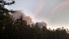
Here's the view of the fire from my back yard in Cream Ridge. No, the farm isn't mine (I wish) but is my neighbors. I do get to enjoy the view of the farm though without having to do any of the work.

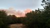
This article has a photo which appears to show the Cedar Bridge tower in the distance. It was reported by the Cedar Bridge tower personnel. Route 539 was closed from Pasadena Road to 72 so it was in that area. It appears you can see this rye field in the photo.
http://maps.njpinebarrens.com/#lat=39.83901762554795&lng=-74.39019698303224&z=15&type=hybrid&gpx=
http://nj1015.com/brush-fire-burns-in-ocean-county-forest/
http://maps.njpinebarrens.com/#lat=39.83901762554795&lng=-74.39019698303224&z=15&type=hybrid&gpx=
http://nj1015.com/brush-fire-burns-in-ocean-county-forest/
I drove up to the fire yesterday or at least a back burn of it. It is north of guys map. It is the piece of woods that has roads on both sides that drive through rye strips. Has a giant hill on the topo map. It is where the helicopter landed in a post a few months ago. I cant post a Map from my phone
It is where the helicopter landed in a post a few months ago.
Funny, that was my post. This is the area in question:
http://maps.njpinebarrens.com/#lat=39.886915550081866&lng=-74.39505508860782&z=17&type=hybrid&gpx=
Yes that's it. I was down the southern end and it looked they may have started a back burn there.