Hampton upper forge?

willy

Scout
Jul 16, 2014
44
14
49
galloway nj
Has anyone located the site of the upper Hampton Forge? Not to be confused with the Washington forge (known as lower forge). The one seen on Gordon's maps on the Batsto river below its confluence with the skit branch and near where the the RR crosses the river?
Thanks
Willy
 

Teegate

Administrator
Site Administrator
Sep 17, 2002
26,003
8,769

Attachments

  • ruins.jpg
    ruins.jpg
    96.9 KB · Views: 381

ecampbell

Piney
Jan 2, 2003
2,894
1,037
I hike and kayak that area frequently and never have seen anything but a boat, circa 1920's. I hiked the high ground from the Skit Bridge at HF to the RR trestle and nothing ever got my attention, however there is not much at LF EXCEPT the man made dam, a real giveaway. Gotta have power.
 
Apr 6, 2004
3,624
565
Galloway
I stand corrected. While I still believe that Upper Forge was located at the confluence of Robbin's Branch and the Batsto River, the only forge in the area depicted on Gordon's map is the one "in ruins".
 

bobpbx

Piney
Staff member
Oct 25, 2002
14,715
4,898
Pines; Bamber area
"The one in ruins" is the one I was wondering if it has been located.

That, Willy, is a very good question. We were up there several years ago on the west side of the river, and the river in this area looks odd, like man had a hand in this one section. It looks sort of dug out and "canalish"?
 

jokerman

Explorer
May 29, 2003
345
17
Manasquan
Its funny because I could swear that some reference books I've read had used the "in ruins" reference to document that the "main" hampton forge was no longer operating at date of referenced map.
 

SuperChooch

Explorer
Aug 26, 2011
394
429
48
I came across this thread in my Hampton research and thought I would add some of what I was writing about because it provides some insight into this question.

The location of the original forge is somewhat in question, but there are several maps and references that help give us clues as to where it may have been.

Ascertaining the location of the furnace is a little easier and more definitive because of the remnants of the slag, however confirming the location of the forge is a little more difficult because it didn’t leave the same footprint. Further, after the iron era the whole area became a cranberry operation, which probably further obfuscated its location and probably changed the landscape.

Let’s start where it was likely not: According to Thomas Gordon’s map of 1828, the forge is downstream of the furnace, somewhere near where today the railroad tracks intersect with the Batsto. The Gordon map also indicates the forge and furnace were “in ruins”, which was also not likely correct at the time.

However, there are other sources that have different information. Historian Charles Boyer stated that the forge and furnace were some distance apart on two different streams. He also stated that the two different ponds on the Batsto and the Skit Branch were known as the “Furnace Pond” and “Forge Pond”, respectively, however there is no other information to back up those names. (Boyer, 1936) This same description of the two ponds is repeated in Family Empire in Iron, but is likely just a citation of Boyer. If we assume that both the Furnace and Forge use a waterwheel to power their respective bellows (and forge hammer in the case of the forge), it would make sense that the furnace and forge would be located at the dam site of a pond. The 1849 map by J.W. Otley and R. Whiteford, provides us the best, most likely, visual on the location. It shows two ponds, one on the Batsto and one on the Skit. It also shows a structure labeled as a saw mill on the Batsto, and an unlabeled structure on the Skit. Since, to this day, there are still slag piles present at the location of the pond on the Batsto, we can deduce then that furnace was on the Batsto and that it is the forge at the other location, on the skit.
Attachment.png

Using these historical maps, we can also see how the town of Hampton changed over the years. By 1849, the Iron Age at Hampton was coming to an end. The furnace was likely no longer in operation and the forge was likely struggling to compete. According to Family Empire in Iron, the forge operations ended around 1850. (Pierce, 1964). This is corroborated by the 1859 "New Map of Burlington County" by William Parry and George Sikes which now only shows a saw mill on the Batso, and no structure on the Skit.
New_map_of_Burlington_County___from_actual_surveys___official_records___Library_of_Congress.jpg

Finally, the 1872 Topographical Map of the Southern Part of Burlington County also shows the two ponds, but now, no structures are indicated.
2b322b19-8b72-4ec8-a9db-c7689997c06f.png
 
Last edited:
I came across this thread in my Hampton research and thought I would add some of what I was writing about because it provides some insight into this question.

The location of the original forge is somewhat in question, but there are several maps and references that help give us clues as to where it may have been.

Ascertaining the location of the furnace is a little easier and more definitive because of the remnants of the slag, however confirming the location of the forge is a little more difficult because it didn’t leave the same footprint. Further, after the iron era the whole area became a cranberry operation, which probably further obfuscated its location and probably changed the landscape.

Let’s start where it was likely not: According to Thomas Gordon’s map of 1828, the forge is downstream of the furnace, somewhere near where today the railroad tracks intersect with the Batsto. The Gordon map also indicates the forge and furnace were “in ruins”, which was also not likely correct at the time.

However, there are other sources that have different information. Historian Charles Boyer stated that the forge and furnace were some distance apart on two different streams. He also stated that the two different ponds on the Batsto and the Skit Branch were known as the “Furnace Pond” and “Forge Pond”, respectively, however there is no other information to back up those names. (Boyer, 1936) This same description of the two ponds is repeated in Family Empire in Iron, but is likely just a citation of Boyer. If we assume that both the Furnace and Forge use a waterwheel to power their respective bellows, it would make sense that the furnace would be located at the dam site of a pond. The 1849 map by J.W. Otley and R. Whiteford, provides us the best, most likely, visual on the location. It shows two ponds, one on the Batsto and one on the Skit. It also shows a structure labeled as a saw mill on the Batsto, and an unlabeled structure on the Skit. Since, to this day, there are still slag piles present at the location of the pond on the Batsto, we can deduce then that furnace was on the Batsto and that it is the forge at the other location, on the skit.
View attachment 18908
Using these historical maps, we can also see how the town of Hampton changed over the years. By 1849, the Iron Age at Hampton was coming to an end. The furnace was likely no longer in operation and the forge was likely struggling to compete. According to Family Empire in Iron, the forge operations ended around 1850. (Pierce, 1964). This is corroborated by the 1859 "New Map of Burlington County" by William Parry and George Sikes which now only shows a saw mill on the Batso, and no structure on the Skit.
View attachment 18910
Finally, the 1872 Topographical Map of the Southern Part of Burlington County also shows the two ponds, but now, no structures are indicated.
View attachment 18909
Nicely prepared, Superchooch. The lack of structures on the 1872 map is not surprising. That atlas only featured roads and rail lines as cultural elements on its plates. Hence, no buildings.

You did miss including the Shamong Township plate from the 1876 Buington County atlas. Here is a detail from that map:
Screenshot_20221222_192522.jpg


As you can see, it does show two buildings where the forge had stood and they are probably associated with the sawmill operation.

Knowing the level of research that Boyer conducted, I suspect he derived the pond identifiers from either deeds or possibly road returns.

Thomas Gordon was such a careful Surveyor and Cartographer. So if he marked something as "in ruins," you can take that to the bank!

Best regards,
Jerseyman
 

Teegate

Administrator
Site Administrator
Sep 17, 2002
26,003
8,769
Thomas Gordon was such a careful Surveyor and Cartographer. So if he marked something as "in ruins," you can take that to the bank!

Best regards,
Jerseyman
Jerseyman,

Do you believe Gordon was correct showing the forge downstream from the furnace? I tend to doubt that. Unless he is referring to Lower Forge and not the Hampton Forge.
 

SuperChooch

Explorer
Aug 26, 2011
394
429
48
Nicely prepared, Superchooch.
Thanks, Jerseyman!

You did miss including the Shamong Township plate from the 1876 Buington County atlas.
Yes! This is another great one to add to my list!

Here is the advertisement from January 1825 for selling the property after William Ashbridge's death:
I have been searching for the digitized version of this ad! It is from the National Gazette and Literary Register in 1825 I believe, right? How did you find it? It didn't seem that any nearby libraries had it.

Since we are discussing the sawmill, there is a question that I have had that I really haven't been able to find info on. (either directly or based on other iron operations) It is reported (including in the ad above) that the furnace and sawmill both operated at the same time. (as did the gristmill) And on some of the maps, the sawmill is shown in the same location as the furnace. So did the sawmill and the furnace share a waterwheel? And possibly did the gristmill as well?

Along these lines, I've been looking for some books that actually describe the technical operations of the forges, furnaces and saw mills. (I.e. how they work) None of the ones I have (Early Forges and Furnaces, Family Empire in Iron, Iron in the Pines) seem to dedicate more than a couple pages to the topic. Anyone have any recommendations?
 
  • Like
Reactions: stiltzkin

SuperChooch

Explorer
Aug 26, 2011
394
429
48
I thought I would come back and add a little more to this since I've done a little more exploration. This is surely a little speculative, but a fun exercise that seems to check out. If you go back to the 1849 map by J.W. Otley and R. Whiteford, you can note a few things:
  • First, there is this nice little "flat spot" on the south end of the forge pond
  • The forge is on the western end of the "flat spot"
  • The raceway continues south of the forge and rejoins the Skit
Map with the flat spot and confluence marked:

1671751138670 copy.png


Of course the area looks nothing like this today, so it is very hard to orient yourself without some additional info. However, if we go back to the 1930 aerials, we can see a time when the forge pond was full, and we can see that the "flat spot" still existed at that time:


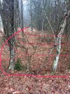
You can definitively verify this location today. Here is a picture from the western edge of the "flat spot" looking north, to where the pond would have been. It is a little hard to see in the picture, so I marked it up in red to help visualize the depression where the pond was. Hard to tell in the pic, but unmistakeable in person:
79CA7726-D2C8-4B1C-B6CE-F9C2EC36C9FF_1_105_c.jpg


So, if turned around 180 degrees and faced south, I should find the remains of a raceway. And sure enough, here it is:


4A9EDD83-5511-466F-9993-74FDD0728AA7_1_105_c.jpg


If I follow this south, it rejoins with the Skit right here:

Here is what that confluence looks like:

Topo_Maps__Trail_Maps__and_Satellite_Imagery.jpg


So, putting the pieces together, it is my assumption that the forge was about here:


This is what that area looks like today:
Screenshot_1_15_23__9_58_AM.jpg


This area would have very much confused me, had Teegate not explained to me what was going on. Again, hard to see in the picture, but in person, there is built up strip running east/west, south of the current road. Teegate explained to me that in the 30's the road was roughly were it was today. However, sometime between the 30's and the 80's it was moved to this location, and then subsequently moved back. Unfortunately, it looks like that old built-up roadbed ran right through where the forge may have been so it might be hard to find any other evidence of its existence.
 

Attachments

  • 79CA7726-D2C8-4B1C-B6CE-F9C2EC36C9FF_1_105_c.jpg
    79CA7726-D2C8-4B1C-B6CE-F9C2EC36C9FF_1_105_c.jpg
    546.4 KB · Views: 89

Teegate

Administrator
Site Administrator
Sep 17, 2002
26,003
8,769
Nice work John! The date of the smaller bridge was during or after 1963 but before 1970 as these aerials show.

This shows the concrete bridge still intact in 1963. You can see the wing walls just above the bridge.

1963.jpg


This shows it washed out in 1970 and the bypass road with the small wooden bridge in place. The concrete bridge and wing walls have collapsed.

1970.jpg


The wooden bridge developed 8/1978

HamptonWoodenBridge8_78.jpg


And the circular bypass road washing out after a storm. Developed 5/1979

Hampton5_79.jpg
 
Last edited:

bobpbx

Piney
Staff member
Oct 25, 2002
14,715
4,898
Pines; Bamber area
Interesting. But I don't see how you can determine a flat spot from that early map.

Edit: oh, you found the flat spot in person and then marked it on the map.
 
Top