Harris Station - a Theory

Ben Ruset

Administrator
Site Administrator
Oct 12, 2004
7,619
1,878
Monmouth County
www.benruset.com
Ok, so there had been some discussion on the site regarding Harris Station and I had always said "I've been there - there is nothing there." Well tonight I got to thinking about Harris Station and I think I discovered something interesting.

First off, I got my names mixed up. I was not at Harris Station, but at Hampton Station. That location only shows up on Delorme TopoUSA and some of the old historic maps. So what of Harris Station?

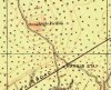
I got to thinking. For it to make sense for Harrisville to ship via rail which was several miles away, you'd want a pretty direct route up to the RR. You have that in the Tuckerton Road. And that brings you right to High Crossing.

So, I believe High Crossing is in fact Harris Station.
 

Oriental

Explorer
Apr 21, 2005
256
140
I think that you may have had it right the first time. It would make more sense that items shipped from Hampton would have been loaded at High Crossing (probably 2 miles away). Harris Station (later known as Pine Crest I think) was just south of Apple Pie Hill. If, in fact, Harrisville carted their product all the way to the rail line (still amazes me) I think they would have followed the main road up to Speedwell. From there there is a road directly to Harris Station. This route is about as straight a line as you could make I think. The road from Speedwell to Harris runs very close to the Tabernacle/Woodland border. Check it out on a map and see if you agree.

On a related topic. Why would someone build a train station (Sandy Ridge - later known as Carranza) Between High Crossing and Harris Station. Wouldn't one of those have been close enough for anyone in the area? My theory is that the Sandy Ridge (Carranza) Station was little more that a siding that cranberries would be shipped from. I would be surprised if there was ever a building there. Wharton's Sandy Ridge Bogs and the Friendship bogs are right in that area. Plus, picture the cranberry harvest from those two locations. They were huge. You would have needed a place to drop off several boxcars for a matter of days or weeks in order to load them. If other people were shipping things out of Harris, there may not have been space to ship cranberries there. The dates appear to match as well. What do you think? What I really need to find are some old shipping records that would indicate what was sent from these different stations. Does anyone know if such records exist?

I just picture Sandy Ridge Station to be a pretty lonely place from December to September.
 

Oriental

Explorer
Apr 21, 2005
256
140
Another thing. Has anyone ever given any thought to why there would even be a Hampton Station? The iron industry was gone by then and the only activity I can think of for miles around were the Rider/Wilkerson bogs there. I don't believe many of these places were train stations like you might think. People from the pines probably were not riding the rails on a regular basis. And people from outside the pines would have no reason to go there. Again, I think that Hampton Station was no more that a siding for loading cranberries. What do you think?
 

suresue592003

Explorer
Apr 4, 2004
372
1
Browns Mills, NJ
When I was alittle girl, my father told me the location of Harris Station. It was the same area you described on the border of Tabernacle and Chatsworth. As for Sandy Ridge...my father used to live there. I was never told of a station there or one referred to as Carranza Station. Yes, there are bogs at Sandy Ridge and several foundation holes of the homes which were there. My old bus driver from Tabernacle also lived there. Her name was Mrs Holloway. She was my dad's neighbor there.
 

Oriental

Explorer
Apr 21, 2005
256
140
Hampton Theory #2

Did you ever see on the maps the road called Rider's Switch in the vicinity of Hampton? It makes a direct line from Hampton Furnace to the railroad and is about half the distance it would be to get to High Crossing. Doesn't it make sense that rider's switch was just that - a switch or siding for railcars. This was certainly the easiest route from the packing house to the rails. What do you think?
 

GermanG

Piney
Apr 2, 2005
1,140
468
Little Egg Harbor
Many stations were merely flagstop stations, with little more than a crude shelter to protect waiting passengers, and not scheduled stops for the trains. I haven't had my copy of The Trail of the Blue Comet out for a while, but it lists all the stations on the CNJ's southern division. I can't remember if it lists what type of station each one was, but it did give the mile marker for each, measured from Jersey City, so the locations should be easy enough to place. I'll try to see if I can find it when I get home from work.
 

Teegate

Administrator
Site Administrator
Sep 17, 2002
25,888
8,593
Ben,
Harris station was as Rich (Oriental) mentioned at what is now Pine Crest. The George cook Atlas #12 shows that. Also, the USGS info on Apple Pie Hill mentions it in the records. Below is the report on the Geodetic Marker on Apple Pie Hill from 1872. Notice it mentions Apple Pie Hill is about 1 mile NNW of Harris Station. That would not be correct at High Crossing.

DESCRIBED BY COAST AND GEODETIC SURVEY 1872 (FWP)
NEAR THE CENTRAL PART OF THE COUNTY, ON APPLE PIE HILL, ABOUT
1-1/4 MILES SOUTH OF THE OLD WHITE HORSE TAVERN, AND ABOUT 1-1/2
MILES NORTH OF RARITAN AND DELAWARE RIVER RAILROAD. IT IS ABOUT
1 MILE NORTH-NORTHWEST OF HARRIS STATION OF THE CENTRAL RAILROAD
OF NEW JERSEY, ABOUT 1-1/2 MILES SOUTH-SOUTHEAST OF SOUTH PARK,
AND 1/8 MILE EAST OF ROAD LEADING TO THE LATTER. IN 1872 IT
WAS BEST APPROACHED FROM SHAMONG, WHICH IS 3-1/2 MILES TO THE
NORTHEAST.


Guy
 

Ben Ruset

Administrator
Site Administrator
Oct 12, 2004
7,619
1,878
Monmouth County
www.benruset.com
Oriental said:
Another thing. Has anyone ever given any thought to why there would even be a Hampton Station? The iron industry was gone by then and the only activity I can think of for miles around were the Rider/Wilkerson bogs there.

The berries needed to be shipped. Having your bogs near a railroad would be ideal.
 

Teegate

Administrator
Site Administrator
Sep 17, 2002
25,888
8,593
Here is the George cook Map.
 

Attachments

  • map.jpg
    map.jpg
    47.6 KB · Views: 520

Oriental

Explorer
Apr 21, 2005
256
140
It makes sense that stops at these stations would be infrequent. I'm suggesting that some stations in the pines probably had no structure there at all and I doubt that there were many (if any) waiting passengers there. Does anyone know for sure if the Blue Comet ever even stopped at a place like Hampton? Atsion and Chatsworth, I can see that, but I wonder about some of the other places.
 

Oriental

Explorer
Apr 21, 2005
256
140
Yes of course you are right about the forge and furnace. But Hampton Station couldn't have had anything to do with the iron industry there anyway (it was way too early right?) Though I keep forgetting just how late the Blue Comet began service, (1929) Hampton must have still been a busy little place with Rider/Wilkerson doing the cranberry thing there. I guess AJ Rider was dead by the Blue Comet era but Clayberger and Goodrich owned and ran the bogs there into the 50's I think. Does anyone know when the packing house burned?
 

Oriental

Explorer
Apr 21, 2005
256
140
Sue,
Someone posted information about the Sandy Ridge (later Carranza) Station that came from the book "Trail of the Blue Comet". It was located somewhere between Carranza Road and Harris Station. There was probably just a siding there. They mentioned the dates that it was in operation and it may have predated your father's experiences there. Maybe someone could post that info again. I guess by the 20's and 30's it would have been much easier to just truck the berries out. Adios Carranza Station!
 

Ben Ruset

Administrator
Site Administrator
Oct 12, 2004
7,619
1,878
Monmouth County
www.benruset.com
I think the bogs were done by Beck's time. IIRC he visited in the 30s. I'd have to re-read the chaper in the Forgotten Towns books to remember.

There is also a lot of information on Sandy Ridge in the revised printing of "Heart of the Pines" by John Pierce.

Edit: The tracks, though, predate the Blue Comet and were likely in place for either the iron days or the bog days.
 

Oriental

Explorer
Apr 21, 2005
256
140
AJ Rider died in 1929 (coincidentially the same year that the Blue Comet began its operation). He was 86 at the time. I don't think he could have been very active at that point. He was the only honorary member of the growers association up til then and was the president of the association in 1920. In the 30's Beck mentions David Kell living there and overseeing the (apparently active) Wilkerson and [Rider] bogs. The description is of a pretty vacant place outside of harvest time. I don't think Hampton Station or Rider's Switch could have been anything more than cranberry pick up points. This seems likely to apply to Parkdale and Sandy Ridge as well. If anyone has some information suggesting much different than this, I would appriciate hearing about it. I really am just trying to get a clear picture myself. Thanks Ben for getting this topic started!
 

GermanG

Piney
Apr 2, 2005
1,140
468
Little Egg Harbor
From The Trail of the Blue Comet:

Mile 87.1
PINE CREST: established 1862 as HARRIS STATION; renamed September 30,1923; station built 1894: freight house built 1884: razed by 1916; discountinued 1938.

(for reference points, Chatsworth was mile 84.3 and Carranza was mile 89.7)

As for the Blue Comet, the book title just refers to the advertising slogan the CNJ used to refer to the route. At the time the station is listed as being established, the line was still owned by the Raritan & Delaware Railroad. The Comet didn't even run until 1929.

also from same book:

91.1
HAMPTON: established 1862; discontinued circa 1875; restored as RYDERS SIDING circa 1895; shelter (freight only ) built as RYDERS 1896; removed in late 1920s.
 

Teegate

Administrator
Site Administrator
Sep 17, 2002
25,888
8,593
GermanG said:
From The Trail of the Blue Comet:

Mile 87.1
PINE CREST: established 1862 as HARRIS STATION; renamed September 30,1923; station built 1894: freight house built 1884: razed by 1916; discountinued 1938.

(for reference points, Chatsworth was mile 84.3 and Carranza was mile 89.7)

A

The 87 mile marker was located in D/M/S at:

39° 47. 49. (N) 074° 34. 47. (W)

In 1938 there was found to just be a shed left there when a nearby Geodetic Marker was searched for. Here is the discription of the marker (S21)

DESCRIBED BY COAST AND GEODETIC SURVEY 1938


2.6 MI SW FROM CHATSWORTH.
2.6 MILES SOUTHWEST ALONG THE CENTRAL RAILROAD OF NEW JERSEY
FROM THE STATION AT CHATSWORTH, BURLINGTON COUNTY, ABOUT 0.2
MILE NORTHEAST OF THE STATION SHED AT PINT CREST, ABOUT 7 RAILS
NORTHEAST OF MILEPOST 87, AT SEMAPHORE R 862, IN THE NORTH END OF
THE WEST FACE OF THE CONCRETE BASE, ABOUT 5 INCHES ABOVE GROUND,
AND ABOUT 1 FOOT LOWER THAN THE TRACK. A STANDARD DISK,
STAMPED S 21 1935 AND SET VERTICALLY.

In a 1995 search for this marker (S21) it was noted that electrical cables were found at the location of where the station was. You may have noticed them in other area's along the lines. They are connected to the rails with large bolts.


I thought I had a photo of the cement base of the mile marker, but I can't find it as of yet. If I do I will have the exact GPS coordinates of it. The above coordinates are very close usually but not exact. If anyone searches, look for the cement base with the 4 bolts sticking up.

Guy
 

Teegate

Administrator
Site Administrator
Sep 17, 2002
25,888
8,593
Jessica and I visited the 87 mile marker this morning and found it. It has been flipped over, most likely when the the steel mile post was stolen by vandals. It weights about 300-400 pounds and I was just able to lift a corner of it slightly to try to turn it over. So we can fairly certain that it has not been moved far. The location in D/M/S is:

39°47.50.1
74°34.47.7

Here is a photo of it upside down.

http://www.njpinebarrens.com/teegate/main.php/download/388-1/IMG_5384.jpg

Since the mile markers go upward as you head west toward Atsion, and the location of the Pine Crest station was at 87.1, it was almost exactly where the road from APH crosses the tracks, or slightly west.

Guy
 
Top