Historic aerial photos

Boyd

Administrator
Staff member
Site Administrator
Jul 31, 2004
9,549
2,809
Ben's Branch, Stephen Creek
I was looking for a site with free topo maps as discussed in another thread, and stumbled on this along the way: http://www.HistoricAerials.com/

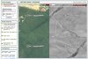
It won't take the place of topozone, but it's kind of cool. In the screenshot below I am comparing Forked River Mountain photos from 2006 and 1956. You drag the slider at the top of the window to show more or less of each year.

To use, go to the link above and enter search criteria in the box on the left where it says "search imagery"
 

Attachments

  • historicarials.jpg
    historicarials.jpg
    175.5 KB · Views: 283

Teegate

Administrator
Site Administrator
Sep 17, 2002
25,653
8,265
Wow! Once I figured it out the site is quite good. Nice one Boyd! You are a legend :)

Guy
 

Teegate

Administrator
Site Administrator
Sep 17, 2002
25,653
8,265
This site is great! I have already found quite a few things I will be checking on in the coming weeks. Also, I noticed that the superfund site off of 72 was there in 1956.

1956super.jpg


Guy
 

Teegate

Administrator
Site Administrator
Sep 17, 2002
25,653
8,265
And the pig farm off of 72 was there in 1956 and 1963, but by 1970 it was destroyed.

1956

pig.jpg


1970

pig1.jpg


Guy
 

LARGO

Piney
Sep 7, 2005
1,552
132
53
Pestletown
BOYD!!!
YOU THE MAN!
Thank you so much. Not only does this site rock, it has filled in some puzzle pieces and confirmed unanswered questions I have had for years on a major topic of interest regarding my area. This site is a treasure. Thanks!

g.
 

Teegate

Administrator
Site Administrator
Sep 17, 2002
25,653
8,265
Go to the Greenwood Forest and zoom out just enough so you can see all the rye fields (letters) and then work you way back through the years. You can see which rye field is the oldest. Then go to the sand company behind Woodmansie and you can see it get smaller and smaller to 1956 when it was in it's infancy. So many things to see.

Guy
 

Teegate

Administrator
Site Administrator
Sep 17, 2002
25,653
8,265
Now it is saying the traffic is high on the site and try later. I know what site is causing all the traffic :)

Guy
 

Jello454

New Member
May 30, 2004
28
1
Piscataway NJ
Site rocks!!!! I found my house use to be next to a farm!!!! I will definitely be on this for a while now!!!!! See what other interesting stuff I can find!!!!!!
 

Teegate

Administrator
Site Administrator
Sep 17, 2002
25,653
8,265
This will be my last one. I was most surprised by this photo. This shows Friendship in 1956 and I bet nobody knew how big the packing house there really was. The cellar hole that is there now was only half the size the building was. And there are buildings all over the place. And take notice the fields. You should go to the site and check other years to see how fast and how much it changed. And SureSue take notice of the road we visited.


friendship.jpg


Guy
 

Teegate

Administrator
Site Administrator
Sep 17, 2002
25,653
8,265
Work on the pumping station above Martha started by 1963. There was a wide path cut that year from the bog to the location it was at. I would say pump house is shown in the photo's so it may have already been in operation.


Guy
 

Teegate

Administrator
Site Administrator
Sep 17, 2002
25,653
8,265
Check out Nash’s Cabin area. The “lake” is there in 1956, but by 1973 it is gone maybe from draining for cranberry use??? You can see the cabin there in 1956, 1963, and 1970 very clearly. In 1995 the lake is much larger which could be from abandonment and beavers taking hold or the state altering it ???

Guy
 

Teegate

Administrator
Site Administrator
Sep 17, 2002
25,653
8,265
I was checking out all the gun clubs in the Martha area looking for the one I can't find from that old photo I have. I noticed you can see the Highland Park Field and Stream Club on the Ives Branch as well as a few others that are no longer there.

Guy
 
Top