How far north?
- Thread starter ironrich
- Start date
You are using an out of date browser. It may not display this or other websites correctly.
You should upgrade or use an alternative browser.
You should upgrade or use an alternative browser.
I am having an argument with my wife as to exactly how far north the Pine Barrens go. Anyone have an idea?
Thanks
There are a couple of boundary definitions; one for the Pinelands National Reserve, another by the state. The link is to a map that shows both of these. For both, the most northern portion in is Jackson Township, Ocean County. Probably a couple more 'unofficial' and 'historic' versions floating around as well.
http://www.state.nj.us/pinelands/pastimes/Interactive%20Pinelands%20Map.pdf
When I was at Rutgers, while we did visit the heart of the Pine Barrens for certain classes and purposes, we went as close as some forests in East Brunswick to see examples of pine barren soils and vegetation. Only the politically drawn boundaries of the barrens have simple lines separating them from other areas. The ecological pine barrens forest type filters away as fingers and pockets as you go north.
Cheesequake
Cheesequake State Park has a few very piney sections, sugar sand and all. I believe it's one of the most northerly "islands" of pine barrens in the state.
http://www.state.nj.us/dep/parksandforests/parks/cheesequake.html
http://en.wikipedia.org/wiki/Cheesequake_State_Park
-Chase
Cheesequake State Park has a few very piney sections, sugar sand and all. I believe it's one of the most northerly "islands" of pine barrens in the state.
http://www.state.nj.us/dep/parksandforests/parks/cheesequake.html
http://en.wikipedia.org/wiki/Cheesequake_State_Park
-Chase
See this: http://forums.njpinebarrens.com/nature-environment/3351-what-constitutes-pine-barrens.html
Also see Howard Boyd's recent book, "The Ecological Pine Barrens". He spends several pages discussing the topic.
Also see Howard Boyd's recent book, "The Ecological Pine Barrens". He spends several pages discussing the topic.
There are many areas down here in millville and vineland that are definitely pine barrens physiographically speaking but are not in the protection area that stays east of union and port cumberland roadsAlso most of manumuskin preserve is not in the pinelands protection area but is as much barrens as anything in wharton.There is also a nice section of oak pine woods in salem county that is dfinitely piney falvot though predominantly oak and way out of the protection area.I say if it sits over the cohansey aquifer it is barrens even if the vegetation has been altered through fire protection or agriculture or urban developement.As long as it's over the aquifer and on sugar sand if left alone it will eventually burn it's way back to barrens.
Al
Al
Ugly things...
Maybe they are in your area. Down here they make up and color our background and define our area of exploration and interest. We don't think of them as ugly.
Ugly things...
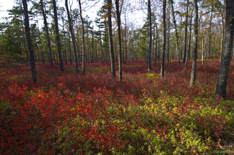
I can't quite see how someone can call this ugly....
I have been working on a project that includes various pineland locations. I came across this shapefile from the DEP that outlines the pine barrens. Once I expand on the map with some labels and stuff, I will post that as well...

Heh, I never thought of pines as ugly. I guess they can be, depending on your perspective. Up here when fall arrives it's the deciduous trees I'm cursing.