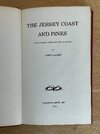
hey everyone. It's been a long while. I recently recieved a book titled Kobbe's jersey coast & pines. It was written in 1889 and a first edition. I haven't had a chance to read it yet, but I have flipped through the pages and found some maps in it. I will post pictures tomorrow. Is anybody on here familiar with this book?

interesting old book i found.
- Thread starter Piney2LA
- Start date
You are using an out of date browser. It may not display this or other websites correctly.
You should upgrade or use an alternative browser.
You should upgrade or use an alternative browser.

I have a copy of that. But mine is a 1977 paperback re-print from the Ocean County Historical Society that was limited to 500 copies, found it in a junk shop many years ago. It's a rather small book that's printed in a tiny little font that's quite difficult to read and also written in an archaic style that I find hard to approach... long sentences with lots of commas. I assumed that people here would be familiar with it. From the preface:
"This aims to be an accurate descriptive guide-book to the Jersey Coast -- from Sandy Hook to Atlantic City -- and to the Jersey Pine Plains. New York City is taken as the stating-point, and the Sandy Hook and Jersey Southern routes as those respectively to the Coast and the Pines; although one chapter, for the sake of completeness, describes the all-rail route via the N. Y. and Long Branch R. R., whose rates of fare are also included in the table of railroad fares in the introduction."
The maps are nice, have thought of scanning, georeferencing and stitching them together into a seamless map someday. The re-print doesn't have any copyright as far as I can tell, except the original one from 1889. As it happens, my scanner is sitting here after scanning some documents for my accountant (tax time!) and I was just about to put it away. Maybe I'll give it a try. The maps are small and aren't likely to reveal all that much, but they're interesting anyway. It's bound very tightly, so I'll need to cut the maps out to get a good scan, that has put me off a bit, but I don't think my copy is all that valuable and it gives me a headache to try to read that tiny type.
Last edited:
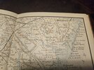
Just gave it a try... my POS scanner is almost 20 years old, I have to use my 10 year old laptop with it. But it chugged along scanning at 1200 DPI and they look pretty good. But there are a bunch of other scans to do and the georeferencing/stitching will take awhile, so I'll just see how it goes. Here's a reduced scale crop from one of the maps, just for fun.

Here's a 100% crop of the 1200 DPI scan

Here's a 100% crop of the 1200 DPI scan
It's bound very tightly, so I'll need to cut the maps out to get a good scan
All scanned, total of
Last edited:
Kobbe's 1889 Map of the Pines is now available, finished it up in one day.  These are very low resolution, inaccurate maps that aren't likely to help you find any property stones, but they're still interesting. I georeferenced them against USGS 250k topo's and there was only so much I could do. The originals just aren't geographically accurate and the 5 individual maps didn't even match each other very well. Basically, I tried to make the coastline match the USGS Topo. Everything in between does not match up very well.
As you go South, the map resolution gets lower, with the Southernmost map only about 1/3 the resolution of the Northern map. This is unfortunate, since a major portion of the Pines is covered by that map. You'll immediately notice the difference as you zoom in, and the geography is also very wrong on that map, you can see the distortion that was introduced by me matching it up to the USGS topo. The Cape is really wrong, and when I tried to stretch to fit, it looked terrible. So I was pretty loose with it, the Southern tip of Cape Map is actually too far North but that was as much distortion as I could tolerate.
But I'm pretty happy, this is a project I've wanted to do for quite a few years but never got around to it. It was just a lucky accident that I had a scanner all set up and ready to go. Thanks to @Piney2LA for reminding me about this (and sorry for the thread hijack).
Access the it in the boydsmaps app here:
https://boydsmaps.com/#13.00/39.755768/-74.448992/kobbe/0.00/0.00
Also available in my new Pines XT app:
https://boydsmaps.com/pines/#12/39.845332/-74.281943/kobbe/0/0/
(Usual disclaimers about the browser cache apply - if you can't access the map, either clear your cache or just wait a few days until it automatically clears)
These are very low resolution, inaccurate maps that aren't likely to help you find any property stones, but they're still interesting. I georeferenced them against USGS 250k topo's and there was only so much I could do. The originals just aren't geographically accurate and the 5 individual maps didn't even match each other very well. Basically, I tried to make the coastline match the USGS Topo. Everything in between does not match up very well.As you go South, the map resolution gets lower, with the Southernmost map only about 1/3 the resolution of the Northern map. This is unfortunate, since a major portion of the Pines is covered by that map. You'll immediately notice the difference as you zoom in, and the geography is also very wrong on that map, you can see the distortion that was introduced by me matching it up to the USGS topo. The Cape is really wrong, and when I tried to stretch to fit, it looked terrible. So I was pretty loose with it, the Southern tip of Cape Map is actually too far North but that was as much distortion as I could tolerate.
But I'm pretty happy, this is a project I've wanted to do for quite a few years but never got around to it. It was just a lucky accident that I had a scanner all set up and ready to go. Thanks to @Piney2LA for reminding me about this (and sorry for the thread hijack).
Access the it in the boydsmaps app here:
https://boydsmaps.com/#13.00/39.755768/-74.448992/kobbe/0.00/0.00
Also available in my new Pines XT app:
https://boydsmaps.com/pines/#12/39.845332/-74.281943/kobbe/0/0/
(Usual disclaimers about the browser cache apply - if you can't access the map, either clear your cache or just wait a few days until it automatically clears)
Last edited:
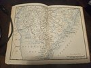
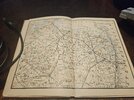


Wow, the originals are in color - very pretty! It looks like the maps are just folded and inserted into the book. Are they? In the re-print, each half of the map is on a separate page with a gap between. How big are the maps? In the reprint that I have, they are about 9 inches wide x 6-5/8 inches high.
size is about the same as yours. unfortunately the maps are not just folded and inserted. it just sp happens that the south jersey map portion is the center page so its just on one single piece of paper.Wow, the originals are in color - very pretty! It looks like the maps are just folded and inserted into the book. Are they? In the re-print, each half of the map is on a separate page with a gap between. How big are the maps? In the reprint that I have, they are about 9 inches wide x 6-5/8 inches high.
That kind of printing must have been expensive in 1889. Did they also publish a black and white version "for the masses"? Or is it just that my 1977 reprint was black and white? Bob - are the maps in your copy printed in color?
Good question. From photos when searching eBay I've found that all originals had maps in color and In the 1970's reprint of 1500 copies, thet are just black and white...That kind of printing must have been expensive in 1889. Did they also publish a black and white version "for the masses"? Or is it just that my 1977 reprint was black and white? Bob - are the maps in your copy printed in color?
The color printing explains an oddity I noticed, portions of the barrier islands aren't shown in the black and white version, just the railroads. But your color version shows the outlines of the islands, so evidently the contrast was too low to be picked up when they screened the map for black and white. Here's an example.
https://boydsmaps.com/#12.00/39.885767/-74.086100/kobbe/0.00/0.00

https://boydsmaps.com/#12.00/39.885767/-74.086100/kobbe/0.00/0.00

Wow - as someone who spent the bulk of his career working in opera, I have seen his other book but never realized it was the same person who wrote this little guide to the Pines.