Iron Mill

Teegate

Administrator
Site Administrator
Sep 17, 2002
25,602
8,177
If you have read the chapter in More Forgotten Towns called "Shinplasters: Chew Town's Money" you will remember Beck visiting Iron Mills. The information in the book is slightly different than his newspaper writings so I will add some info that you may not know. You can follow along in the book if interested.

Beck writes (edited)

One of our traveling followers, Mr. H. K. Bodine, of Pennsauken (I posted photo previously of his grave stone), made out the way to Iron Mills, but said there was only a sluice-way to identify it. We found beside the broken gate and the canal that cuts through a patch of bramble-choked woods, a mound that may have been the site of the mill itself. (Coming up not in the book) If so, the Jersey Central seems to have cut directly through it.

A car can be driven through to the railroad, at the edge of a field where some industrious soul has planted raspberries and other canes, but from here the expeditioner must go ahead on foot.

There are one or two overgrown but distinguishable trails through the woods on the other side of the tracks where the sluice-way meanders on. We tried to find the place where the canal might join the Albertson branch of the river, a wide expanse of cedar water sloshing under the railroad bridge nearby, but we were compelled to turn back after a walk of perhaps two miles in the direction of the Hammonton-Atsion highway (206).

I have been there on quite a few occasions but had not read about his thoughts that the Jersey Central may have ran right through the mill. So Jessica and I pulled up there early this morning to check it out. Getting out of our vehicle by the bridge at Fleming Pike and Wharton State Forest Road, I started hearing voices and looked up to see three young men in gym shorts jogging towards us exiting Wharton State Forest Road. Then one minute later a man and his daughter jogging by from the same location.

Anyway, if you go to the Iron Mill bridge and stand on the SE side of it you can actually see the canal at it's beginning. The below link should be right on it.
You can see where the stream turns at the bridge and heads away from the canal.


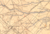
So we go to the Jersey Central walking past the massive amount of vegetation someone dumped there, and passing the cut rails, we walked down the tracks to here where you can see on the map the canal crossed at that point in the past.


Looking around along the tracks on the eastern side it does appear that the mill may have been there but I am uncertain. On the western side you can make out some sort of canal or open area. However, Beck said he walked maybe two miles along the canal to find where it meets the Albertson branch, but it looks to me he missed the spot right at the beginning. I say it is here. I will have to go back in the winter to look more.


I suspect this is the mound Beck mentions.

IMG_4972a.jpg


Also, it does appear that this area may have been the lake formed by the mill but again I am uncertain. If you go look at this area from the tracks.


Also, the field Beck mentioned that had raspberries had to have been this one and/or the much larger one that is still there today. BTW, I was also there yesterday and the owner appeared to have just finished cutting that big field.


On a different subject, if you go there look where someone has cut down a huge tree in the past. I am wondering if the cut the rails there to get a vehicle to the tree? I can tell you the rails were cut in 2004 when I was there with Ben, so I may be wrong.


Ben and I were there in January of 2004 so I took that photo and added one from today to make a "Then And Now." FYI, Jessica made me alter today's photo, so extra points if you can figure that out if you go there. Take the photo with you and post back the difference, if you really want to :)

Iron Mill Bridge Then & Now.jpg


And the bridge in the photo is either not the same one or they repaired it. I can tell that from the photo I took looking under the bridge in 2004. This is not showing there today. Could the stones have been from the workings at the mill????

IMG_3028a.jpg
 

LARGO

Piney
Sep 7, 2005
1,552
132
53
Pestletown
Yall may remember back in the day me writing about this and the Alberston creek, the Trestle, and the Mill itself.
I am originally from the Fleming pike right down the street where in fact I spent younger years playing all sorts of make believe adventures of the grade school fashion on one of those very stones that still had studs in it on the old homestead.
I have a pic somewhere. I will post if I find.
When all the family was gone and the one Auntie left sold it to a local farmer I did ask him if I could have the stone
(certainly a job for the backhoe)
He declined, listening to my tales of history and took an interest in it.
He died and his young had it removed. BASTARDS..!! I really wanted my own stone right here on Pestletown Road in Waterford.
Since my Homestead on the Fleming Pike was losing it anyway.

As a child when that creek-river was deeper and flowed better, Before a farmer up the line dammed it to make a nice (lake) for his property, (That name I won't put in print) it flowed cool and deep. We washed the dogs there some afternoons. Filled the water truck.
And.......... yours truly learned to swim. (More like cry and struggle) being tossed off the original bridge.

It is now nothing more than a weed choked trickle and it's all you can do to get at the trestle.

At one time that mega sized Oak just to the right was the edge of the circle that was the edge of a long forgotten spillway.

I used to still make trips out there on a regular basis to share wonders with my Cillun' but all the B.S. going on just had me stop going back there.

Up the way a bit just on the right of the tracks is a fenced in field where old Carmen Grasso used to grow this and that over the years but it has been there as long as I can recall.

And I must say over the years admittedly, I've enjoyed some festivities out here.

I am reasonably sure memory being selective A couple of us fellows took a ride back that way once...
And among us was Scott with his 490 or 500 CC dirt bike I couldn't even manage on my tippy toes.
One other guy tried it and I do not recall him doing well..

Ahhh memories.

g
 
Last edited:

Teegate

Administrator
Site Administrator
Sep 17, 2002
25,602
8,177
Is the oak you are referring to the one I mentioned and has been cut? That would be on the other side of the tracks just past the trestle.

I guess the fast flow of the river back then is why Beck said "a wide expanse of cedar water sloshing under the railroad bridge nearby." Not much sloshing anymore.
 

LARGO

Piney
Sep 7, 2005
1,552
132
53
Pestletown
Went out there about 20 minutes ago.
Nahhh,
The one I am thinking of is still there. Big White Oak, if I are calling her correctly.
 

Teegate

Administrator
Site Administrator
Sep 17, 2002
25,602
8,177
Okay. I will stop in one day and photograph the stump.

BTW, that sawmill you told me about years ago. If you don't have direct information on who used it I may have some. It MAY have been used by Frank Ware.
 

LARGO

Piney
Sep 7, 2005
1,552
132
53
Pestletown
So Guy, you crafty bugger, got me pining (No pun intended) for the Fleming Pike, the old homestead, and the bridge.
I found with some caution, the Fleming Pike of my youth is still pretty traversable.
The Bridge, looking from The North and South...
1.jpg
2.jpg
2.jpg
1.jpg


1.jpg
2.jpg

Somehow I double clicked those attachments. My bad. I'm sure you can fix it Guy. I are too stooopid.

And... If you know exactly what you are looking for... THE SPILLWAY....


3.jpg


It was a nice look at the past. On the way out Some of the same Burms that backdoor you over the tracks to the turf farms are still there but...... Some things ya just don't do.

Needless to say I got some very unusual looks from the migrant workers as I exited the wooded road.

Stopped by what is left of Ten Oaks Farms (My Grandpappy's place)
All that remains is the largest Oak that centered the back yard where we used to hang pigs to skin them after the winter kill. I know exactly where the stone was by proximity so I poked around, to see if it was just pushed out of the way with no luck.

I now have a new mission. Find the owners, hope they didn't ship it off in a Hargrove dumpster, hope they just put it up the top of the woods back of the property, and if so, make arrangements to procure it.
Bring a piece of my childhood and Pine Barrens history to rest on Pestletown road. Win Win.
Wish me well.

g
 

Teegate

Administrator
Site Administrator
Sep 17, 2002
25,602
8,177
Will read it more closely tomorrow. Heading to bed. The spillway is the canal I mentioned in my post.
 

LARGO

Piney
Sep 7, 2005
1,552
132
53
Pestletown
If it is any help at all that particular trestle over the Albertson is jest a touch east of the Mill.
The Mill was pert much at the bridge give or take. I have that bit of info in a book Jerseyman gifted to me.
That also makes a loose reference to the Mill that may have worked off the stone base on my Grandparent's place.
But, when I was a child you didn't need a book to see the lay of the whole thing.
It was as obvious as can be.
And the water flowed strong and deep before said party up the line dammed it off.
I remember clearly my dad swimming up to his neck or better and the current was a strong as any good moving piece of the Mullica. Traversable all the way to 206 by canoe or walking the banks.
Standing on the trestle could be unnerving given the whoosh of the water below.

And your rails on the bridge, I don't think it had to do with a tree... well, the old rails had gotten into some terribly sad shape, dangerous even.
We may not even be talking about the same tree.
One day I went back by quad and well, someone, the forestry service maybe, don't know, had wacked down the posts and slapped a new set of rails on.
Not a very well engineered type of deal, sort of a cheater's way out, but it's like at one point the old was there and then... they weren't

All this of course is just information from a kid from Elm who watched these changes take place as he grew, and even later in life as an adult.
 

Boyd

Administrator
Staff member
Site Administrator
Jul 31, 2004
9,502
2,765
Ben's Branch, Stephen Creek
I really hate to be the spoil-sport here, but Ben is very clear with his policy about not posting copyrighted material without permission. That book was published in 2002, so I assume it is still copyrighted unless you have information to the contrary.

It's OK to summarize or quote from a book, but scans of pages can't be used. If you'd like to edit your posts, that's fine. Otherwise I will have to delete the scans, unless you have permission or can show that this isn't copyrighted material. Sorry... :(
 

LARGO

Piney
Sep 7, 2005
1,552
132
53
Pestletown
Crap...
You are absolutely right Boyd and I forgot. Good catch.
Guess it shows I've been away more than a minute.
I believe I successfully deleted them. Check me though.

g
 
  • Like
Reactions: Boyd

Teegate

Administrator
Site Administrator
Sep 17, 2002
25,602
8,177
If it is any help at all that particular trestle over the Albertson is jest a touch east of the Mill.
The Mill was pert much at the bridge give or take. I have that bit of info in a book Jerseyman gifted to me.
That also makes a loose reference to the Mill that may have worked off the stone base on my Grandparent's place.
But, when I was a child you didn't need a book to see the lay of the whole thing.
It was as obvious as can be.
And the water flowed strong and deep before said party up the line dammed it off.
I remember clearly my dad swimming up to his neck or better and the current was a strong as any good moving piece of the Mullica. Traversable all the way to 206 by canoe or walking the banks.
Standing on the trestle could be unnerving given the whoosh of the water below.

And your rails on the bridge, I don't think it had to do with a tree... well, the old rails had gotten into some terribly sad shape, dangerous even.
We may not even be talking about the same tree.
One day I went back by quad and well, someone, the forestry service maybe, don't know, had wacked down the posts and slapped a new set of rails on.
Not a very well engineered type of deal, sort of a cheater's way out, but it's like at one point the old was there and then... they weren't

All this of course is just information from a kid from Elm who watched these changes take place as he grew, and even later in life as an adult.


I am quite sure the stones in my photo were part of the mill since I am also quite certain now that the bridge was where the mill was as you mention. That is why the spillway or canal starts there.

There is a chance the stones are still there but they have covered them over with a new addition to the bridge.
 
  • Like
Reactions: LARGO

LARGO

Piney
Sep 7, 2005
1,552
132
53
Pestletown
I am quite sure the stones in my photo were part of the mill since I am also quite certain now that the bridge was where the mill was as you mention. That is why the spillway or canal starts there.

There is a chance the stones are still there but they have covered them over with a new addition to the bridge.

And I will give you that's a pretty good point guy.
Wish I had some input from my childhood on that but while I do actually remember the stones around the bridge, I wasn't exactly pondering why the stones were there back then. As a kid you're thinking about trolls under bridges hiding behind pilings and stones. Ahhh youth.
 

LARGO

Piney
Sep 7, 2005
1,552
132
53
Pestletown
O.K.,
Just for grins and to further stimulate the curious, I clipped a bit off the historic topo, and since I'm working from that, with some really confident guess work and some basic memory of where the homestead would have fallen... I dropped a little dot, I'll guess pretty darn close to where the mill base I played on as a child was. Big ol' rectangular block with a couple or three studs still sticking out of it. And if you walked alllll the way to the back of my grandfathers property, A little homemade wooden foot bridge spanned that teensy bit of the Blue Anchor Branch to an adjoining property.
I think the Bailey family actually owned that. I'm grasping a little there.
It was a pretty shaky and pathetic bridge. Wild Huckleberry bushes heavily laden with sweet, and some, if you didn't watch out... nasty sour berries populated that whole area very clear trail ran along the branch that eventually came to the Albertson bridge.
About the time I was 7 ish, my pop took the beat up deck off an old riding mower so I could tool around the property. I remember it was all white, maybe Sears, maybe not, but the engine was a Tecumseh. I remember the Indian plate clear as day. Had one of those half steering wheels on it.
I would drive that silly thing all the way down to the bridge and the trail along the bank till I was afraid of getting stuck.
I remember bringing cans, coffee cans maybe, and topping them off with Huckleberries to bring back.
Man, I was Country come to Town.
Holy Cow the things that come back once you get your thinker thinking.
1595626703713.png


Looking at the proximity, in retrospect does it show that in all my life's travels I haven't exactly landed but a few miles through the woods from were I were born?
 

Attachments

  • 1595626702737.png
    1595626702737.png
    758.3 KB · Views: 160
Last edited:
  • Like
Reactions: bobpbx and Boyd

LARGO

Piney
Sep 7, 2005
1,552
132
53
Pestletown
Oh,
Guys... just a tribute to how long Ben has been providing such an amazing site...
It was around a good bit I guess before I joined and....
My youngest, Jason, who coined my very signature quote when I would take him to the woods at the homestead... My Grandpop was still alive then... that same Jason got his license two weeks ago and is now driving himself to work @ 17 years of age.

The first time I ever took him there and walked "up the woods" as we say, to what was left of that trail....
I asked him what he saw, he could barely toddle along, and linguistically hadn't a large volume of words to put into use but he said.

"There are birds, and sticks, and trees"

My Lord, I just had to hold back a couple tears.


g
 

RednekF350

Piney
Feb 20, 2004
4,944
3,080
Pestletown, N.J.
........Looking at the proximity, in retrospect does it show that in all my life's travels I haven't exactly landed but a few miles through the woods from were I were born?

Only a 30 minute walk through the woods George. You have truly earned Country Bumpkin status. Much better than City Slicker status in my book ! ;)
 
  • Like
Reactions: manumuskin
Top