Lower Forge-High Crossing Road

Maggie

Scout
Sep 16, 2015
43
23
Three Bridges, NJ
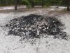
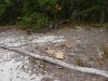
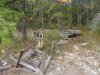
I've already let it be known that I am clueless regarding technology. If I screw this up royally, I do apologize. I'm guessing you all probably know about this disgusting site (LF-HC). 3 foot tall bonfire cinder cone; beer bottles and cans strewn everywhere; underwear, socks, other random textiles; condoms; a stockpile of wood pallets for future debauchery. Wooden chairs from somebody's old family kitchen; wrecked sand thanks to joyriding a-holes;

Why can't the park police do something (for example, show up every Friday and Saturday night at this known site once in a while until they inevitably bust someone here)? And then clean it up. I'll help.

Why do I worry when I stealth camp, solo, with no fire, no tent and zero impact (at other places, not here of course) because I want to be alone and listen to the frogs, birds, and insects? Because I'm a fool, a sucker, what?
 

Attachments

  • P1010367_gross party site.JPG
    P1010367_gross party site.JPG
    1.4 MB · Views: 340
  • P1010368_gross party site2.JPG
    P1010368_gross party site2.JPG
    1.4 MB · Views: 409
  • P1010369_gross party site3.JPG
    P1010369_gross party site3.JPG
    1.4 MB · Views: 440
Last edited:

bobpbx

Piney
Staff member
Oct 25, 2002
14,549
4,715
Pines; Bamber area
Is it really that far out in the woods Maggie (lower forge high crossing road)? That is surprising. I didn't think local teens would go out that far, risking a ranger visit, however scarce that may be. Usually they are closer to the towns they live in. Yes, they do that on Forked River Mountain, but still, that is only about 4 miles from Forked River.
 

ecampbell

Piney
Jan 2, 2003
2,865
1,005
No, the road is not closed and it is marked as open on the MAP map.

That has been a party spot since the fall of 2012.
 

SuperChooch

Explorer
Aug 26, 2011
394
429
48
Correct me if I'm wrong, but isn't that road already closed to motor vehicles.
Lower Forge - High Crossing is open, but it has had a tree across it for at least a couple months. I was just out there this past weekend on my way to Mannis Duck pond area and must have missed this party spot.

Maggie, re your question I was going to be emailing the superintendent about another topic, I'll ask him how he would like us to report these types of issues. Not sure that he'll have a good answer, but I'll ask....
 

ecampbell

Piney
Jan 2, 2003
2,865
1,005
Please don't report it, they will just close the road. That's what happened the last time I brought attention to a problem, and now I can't use the road. Never again!
 
  • Like
Reactions: noboat

SuperChooch

Explorer
Aug 26, 2011
394
429
48
I
Please don't report it, they will just close the road. That's what happened the last time I brought attention to a problem, and now I can't use the road. Never again!

Huh. Closed recently as part of this MAP debacle or before that?
 

ecampbell

Piney
Jan 2, 2003
2,865
1,005
It was never closed, and is not on the MAP. The road off of it that leads to Quarter Mile is closed. We don't need to hand them reasons to close another road.
 
  • Like
Reactions: smoke_jumper

smoke_jumper

Piney
Mar 5, 2012
1,565
1,088
Atco, NJ
I believe so. I know Mines Spung Road is open and I thought everything around Mannis Duck pond and Lower Forge was closed. A few weeks ago I was on Mines Spung and followed it out to Pushline Road. There was a tree down across the turn off to lower forge. I just thought it was closed and continued down Mines Spung.
 

Maggie

Scout
Sep 16, 2015
43
23
Three Bridges, NJ
Were talking about Lower Forge - High Crossing Road. other wise known as Mines Spung Road.

http://maps.njpinebarrens.com/#lat=39.76249243581146&lng=-74.6445133129883&z=15&type=terrain&gpx=

Yes--this is exactly the spot I'm talking about. I see on some maps it's called Lower Forge-High Crossing Rd (for instance, on the "MAP", which shows it open) and on others it's Mines Spung Rd. It's really a mess. Are you serious that we shouldn't report things like this? It would seem really, really easy to bust a party there--fine them good and make them clean it up.
 

ecampbell

Piney
Jan 2, 2003
2,865
1,005
It was easy to bust the parties at Quarter Mile, but it never happened. It will just give them ammunition to close off another road., especially now with negotiations over MAP. I cleaned up a lot of broken glass there. My dogs love to run in the sand. Maybe talk to the Park Police but not the DEP. No good will come from talking to Rob, they have dug in and want us out.
 

Maggie

Scout
Sep 16, 2015
43
23
Three Bridges, NJ
It was easy to bust the parties at Quarter Mile, but it never happened. It will just give them ammunition to close off another road., especially now with negotiations over MAP. I cleaned up a lot of broken glass there. My dogs love to run in the sand. Maybe talk to the Park Police but not the DEP. No good will come from talking to Rob, they have dug in and want us out.

Wow, that is really depressing. :(
 

smoke_jumper

Piney
Mar 5, 2012
1,565
1,088
Atco, NJ
I would suggest one never tells him anything or ask anything of him again.
Unfortunately. I agree also. The park police also fall under the DEP so reporting it directly to them is still reporting it. There are many "party spots" out there. Reporting the active ones gives the park police areas to target, when they can. Personally I always have a box of trash bags on me. My 5 year old calls it "Cleaning up the Earf".
 

Maggie

Scout
Sep 16, 2015
43
23
Three Bridges, NJ
I'll take it from you guys as the experts. No reporting.
I carry out small amounts of trash too, but all those pallets and chairs and things...well that's just beyond my abilities!
 

Maggie

Scout
Sep 16, 2015
43
23
Three Bridges, NJ
On a lighter note Maggie, what do you like about the area?

Ah, yes. I hear you--don’t mean to seem so negative. I love the pines. So besides being irked about the behavior of slobs, I like everything about the area.

A couple of weeks ago (before it rained), I walked from Batsto village to Mannis Duck Pond and beyond, starting by following the river past the Lower Forge campground and up to where the stream that flows from the pond crosses the road (don’t know the name of that road). There are a couple of trails (seem like abandoned roads) not marked on any maps I’ve seen that become very overgrown at some point and then open up again. The upper part of the pond was completely dry and it was very cool to view and walk around the black, mucky bottom of the pond (making minimal impressions—not postholing), with all the animal tracks (raccoon, deer and geese mostly, but also some I couldn't identify, not that I’m skilled). Talk about peaceful. I didn't see a human being for two-plus days, except for a couple of jeeps on Tuckerton Road (normal people). I came across three rough green snakes. The smell of the pines, the solitude, and the quietness of the area give me a very palpable sense of well-being. It’s a real stress-buster. I'm making my Thanksgiving cranberry sauce with the berries I picked.

I found somebody’s keys on that road/trail between the pond and Mines Spung Road. Turned them in at the Batsto visitor center.

Edit: don't know what happened to that first picture. There should be a green snake in it. Huh. And now it's back.

P1010291_GreenSnake_9.25.15.JPG
P1010297.JPG
P1010339_cranberries.JPG
P1010346_jointweed.JPG
P1010352_LF 1962 Deer Club.JPG
P1010361_fall colors_huckleberry.JPG
P1010393_drying pond_upper MDP.JPG
P1010403_drying pond_raccoon tracks.JPG
P1010408_muck.JPG
P1010439_fall color2.JPG
P1010291_GreenSnake_9.25.15.JPG P1010297.JPG P1010339_cranberries.JPG P1010346_jointweed.JPG P1010352_LF 1962 Deer Club.JPG P1010361_fall colors_huckleberry.JPG P1010393_drying pond_upper MDP.JPG P1010403_drying pond_raccoon tracks.JPG P1010408_muck.JPG P1010439_fall color2.JPG
 
Last edited:
Top