North of Lower Forge

SuperChooch

Explorer
Aug 26, 2011
391
428
47
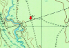
After the thread on Mannis Duck Pond, I remembered I wanted to hike the area north of Lower Forge, specifically, this little dog leg off of the main trail:
Screen Shot 2016-06-18 at 6.01.09 PM.png


The trail was nearly completely reclaimed in places, but fairly open in others. Sometimes it was hard to even find:
IMG_1140.jpg


I came across this tree that had the bark stripped off in a line from the top to the bottom. My guess is a lightning strike?

You can see how high the stripe goes:
IMG_1144.jpg

And it went right down to ground level:
IMG_1145.jpg

Up close. I thought if it was lightning, it would be burned, but I didn't see any char:
IMG_1146.jpg


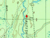
Also stopped at location of this structure marked on the map:
Screen Shot 2016-06-19 at 8.34.32 AM.png

Nothing there but a depression:
IMG_1147.jpg


Continued in reply, can't post any more images....
 

Attachments

  • Screen Shot 2016-06-19 at 8.37.44 AM.png
    Screen Shot 2016-06-19 at 8.37.44 AM.png
    600.5 KB · Views: 242
  • Screen Shot 2016-06-19 at 8.38.16 AM.png
    Screen Shot 2016-06-19 at 8.38.16 AM.png
    648.7 KB · Views: 281
  • Screen Shot 2016-06-19 at 8.45.21 AM.png
    Screen Shot 2016-06-19 at 8.45.21 AM.png
    1.2 MB · Views: 268

SuperChooch

Explorer
Aug 26, 2011
391
428
47
Then I headed up to the location that Don Catts has previously identifed as the Lower Forge hunting club:
Screen Shot 2016-06-19 at 8.38.16 AM.png


Nothing there remaining however, I did just find a new lunch spot for kayaking on the Batsto. :)

I noted this square on the township border. I wasn't sure if that meant if there was suppossed to be some sort of marker there. I'm sure Guy will know :) I looked around briefly but didn't see anything.
Screen Shot 2016-06-19 at 8.37.44 AM.png


This little guy was doing his best to hide from me:
IMG_1155.jpg

This was my track. A little over 4 miles.
Screen Shot 2016-06-19 at 8.45.21 AM.png
 

smoke_jumper

Piney
Mar 5, 2012
1,518
1,048
Atco, NJ
That is a nice area. One that I haven't been to in a while. I've always wanted to explore the eastern side of the Batsto in that area but never have yet.
 
Last edited:
  • Like
Reactions: SuperChooch

Boyd

Administrator
Staff member
Site Administrator
Jul 31, 2004
9,503
2,765
Ben's Branch, Stephen Creek
That "structure" looks round to me. If so, it would indicate some sort of a tank and not a building. See: http://pubs.usgs.gov/gip/TopographicMapSymbols/topomapsymbols.pdf

Also look at the "control data and monuments" section there. As I interpret it, that "square" is marking 41 foot elevation with no monument. But, of course, Guy knows a lot more about that than I do. :)
 
  • Like
Reactions: SuperChooch

Teegate

Administrator
Site Administrator
Sep 17, 2002
25,602
8,180
The square on the Shamong / Washington Township line was officially called "Stone B" by the Wharton Survey Team. Many of the stones on township lines have various letters and numbers which I have to assume was assigned by them or someone before them for mapping purposes. That stone was there in the 1950's but when I looked about 12 years ago I found nothing. That is not to say it is not there as it may be underground. I have the exact GPS cords and could go back and poke for it but I suspect it is no longer there.


stoneb.jpg


topo.jpg


John, if you are ever going to the area again and want to meet up to poke in the ground for it I will certainly be interested. I have the exact coordinates of it so we would be within 15 feet or so with the accuracy limitations of our GPS units.

Guy
 
Last edited:

Oriental

Explorer
Apr 21, 2005
253
132
Does anything remain of the old dam at Hampton's Lower Forge - aka Washington Forge? If so, was it located above or below the current Lower Forge campsite?
 

SuperChooch

Explorer
Aug 26, 2011
391
428
47
The square on the Shamong / Washington Township line was officially called "Stone B" by the Wharton Survey Team. Many of the stones on township lines have various letters and numbers which I have to assume was assigned by them or someone before them for mapping purposes. That stone was there in the 1950's but when I looked about 12 years ago I found nothing. That is not to say it is not there as it may be underground. I have the exact GPS cords and could go back and poke for it but I suspect it is no longer there.


stoneb.jpg


topo.jpg


John, if you are ever going to the area again and want to meet up to poke in the ground for it I will certainly be interested. I have the exact coordinates of it so we would be within 15 feet or so with the accuracy limitations of our GPS units.

Guy
Will do Guy, and vice versa if you are heading out there.
 

Teegate

Administrator
Site Administrator
Sep 17, 2002
25,602
8,180
SuperChooch,

I was walking by the location of Stone B this morning and stopped to look around some more. I spent a little time poking in the ground looking for the stone. I really doubt it is there as I have thought each time I have stopped there. I did not grid it out and do a thorough search which I guess I will have to do when the weather cools.

Guy
 
Top