Good, the two surveys are of use. Way back, I do seem to recall a Pestle family on a document of some sort and making a mental note to Pestletown. Here's the raw drafts of the two surveys. I do a quick run through such documents, then correct the errors if a deeper dive is called for.
Origins of Pestletown
- Thread starter RednekF350
- Start date
You are using an out of date browser. It may not display this or other websites correctly.
You should upgrade or use an alternative browser.
You should upgrade or use an alternative browser.
I have lived in Pestletown for 40 years now and the street signs at the Chew Road intersection have read both Pestletown and Pestleton Road back and forth over the years. Not surprising since ton replaces town in a lot of place names. Chuton appears on the 1885 map I posted down near the railroad crossing. Other maps call it Chewtown.I have a couple of questions for those of you who are Pestletown locals:
1. Is the road officially called Pestleton Road or Pestletown Road? I have seen it listed both ways.
2. Is the New Jersey state historical marker for Shane's Castle still there. The NJ Historical Commission website says it was erected in 1964 "on south side of road 15' back from edge of road near Clark's Branch Stream." I have tried to find it on Google maps using the Street View feature without any luck.
Piney Roots
As for the State historical sign, I have never seen one in the location you described over the last 40 years. I spent a lot of time running up and down both sides of the stream hunting over my buddies’ rabbit dogs, starting at the stream crossing, and never saw a sign or a post. The road over the stream and the embankments were widened about 10 or 15 years ago, and if there was a post, it’s long gone now.
Last edited:
Thanks RenekF350. When I could not find the marker on Street View anywhere along Pestleton/Pestletown Road or even along a bit of Chew Rd. I wondered whether the sign had long since disappeared or whether it had been placed in the wrong location (though the NJ Historical Commission description implies that it was once in about the right place). I should email them and tell them it is missing and apparently has been for a very long time. The next time I am in NJ I need to drive over to Pestletown. Unfortunately since my grandmother and then my aunt died a few years back I do not get to Woodbury where they lived very often. I only have one cousin left there and I usually see him down in the DC area where most of his family and mine relocated to years ago. I also need to get back out to Crowley Landing to explore more of the area where my Crowley and Nichols ancestors lived. Unfortunately every time I've gone there in the past it was with my wife and all she wants to do is sit at a picnic table and enjoy the beautiful views of the river while I want to explore the woods to try and find the site of my ancestor Abe Nichols former hotel and tavern. I've read online though that nothing of it remains.I lived in Pestletown for 40 years now and the street signs at the Chew Road intersection have read both Pestletown and Pestleton Road back and forth over the years. Not surprising since ton replaces town in a lot of place names. Chuton appears on the 1885 map I posted down near the railroad crossing. Other maps call it Chewtown.
As for the State historical sign, I have never seen one in the location you described over the last 40 years. I spent a lot of time running up and down both sides of the stream hunting over my buddies’ rabbit dogs, starting at the stream crossing, and never saw a sign or a post. The road over the stream and the embankments were widened about 10 or 15 years ago, and if there was a post, it’s long gone now.
I was just looking again at Mary Neild's 1875 will. Keep in mind that she inherited all the land north of Clark Branch on either side of Pestleton Road in 1841 and lived on it until her death in 1883. Her will starts with "I Mary Neild of Pestontown, Waterford Township, Camden County, New Jersey...". This lends further support to my theory offered in the first post of this thread that the origin of the name Pestletown stems from the name "Peston" that John Clement claimed in his unpublished notes was used by or given to Sebastian Woos, Mary Neild's grandfather and the original 1760 settler of much of the land area now referred to as Pestletown. As one of the areas longest mid-19th century residents Mary certainly would have known and accurately recorded the then commonly used name of the locale where she lived.
There is a "Pestons Neck" in this warrant—
TO: Samuel Richards
4 Sept 1833
FROM:
SURVEY AND MAP. 3.43 acres. On the North side of Price's Branch; On the road from Longacoming; Pestons Neck; Waterford Township; Gloucester County. [Warrant Date: 26 Sept 1826]. (See also: Book GG, 200).
OTHERS NAMED: Israel Chew (Owner of adjoining land); Benjamin B. Cooper (Owner of adjoining land); Jacob Downing (Owner of adjoining land); Charles H. French (Deputy Surveyor) (Signatory); [Unrecorded] Peston (Owner of adjoining land)
LOCATIONS: West Jersey; Gloucester; Waterford Township; Long-A-Coming; Prices Branch; Roads, Streets, Highways, Paths
WJ Loose Records : 1833 - Richards, Samuel (57399) (PWESJ004)
The use of neck is often very old. From Soggy Ground (Demitroff 2024: 183–184),
"Neck of the woods originally referred to a narrow stretch of wood or pasture, and later to a wooded remote settlement (OED 2003). In the Pine Barrens sense a neck (3) is often peninsula-like upland ground that is found along a river and bounded by water or wetlands (see Marsh et al. 2019). Rivers were the highways and a position in association with them was important to note. The author’s [Spung-Man's] experience is that “neck” (e.g., Broad Neck, Great Neck, Tar Kiln Neck) is used early in regional settlement at a time when rivers are more dependable transportation corridors than early trails."
S-M
"In the Pine Barrens sense a neck (3) is often peninsula-like upland ground that is found along a river and bounded by water or wetlands"
This made me think of Jenkins Neck.
")
https://boydsmaps.com/#15.00/39.688689/-74.534380/legacy24k/0.00/0.00
I did a quick search of current USGS Geographic Name Information System (GNIS) data and only found these "necks" in Southern NJ. Seems to mainly be used on the Delaware coast today...
Spung-Man,There is a "Pestons Neck" in this warrant—
TO: Samuel Richards
4 Sept 1833
FROM:
SURVEY AND MAP. 3.43 acres. On the North side of Price's Branch; On the road from Longacoming; Pestons Neck; Waterford Township; Gloucester County. [Warrant Date: 26 Sept 1826]. (See also: Book GG, 200).
OTHERS NAMED: Israel Chew (Owner of adjoining land); Benjamin B. Cooper (Owner of adjoining land); Jacob Downing (Owner of adjoining land); Charles H. French (Deputy Surveyor) (Signatory); [Unrecorded] Peston (Owner of adjoining land)
LOCATIONS: West Jersey; Gloucester; Waterford Township; Long-A-Coming; Prices Branch; Roads, Streets, Highways, Paths
WJ Loose Records : 1833 - Richards, Samuel (57399) (PWESJ004)
The use of neck is often very old. From Soggy Ground (Demitroff 2024: 183–184),
"Neck of the woods originally referred to a narrow stretch of wood or pasture, and later to a wooded remote settlement (OED 2003). In the Pine Barrens sense a neck (3) is often peninsula-like upland ground that is found along a river and bounded by water or wetlands (see Marsh et al. 2019). Rivers were the highways and a position in association with them was important to note. The author’s [Spung-Man's] experience is that “neck” (e.g., Broad Neck, Great Neck, Tar Kiln Neck) is used early in regional settlement at a time when rivers are more dependable transportation corridors than early trails."
S-M
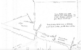
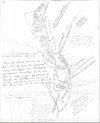
Thanks for your useful posts and maps. I have finally had a chance to look at the maps carefully and have a few comments:
1. On the 1813 Benjamin Cooper survey, the road that you suggest might be "Pestleton? Road" appears to me to read "Pestons Road." I downloaded a copy of this survey from the New Jersey Archives "Early Land Records" database, enlarged it as much as I could and, although the very faded text is admittedly hard to read, it certainly appears to read "Pestons Road." It is also leads directly in the direction of Sebastian Woos' land that lies to the east of the eastern side of the survey area. That would again support my theory that Pestletown is derived from Peston and that Peston was a name for Sebastian Woos. You also note the road "Clem Dicksons? Road," and that is how I read it as well. Clement "Clem" Dickson was a son-in-law of Sebastian Woos who purchased some of Sebastian's former land from Sebastian's widow Mary in 1802. So the direction of that road fits as well.
2. On one of the 1772 survey maps of John West's sawmill related land showing the location of Sebastian Woos' house, you have superimposed the
1886 USGS topo map. It is an excellent idea, and a very useful way to orient the earlier survey. However, it is in error in its placement of Sebastian's house. His house, aka Shane's Castle, is shown on the 1761 survey that I attached to my post #12. Based on its location on that survey and matching that 100-acre tract with later surveys, I am quite certain that the site of Shane's Castle was west of Pestletown Road both in 1886, as well as today since that road remains in the same location.
3. There are a couple of distinctively shaped geographic references that are very useful for orienting and aligning older surveys of the Pestletown area with newer ones for the purpose of superposing them on each other. I refer to these references as "the notch" and "the arrowhead." In the 1884 survey of Mary Neild's land in Pestletown that I have attached first below you can clearly see the triangular tract of land that I call "the arrowhead" on the left, and "the notch" which is at the top of the base of "the arrowhead." They also can be clearly seen in the 1942 tax map that RednekF350 posted in his post #11. And, if you zoom in on the Pestletown area, they are also clearly visible in current GIS plat maps that you can find online at, for example, NJ-GeoWeb (https://www.arcgis.com/apps/webappviewer/index.html?id=02251e521d97454aabadfd8cf168e44d). You can even see "the notch" in the 1813 Cooper survey at the location where "Pestons Road" peters out at the eastern edge of the surveyed area. It is by using this kind of matching up of surveys that I was able to locate the same 1761 tract of land that shows Shane's Castle and confirm that it was west of Pestletown Road (see the second attached survey map below (of 1833) showing the land of Sebastian Woos' son-in-law Eli Neild who became of the owner of all of Sebastian's land north of Clark Branch by the early 1800s. It shows "the arrowhead" ("the notch" is not visible due to the scale) as well as three of Sebastian's former parcels including the one of 100 acres that had Shane's Castle on it in 1761 (on the 1833 Eli Neild survey that tract appears to be labeled Liber E-244 if you can zoom in enough to read it, though it is actually I-244).
4. As for the warrant above that names a Pestons Neck, I need to try to get my hands on the associated survey to see where it places Pestons Neck. Sebastian Woos did have a 70 1/2 acre tract of land up near Price's Branch and this may be referencing something related to that parcel.
Note: both the attached surveys are from John Clement's books of maps and surveys at WestJerseyHistory.org.
Attachments
How ‘bout Goshen Neck?
 forums.njpinebarrens.com
It is easy to overlook the eighteenth century cultural landscape. In the early Pines there’s at least two Hells Necks, Canute Neck, Little Canute Neck, Broad Neck, Hoop-Pole Neck, Squankum Neck, Hammock Neck, Faraway Neck, Stephen[sons] Neck (by Boyd’s)…
Babcock Neck is Shingle Landing (Ilifftown, now Mays Landing). Upstream along Babcock Creek West on the draft map I’ve assembled are Great Neck, Luckey Neck, Betts Neck, and Reeds Neck—all commemorating early settlers. Peachys could, for instance, be referred to as Peachys Neck, for the Peachy family at Peachy Pond spung (later Carmantown), although I have yet to find such.

S-M
Goshen in Camden or Burlington?
That's great that you get out there with your son. Does he like doing the explore? Yes. A couple of our spots to explore were ones he picked out. My daughter does too and goes most of the time too.
It is easy to overlook the eighteenth century cultural landscape. In the early Pines there’s at least two Hells Necks, Canute Neck, Little Canute Neck, Broad Neck, Hoop-Pole Neck, Squankum Neck, Hammock Neck, Faraway Neck, Stephen[sons] Neck (by Boyd’s)…
Babcock Neck is Shingle Landing (Ilifftown, now Mays Landing). Upstream along Babcock Creek West on the draft map I’ve assembled are Great Neck, Luckey Neck, Betts Neck, and Reeds Neck—all commemorating early settlers. Peachys could, for instance, be referred to as Peachys Neck, for the Peachy family at Peachy Pond spung (later Carmantown), although I have yet to find such.
S-M
I just ordered a copy of the Samuel Richards warrant that you quote above to see the location of Pestons Neck on the survey. I will share it here once I get it.How ‘bout Goshen Neck?
Goshen in Camden or Burlington?
That's great that you get out there with your son. Does he like doing the explore? Yes. A couple of our spots to explore were ones he picked out. My daughter does too and goes most of the time too.
It is easy to overlook the eighteenth century cultural landscape. In the early Pines there’s at least two Hells Necks, Canute Neck, Little Canute Neck, Broad Neck, Hoop-Pole Neck, Squankum Neck, Hammock Neck, Faraway Neck, Stephen[sons] Neck (by Boyd’s)…
Babcock Neck is Shingle Landing (Ilifftown, now Mays Landing). Upstream along Babcock Creek West on the draft map I’ve assembled are Great Neck, Luckey Neck, Betts Neck, and Reeds Neck—all commemorating early settlers. Peachys could, for instance, be referred to as Peachys Neck, for the Peachy family at Peachy Pond spung (later Carmantown), although I have yet to find such.
S-M
Cemetery in the woods.
West of the bend on Pestletown Road.
40x145 plot bordered on all corners by Cedars.
Guilty as charged.
Mic Drop
g
West of the bend on Pestletown Road.
40x145 plot bordered on all corners by Cedars.
Guilty as charged.
Mic Drop
g
Thanks RenekF350. When I could not find the marker on Street View anywhere along Pestleton/Pestletown Road or even along a bit of Chew Rd. I wondered whether the sign had long since disappeared or whether it had been placed in the wrong location (though the NJ Historical Commission description implies that it was once in about the right place). I should email them and tell them it is missing and apparently has been for a very long time.
I've been following along with this thread - this is all very interesting stuff and great research. I do not have a lot to contribute here, but I thought I could at least easily get a line out to the NJHC asking about the status of the historical marker. I got a response today:
Thank you for reaching out to us!
At the time of our last audit of the state historical markers - which admittedly was back in 2001 - the Shane’s Castle marker was not noted as missing. However, it is very possible that it has come down in the time since.
We are still waiting to hear if we will receive funding to reinstate the historical marker program in preparation for America’s 250th in 2026. If we do, there would be a process through which community members could nominate old signs for refurbishment/replacement.
If you would like, I can add you to our historical marker interest list, so you will receive a notification if the program is reinstated.
All the best,
Rachel
Rachel Thimke, M. Phil. (she/her)
Programs and Communications Manager
New Jersey Historical Commission
New Jersey Department of State
I followed up to ask if there are any photos, GPS coordinates, notes, etc from the 2001 audit that might provide more context on where it is, or was.
An update - I received the following:
I have been going through our records from the 2001 report, and I’m afraid I haven’t come across any photos or additional notes about the Shane’s Castle marker.
One thing that does strike me as a bit odd though is the note in the spreadsheet about the marker being near Clark Branch and 15 feet away from the road. Is there any chance that the marker is located in the Waterford Memorial Park Cemetery?
Either way, I will be happy to add you to our historical marker interest list and will keep you updated if I find any additional information in our files.
All the best,
Rachel
Nice of her to respond!An update - I received the following:
Anything within 15' of the road would be long gone now. The Pestletown Road stream crossing of Clark's Branch was completely reconstructed about15 years ago. The road was widened and the brush and trees were removed for at least 20 feet from the new edge of the road on the west side and maybe 15 feet on the east side.An update - I received the following:
Here is a 2013 image when the work was new.
Attachments
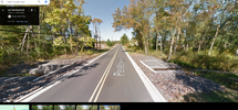
I hope they put some type of barrier up as well by now. Imagine someone unfamiliar with the area pulling into what they perceive as a clearing on a stormy night.Anything within 15' of the road would be long gone now. The Pestletown Road stream crossing of Clark's Branch was completely reconstructed about15 years ago. The road was widened and the brush and trees were removed for at least 20 feet from the new edge of the road on the west side and maybe 15 feet on the east side.
Here is a 2013 image when the work was new.
Largo,Cemetery in the woods.
West of the bend on Pestletown Road.
40x145 plot bordered on all corners by Cedars.
Guilty as charged.
Mic Drop
g
Sorry to take so long to reply. I have been out-of-pocket traveling. There seems to be no doubt that there is an old family cemetery in the rear of your property. As I noted above, I intend to start a new thread in the next couple of weeks that lays out my evidence and rationale for believing that this is the "lost" Woos family burial place mentioned in various 19th century histories. My research initially had me believing that it was at the location of Waterford Memorial Park, but as I compiled more evidence I came to believe that is not the case. The abandoned cemetery in your backyard seems much more plausible as I will argue in my future post.
Piney Roots
I may also reach out to the Camden County History Alliance which, according to the Camden County Historical Society website, "was established in February 2016...as an association of over 50 Camden County history organizations, historic assets, and support agencies,... created to identify resources, increase the number of visitors, and institute projects that promote Camden County heritage." If anything they should have an interest in keeping track of and, when necessary, replacing NJ State Historical Commission markers in Camden County. They also have started their own historical marker project (https://cchsnj.org/alliance-markers/), and might consider the Shane's Castle site or Pestletown in general as a worthy location for a future marker.I've been following along with this thread - this is all very interesting stuff and great research. I do not have a lot to contribute here, but I thought I could at least easily get a line out to the NJHC asking about the status of the historical marker. I got a response today:
I followed up to ask if there are any photos, GPS coordinates, notes, etc from the 2001 audit that might provide more context on where it is, or was.
No barriers were added Bob. No one has ever gone over the sides before or after the improvements were made in the 40 year I have lived here.I hope they put some type of barrier up as well by now. Imagine someone unfamiliar with the area pulling into what they perceive as a clearing on a stormy night.
No guard rails makes for better drivers.
Good news - it looks like the state marker program has been revived with new funding:
It would be good to join one of these and potentially suggest that the Pestletown marker (and any other markers those here know to be missing or in bad shape) should be replaced. I assume as part of the process, someone would come out and attempt to locate the original one.
I am following up on our conversation this summer about the state’s historical marker program.
I am happy to report that we have received funding and will be relaunching the program in early 2025. To help us develop the program, we will be holding three community input meetings throughout November:
November 12, 2024
6:30 – 7:30pm
Camden County Historical Society
November 18, 2024
6:30 – 7:30pm
Virtual
Register for the zoom link
November 23
12:00 - 1:30pm
Paterson Public Library
Co-hosted with Dense Magazine
More information on the relaunched program can also be found at: https://nj.gov/state/historical/historical-markers.shtml.
Thank you again for your interest in the historical marker program. If you have any questions, please let me know.
All the best,
Rachel
It would be good to join one of these and potentially suggest that the Pestletown marker (and any other markers those here know to be missing or in bad shape) should be replaced. I assume as part of the process, someone would come out and attempt to locate the original one.