I think this map is much more accurate as to the physical barrens.The county down here seems to change once you cross west of the Cohansey.The ground becomes richer and more of the land is given over to farming on a large scale.Seabrooks and Roadstown look nothing like Leesburg and Laurel lake.Thgere is a lens of barren habitat centering on Allowy and the county line.Don't know if that reflects a lens of sand or not but you'd think you were back in an oak doninated barrene like whats around Washington.Here's the map published in Howard Boyd's book, mentioned above.


Pointing to Folsom
- Thread starter geezerfinneran
- Start date
You are using an out of date browser. It may not display this or other websites correctly.
You should upgrade or use an alternative browser.
You should upgrade or use an alternative browser.

Pine trees out perform all other tree species on sandy ground. Find a sand patch, and pines are likely to predominate. Sandy deposits are scattered all across the Inner and Outer Coastal Plains, often forming caps atop hills (e.g., Snow Hill, Sugar Hill).
By geologic definition, a Barren is:
Here's a couple excerpts to demonstrate the high resolution of McCormick & Andreson (1963):

I provide a link to an earlier thread –
By geologic definition, a Barren is:
"A word, usually used in the plural, for rugged and unproductive land that is devoid of significant vegetation compared to adjacent areas because of environmental factors such as adverse climate, poor soil, or wind" (Neuendorf et al., 2005: 54, Glossary of Geology).
I think McCormick & Andreson's (1963) map does justice to the topic. The botanists limited "Pine Barrens" to larger tracts, but recognized barrens-like transitional zones and the Virginia pine patch outside Millville. Places like Vineland and Hammonton were once desolate Pine Barrens before railroad-era settlement.Here's a couple excerpts to demonstrate the high resolution of McCormick & Andreson (1963):
I provide a link to an earlier thread –
S-MThanks Spung Man
according to these maps I am squarely in the barrens,While Whipoorbill is not.This makes me so happy") There is an awesome pine barren straddling 55 between sherman ave and landis ave but about ten years ago they chopped it up for paper.There is more west of the river not visible from the highway,also all the woods where cumberland crossing is now used to be barrens with maybe a third of it remaining behind the stores.Used to see pine snakes back there before they put shop rite on top of their den.
There is an awesome pine barren straddling 55 between sherman ave and landis ave but about ten years ago they chopped it up for paper.There is more west of the river not visible from the highway,also all the woods where cumberland crossing is now used to be barrens with maybe a third of it remaining behind the stores.Used to see pine snakes back there before they put shop rite on top of their den.
according to these maps I am squarely in the barrens,While Whipoorbill is not.This makes me so happy
There is an awesome pine barren straddling 55 between sherman ave and landis ave but about ten years ago they chopped it up for paper.There is more west of the river not visible from the highway,also all the woods where cumberland crossing is now used to be barrens with maybe a third of it remaining behind the stores.Used to see pine snakes back there before they put shop rite on top of their den.Manumuskin,
That area is an ancient riverine dune field. Those are Pleistocene parabolic dune arms composed of loose windblown sugar sands along Route 55, hence the classic Pine Barrens feel.

It is critical habitat but that is the last thing the developers and their allies wish to hear.
S-M
Walsh D. 2006. “Millville development fight goes back to the beginning: development on the Union Lake tract would spoil its geological and archaeological value, experts say.” The Press of Atlantic City. MMVI, 51: A1, A6.
That area is an ancient riverine dune field. Those are Pleistocene parabolic dune arms composed of loose windblown sugar sands along Route 55, hence the classic Pine Barrens feel.
It is critical habitat but that is the last thing the developers and their allies wish to hear.
S-M
Walsh D. 2006. “Millville development fight goes back to the beginning: development on the Union Lake tract would spoil its geological and archaeological value, experts say.” The Press of Atlantic City. MMVI, 51: A1, A6.
Development on the Union Lake tract would spoil its geological and archaeological value, experts say. This is where Millville started. Three hundred years ago, it was called Union Mills, a tiny settlement built where a major Indian trail passed by the Maurice River. Today, it's just the Union Lake tract, where 400 acres of unspoiled land will likely be bulldozed, depending on a Planning Board decision that could come at a meeting March 13. Neighbors have fought...
Hajna LR 2006. “Naturalist makes case for Pinelands dunes.” Courier Post: South Jersey’s Newspaper. September 30, 1B, 6B. Take a drive through the Pinelands with Mark Demitroff. Where most people would see long stretches of monotonous woodlands or barely noticeable undulations in roads, he sees dune systems with comet-like tails fanning out along ancient river valleys. Better yet, take a hike with Demitroff along a Pinelands trail. He'll make a convincing case that what you thought were merely heaps of white sand are actually inland dunes, remnants of a time when hostile winds blew off glaciers…
I knew it was the sand that made the barrens all along! Pitch Pine can't stand good soil,it's too tough for that sissy stuff.
That 1963 data is nice, thanks for posting. This has turned into a good discussion (with perhaps one exception ") ), although it's getting pretty far from the original question.
), although it's getting pretty far from the original question.
NJDEP maintains a very high resolution database of landcover data at 1:12,000 scale (that's 4x the resolution of a 24k map), most recently updated in 2007. http://www.state.nj.us/dep/gis/lulc07cshp.html
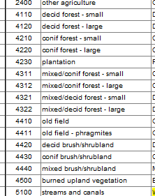
It uses the Anderson system, where a numeric code describes the landcover/land use for each area mapped - here's a very small snip
I've used this in my 2012 map of NJ to produce forest shading as well as my Landscape of New Jersey project: http://www.gpsfiledepot.com/maps/view/441/
So I just grabbed my source files, selected all the coniferous dominant areas and colored them bright green in the map below, which covers an area similar to Mark's 1963 map. I've included large and small coniferous forests, coniferous dominant mixed forests, coniferous scrub and cedar wetlands in these areas.The pale green areas are primarily deciduous forests. The data doesn't include soil type, only landcover.

I think I can still see the elliptical area near Alloway that appears on the 1963 map. Here's a closer view

), although it's getting pretty far from the original question.NJDEP maintains a very high resolution database of landcover data at 1:12,000 scale (that's 4x the resolution of a 24k map), most recently updated in 2007. http://www.state.nj.us/dep/gis/lulc07cshp.html
It uses the Anderson system, where a numeric code describes the landcover/land use for each area mapped - here's a very small snip
I've used this in my 2012 map of NJ to produce forest shading as well as my Landscape of New Jersey project: http://www.gpsfiledepot.com/maps/view/441/
So I just grabbed my source files, selected all the coniferous dominant areas and colored them bright green in the map below, which covers an area similar to Mark's 1963 map. I've included large and small coniferous forests, coniferous dominant mixed forests, coniferous scrub and cedar wetlands in these areas.The pale green areas are primarily deciduous forests. The data doesn't include soil type, only landcover.
I think I can still see the elliptical area near Alloway that appears on the 1963 map. Here's a closer view