I'm not sure what you are showing there. I don't see anything but the 1930 aerial.I don't know about that Bob. Go here and look NE and SW and there are multiple lines with monuments on each that I have found.

Property Stones And More... Fall 2022/ Winter Spring 2023
- Thread starter Teegate
- Start date
You are using an out of date browser. It may not display this or other websites correctly.
You should upgrade or use an alternative browser.
You should upgrade or use an alternative browser.
That is a very interesting area at Saltar’s Ditch. Photographed the same area a couple years ago. Tested the board by carefully crossing it and saw the structure as well. Seems to be very old with all the roots intertwined through it. One of my favorite areas to explore, especially in winter. Need to get back out there!This morning I headed to the south side of Atsion lake in the far back looking for one of the Princeton cedar swamp study area's. I did not find anything at the location I was looking. I did get to the back of the lake though.
View attachment 19076
Usually I walk the road where it crosses Salters Ditch but today I noticed this board across the creek and took that route. While crossing it I noticed an old dam or foundation for a bridge in the ditch so I sat on the board and took a photo of the structure.
The board.
View attachment 19077
The structure. I have walked by this for years and never saw it.
View attachment 19078
From the back showing both structure and board.
View attachment 19079
I then headed to Friendship Bogs to revisit a monument I found many years ago and can't find my photos. I wanted to check if it was still there as it was close to falling in the culvert.
View attachment 19080

The same map that Spung-man posted showing the Goshen area also shows the location of various property stones around the barrens. This one shows the location of the I (eye) C stone of Israel Chew from Chewtown on Chew road. Using the various information I have accumulated over the years I was able to figure out the location this stone would be located at. I know the survey line, but I don't know exactly where along that line it was located. However, the map tells us that the blue line is the old road running along the stream and if the map is correct the stone would be near the road.

So first thing this morning Jessica and I spent a half hour walking the line along the road and further from the road and came up empty. It is just one large patch of briers in one location but I walked it anyway and drew quite a bit of blood. Jessica stayed for the most part along the dim road directing me. In reality it is now a trail but you can see at one time this road was a major one.
From there we headed to another location along the Tusco Musco branch where these two stone are located. The one on the left is 33 feet East of Evans road and both of them are south of the Tusco Musco. Even though it looks like the one on the right is inscribed N C E the fact is I have other information that says differently. The letters are actually N C T E with the T and the E connected on the map and maybe the stone itself. Notice that below.

It took me a while to even figure out where the proper location of the Tusco Musco was so I contacted Jerseyman to have him confirm I was at the proper location. He agreed so after our adventure above we headed there and walked Evans road. Jessica discovered a cell phone trail camera along the road so the owners got a few good shots of my face staring at it. I then walked 33 feet or so East of the road and again came up empty.
While standing in the road Jessica saw someone coming towards us on an e-bike but they turned and went to our right. We were going left so we headed down to where they were and headed left looking for the incised stone. After a half mile walk we discover these just laying there with nobody around.

We continued on and then we noticed them. Coming towards us with their guns over their shoulder we came face to face with hunters. I asked them if we interrupted them and he answered yes. He did not seem happy with us. We continued on and scoped out the area and I will be returning again to look for the stone. On the way back we saw them passing through the woods on bikes and ran into them loading them into their truck. They avoided looking at us and so we ignored them as well. I guess they figured nobody would be out there and we disappointed them.
So first thing this morning Jessica and I spent a half hour walking the line along the road and further from the road and came up empty. It is just one large patch of briers in one location but I walked it anyway and drew quite a bit of blood. Jessica stayed for the most part along the dim road directing me. In reality it is now a trail but you can see at one time this road was a major one.
From there we headed to another location along the Tusco Musco branch where these two stone are located. The one on the left is 33 feet East of Evans road and both of them are south of the Tusco Musco. Even though it looks like the one on the right is inscribed N C E the fact is I have other information that says differently. The letters are actually N C T E with the T and the E connected on the map and maybe the stone itself. Notice that below.
It took me a while to even figure out where the proper location of the Tusco Musco was so I contacted Jerseyman to have him confirm I was at the proper location. He agreed so after our adventure above we headed there and walked Evans road. Jessica discovered a cell phone trail camera along the road so the owners got a few good shots of my face staring at it. I then walked 33 feet or so East of the road and again came up empty.
While standing in the road Jessica saw someone coming towards us on an e-bike but they turned and went to our right. We were going left so we headed down to where they were and headed left looking for the incised stone. After a half mile walk we discover these just laying there with nobody around.
We continued on and then we noticed them. Coming towards us with their guns over their shoulder we came face to face with hunters. I asked them if we interrupted them and he answered yes. He did not seem happy with us. We continued on and scoped out the area and I will be returning again to look for the stone. On the way back we saw them passing through the woods on bikes and ran into them loading them into their truck. They avoided looking at us and so we ignored them as well. I guess they figured nobody would be out there and we disappointed them.
These are true motorcycles, not the "engine" motorcycles most are familiar with. How long before complaints begin from other forest users about these stealthy machines? Are there any regulations concerning them as there are for traditional motorcycles?
That was yesterday Gibby.Sunday hunting in a state forest? I didn't think regulations allowed it.
Hahaha! Thanks Bob. I overlooked the post date and was just glancing over the responses. It makes more sense now.That was yesterday Gibby.
Hope you have better luck next time! Never know what you’re going to run into. Looking forward to the next update.The same map that Spung-man posted showing the Goshen area also shows the location of various property stones around the barrens. This one shows the location of the I (eye) C stone of Israel Chew from Chewtown on Chew road. Using the various information I have accumulated over the years I was able to figure out the location this stone would be located at. I know the survey line, but I don't know exactly where along that line it was located. However, the map tells us that the blue line is the old road running along the stream and if the map is correct the stone would be near the road.
View attachment 19275
So first thing this morning Jessica and I spent a half hour walking the line along the road and further from the road and came up empty. It is just one large patch of briers in one location but I walked it anyway and drew quite a bit of blood. Jessica stayed for the most part along the dim road directing me. In reality it is now a trail but you can see at one time this road was a major one.
From there we headed to another location along the Tusco Musco branch where these two stone are located. The one on the left is 33 feet East of Evans road and both of them are south of the Tusco Musco. Even though it looks like the one on the right is inscribed N C E the fact is I have other information that says differently. The letters are actually N C T E with the T and the E connected on the map and maybe the stone itself. Notice that below.
View attachment 19276
It took me a while to even figure out where the proper location of the Tusco Musco was so I contacted Jerseyman to have him confirm I was at the proper location. He agreed so after our adventure above we headed there and walked Evans road. Jessica discovered a cell phone trail camera along the road so the owners got a few good shots of my face staring at it. I then walked 33 feet or so East of the road and again came up empty.
While standing in the road Jessica saw someone coming towards us on an e-bike but they turned and went to our right. We were going left so we headed down to where they were and headed left looking for the incised stone. After a half mile walk we discover these just laying there with nobody around.
View attachment 19277
We continued on and then we noticed them. Coming towards us with their guns over their shoulder we came face to face with hunters. I asked them if we interrupted them and he answered yes. He did not seem happy with us. We continued on and scoped out the area and I will be returning again to look for the stone. On the way back we saw them passing through the woods on bikes and ran into them loading them into their truck. They avoided looking at us and so we ignored them as well. I guess they figured nobody would be out there and we disappointed them.
When does a bicycle turn into a motorcycle? I was in Ocean City last summer and saw a dude riding an electric bicycle driving down the road at 35 mph towing a trailer. He wasn't wearing a helmet and weaved through the traffic at car speeds.
I not a fan of regulation but I found it ironic that a moped has to be registered and insured and the driver must have a valid license.
I not a fan of regulation but I found it ironic that a moped has to be registered and insured and the driver must have a valid license.
I think it's just a matter of time, regulations [laws] have not caught up to recent technology. Same for E- auto, when are they going to start paying for the roads?When does a bicycle turn into a motorcycle? I was in Ocean City last summer and saw a dude riding an electric bicycle driving down the road at 35 mph towing a trailer. He wasn't wearing a helmet and weaved through the traffic at car speeds.
I not a fan of regulation but I found it ironic that a moped has to be registered and insured and the driver must have a valid license.
Revisted a few locations today to clear up some questions I had concerning my records. This photo shows Jessica VERY NEAR the same location 15 years ago and today. We are at Goshen Gap. It is most likely not the exact spot. Anyway, she has the same coat on.

We returned to the Goshen Gap area today to search for stones and look for the glove I lost last weekend. We came up empty with stones but by following my GPS track we found my glove. Along the way we ran into this on a motorcycle trail. I would say it is at least 10 years old and maybe much more.


I found this hidden in some laurel.

And with various places such as Delaware Water Gap having the "Gap" name I would think that Goshen Gap is named because of the large and deep canal (gap) that cuts right though the area. What is your opinion?


And ignore the Then And Now in the post above. We again found the proper location.

I found this hidden in some laurel.
And with various places such as Delaware Water Gap having the "Gap" name I would think that Goshen Gap is named because of the large and deep canal (gap) that cuts right though the area. What is your opinion?
And ignore the Then And Now in the post above. We again found the proper location.
All,
I really enjoy exploring in the woods around Goshaen Gap so we spent another day there walking and looking for property stones. If you remember in a recent post I mentioned we found a game camera set up at an unlikely spot. It is facing a small clearing that has a motorcycle intersection in it and I was thinking maybe they were watching them. I still don't really know why it is at that spot but I will continue to investigate.
So about a half mile away we stumbled on this one along a path in the woods pointing into the woods that really has nothing to show them. I found it really odd. This one is a phone camera where they can check their photos. They are going to be surprised!

The camera is slightly facing down so I stood at the camera and looked where it was pointing and I did not see anything. So I walked around and noticed this.


I have to assume it is a snare. What are the rules concerning snares? Do they physically have to check them everyday or is this camera sufficient? And can they still be trapping now?
Later, we returned to the other camera and I spent some time looking and I just can't see how that camera could have a snare at the location it is pointing at. If you had a snare would you have it at an intersection where motorcycles travel, or have one right along a motorcycle trail? Imagine a motorcycle coming along and finding an animal caught in it. There are too many other places to put a snare my opinion.
Anyway, we visited this spung today. It could have some basic plants so we will check it in the summer again. It looks like it was plowed through after 1984 but before 1995. The plow line goes right through it.

And we found a William Braddock property stone along the bogs nearby. Actually, I have not found a deed that says a stone was there so I can't really say if it was there when Willam Braddock was alive or owned it. The stone is about a foot underground.


It was really nice early this morning but after a while it looked like rain. I am right along the property line of Wharton.


I have a video coming soon.
Guy
I really enjoy exploring in the woods around Goshaen Gap so we spent another day there walking and looking for property stones. If you remember in a recent post I mentioned we found a game camera set up at an unlikely spot. It is facing a small clearing that has a motorcycle intersection in it and I was thinking maybe they were watching them. I still don't really know why it is at that spot but I will continue to investigate.
So about a half mile away we stumbled on this one along a path in the woods pointing into the woods that really has nothing to show them. I found it really odd. This one is a phone camera where they can check their photos. They are going to be surprised!
The camera is slightly facing down so I stood at the camera and looked where it was pointing and I did not see anything. So I walked around and noticed this.
I have to assume it is a snare. What are the rules concerning snares? Do they physically have to check them everyday or is this camera sufficient? And can they still be trapping now?
Later, we returned to the other camera and I spent some time looking and I just can't see how that camera could have a snare at the location it is pointing at. If you had a snare would you have it at an intersection where motorcycles travel, or have one right along a motorcycle trail? Imagine a motorcycle coming along and finding an animal caught in it. There are too many other places to put a snare my opinion.
Anyway, we visited this spung today. It could have some basic plants so we will check it in the summer again. It looks like it was plowed through after 1984 but before 1995. The plow line goes right through it.
And we found a William Braddock property stone along the bogs nearby. Actually, I have not found a deed that says a stone was there so I can't really say if it was there when Willam Braddock was alive or owned it. The stone is about a foot underground.
It was really nice early this morning but after a while it looked like rain. I am right along the property line of Wharton.
I have a video coming soon.
Guy
Snares are legal for trapping every day from November 15 to March 15 each year, Guy. They have to be physically checked every 24 hours. Cameras don't count.
There should be a brass trap tag on the snare, usually attached to the swivel point.. The tag has to have the CID number of the trapper on it. For some of us old guys, there is a prior numbering system that is still valid. I have an older 3 digit ID. The ID number can be provided to a Conservation Officer if you have a specific complaint and they will contact the trapper. The trapper's actual name is not required to be on the tag to prevent undue harassment from the public. If there is no tag on the snare, that's a violation.
The loop size of the snare is regulated at a max diameter of 12" and a max height from the ground to the top of the snare loop of 24". A loop stop is required in NJ to restrict diameter to 12". The snare also has to have a deer stop that prevents the snare from closing on a deer's hoof.
Last edited:
This brings up a story") My knee has been messed up for a couple months,I"m finally getting an MRI next week,the insurance made me take an xray first which of course just showed arthrits,this isn't arthritis,and I had a choice between cortisone shots and six week course of pills.I chose the pills,cortisone hurts like hell and does absolutely nothing,been there done that. In any case i do have my good days and last week i had a good day and went arrowhead hunting with a couple friends.To make a long story short I was walking a game trail between two fields we hunt in through a patch of honeysuckle that is part of a wooded strip between fields about maybe 70 ft wide.One friend was walking about thirty ft in front of me the other was in the mud doen on the tide flat checking the flat and caves in the bluff for artifacts. All the sudden my right foot got snagged on something (My bad knee is my left knee)Well I yanked to break the honeysuckle and continue walking but the vines or so i thought snatched me up short.Now anybody thats an outdoorsman knows Honeysuckle is weak.You can snap it with your bare hands,It aint ,catbriar for sure.Well when it caught my foot I screamed because it felt like a knife went through my left knee.I yanked again.Again it snatched me tight and i screamed.Third times a charm,same result.I looked down and there was a $%#@&% snare around my right foot.I had to get down and work the thing off.I started to uproot it and fling it as far as I could which I did to a snare that caught my dog once.I looked and there was a tag on it,won't say name or town.I threw it down and gave it a good kick,needless to say i did not reset it.It was attached to a two inch wide sapling,Thirty feet away we saw a bigger snare,this one was set big enough to catch a coyote but kinda low to the ground.If the yote had its head to the ground it might get caught.There is a fox den that is used 100 ft away in the trees next to the bluff down to the crik.I assume maybe they were after the fox.Lot of groundhogs around too but awful big loop for a groundhog head.Dont know how big the one originally was that caught my foot.I wonder if I"m the first man this trapper has ever caught?needless to say there was much mirth at my expense.I now appreciate my hands and fingers much better.
My knee has been messed up for a couple months,I"m finally getting an MRI next week,the insurance made me take an xray first which of course just showed arthrits,this isn't arthritis,and I had a choice between cortisone shots and six week course of pills.I chose the pills,cortisone hurts like hell and does absolutely nothing,been there done that. In any case i do have my good days and last week i had a good day and went arrowhead hunting with a couple friends.To make a long story short I was walking a game trail between two fields we hunt in through a patch of honeysuckle that is part of a wooded strip between fields about maybe 70 ft wide.One friend was walking about thirty ft in front of me the other was in the mud doen on the tide flat checking the flat and caves in the bluff for artifacts. All the sudden my right foot got snagged on something (My bad knee is my left knee)Well I yanked to break the honeysuckle and continue walking but the vines or so i thought snatched me up short.Now anybody thats an outdoorsman knows Honeysuckle is weak.You can snap it with your bare hands,It aint ,catbriar for sure.Well when it caught my foot I screamed because it felt like a knife went through my left knee.I yanked again.Again it snatched me tight and i screamed.Third times a charm,same result.I looked down and there was a $%#@&% snare around my right foot.I had to get down and work the thing off.I started to uproot it and fling it as far as I could which I did to a snare that caught my dog once.I looked and there was a tag on it,won't say name or town.I threw it down and gave it a good kick,needless to say i did not reset it.It was attached to a two inch wide sapling,Thirty feet away we saw a bigger snare,this one was set big enough to catch a coyote but kinda low to the ground.If the yote had its head to the ground it might get caught.There is a fox den that is used 100 ft away in the trees next to the bluff down to the crik.I assume maybe they were after the fox.Lot of groundhogs around too but awful big loop for a groundhog head.Dont know how big the one originally was that caught my foot.I wonder if I"m the first man this trapper has ever caught?needless to say there was much mirth at my expense.I now appreciate my hands and fingers much better.
My knee has been messed up for a couple months,I"m finally getting an MRI next week,the insurance made me take an xray first which of course just showed arthrits,this isn't arthritis,and I had a choice between cortisone shots and six week course of pills.I chose the pills,cortisone hurts like hell and does absolutely nothing,been there done that. In any case i do have my good days and last week i had a good day and went arrowhead hunting with a couple friends.To make a long story short I was walking a game trail between two fields we hunt in through a patch of honeysuckle that is part of a wooded strip between fields about maybe 70 ft wide.One friend was walking about thirty ft in front of me the other was in the mud doen on the tide flat checking the flat and caves in the bluff for artifacts. All the sudden my right foot got snagged on something (My bad knee is my left knee)Well I yanked to break the honeysuckle and continue walking but the vines or so i thought snatched me up short.Now anybody thats an outdoorsman knows Honeysuckle is weak.You can snap it with your bare hands,It aint ,catbriar for sure.Well when it caught my foot I screamed because it felt like a knife went through my left knee.I yanked again.Again it snatched me tight and i screamed.Third times a charm,same result.I looked down and there was a $%#@&% snare around my right foot.I had to get down and work the thing off.I started to uproot it and fling it as far as I could which I did to a snare that caught my dog once.I looked and there was a tag on it,won't say name or town.I threw it down and gave it a good kick,needless to say i did not reset it.It was attached to a two inch wide sapling,Thirty feet away we saw a bigger snare,this one was set big enough to catch a coyote but kinda low to the ground.If the yote had its head to the ground it might get caught.There is a fox den that is used 100 ft away in the trees next to the bluff down to the crik.I assume maybe they were after the fox.Lot of groundhogs around too but awful big loop for a groundhog head.Dont know how big the one originally was that caught my foot.I wonder if I"m the first man this trapper has ever caught?needless to say there was much mirth at my expense.I now appreciate my hands and fingers much better.Snares are legal for trapping every day from November 15 to March 15 each year, Guy. They have to be physically checked every 24 hours. Cameras don't count.
There should be a brass trap tag on the snare, usually attached to the swivel point.. The tag has to have the CID number of the trapper on it. For some of us old guys, there is a prior numbering system that is still valid. I have an older 3 digit ID. The ID number can be provided to a Conservation Officer if you have a specific complaint and they will contact the trapper. The trapper's actual name is not required to be on the tag to prevent undue harassment from the public. If there is no tag on the snare, that's a violation.
The loop size of the snare is regulated at a max diameter of 12" and a max height from the ground to the top of the snare loop of 24". A loop stop is required in NJ to restrict diameter to 12". The snare also has to have a deer stop that prevents the snare from closing on a deer's hoof.
It is not easy to get to this camera. The person would need a motorcycle or to walk a fairly long distance. Let say they traveled Jackson road every day to and from work they would have to drive a dirt road for 5 full minutes and walk for 10 to get there. Then to return to Jackson it would again be 15 minutes. So 30 minutes minumum each day would be involved checking it.
And to be honest the snare looks like it is not even working and I cleaned off the camera to view it because it had vegetation all on it. And the snare is mostly under leaves and pine needles. The only part above ground is what you see in my photo.
Yes, your photos show that the snare is not set. I see a support wire wrapped around the snare and I see no formed loop.It is not easy to get to this camera. The person would need a motorcycle or to walk a fairly long distance. Let say they traveled Jackson road every day to and from work they would have to drive a dirt road for 5 full minutes and walk for 10 to get there. Then to return to Jackson it would again be 15 minutes. So 30 minutes minumum each day would be involved checking it.
And to be honest the snare looks like it is not even working and I cleaned off the camera to view it because it had vegetation all on it. And the snare is mostly under leaves and pine needles. The only part above ground is what you see in my photo.
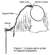
Here is a detail of what a set snare would look like. Loop size and loop height are set differently for various animals.
A 30-40 minute roundtrip for a line check is not unusual. That is what I always had when I set off of Chew Road. I would go right from work every night and in January, your are going in and coming out in the dark.