Raised trail?

Apr 6, 2004
3,613
556
Galloway
Seriously though, it makes me happy to know that deep within the Pine Barrens it still remains the same.

Below - Pine Branch Creek 22 Sep 1971.

pinelandpaddler - I too used to be a pineland paddler. Unfortunately I can't figure out a way to make that rhyme with green ham. If I could I would, Pan I am!​


Tell me now, where's Pine Branch Creek?
Where does it hide? Where shall I seek?
Tell me now, if you can.
Tell me now, Pan-I-Am!
 
  • Like
Reactions: bobpbx

DashRyan

Scout
Nov 5, 2022
77
41
Toms river
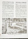
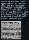
I hit the Toms River Library last week, thinking there may be something there. I found this book in the reference area. It has a lot of information on dover forge, mostly on nearby Hollowfield Cemetery. 20231113_190951.jpg20231113_190601.jpg
 
  • Like
Reactions: Boyd

bobpbx

Piney
Staff member
Oct 25, 2002
14,239
4,331
Pines; Bamber area
Here, I'm standing at the bottom of the slope, and I noted there was a channel sweeping straight over to the large canal as shown on the lidar. I've outlined it, but so many years have gone by that its almost obliterated due to accumulating detritus.
1700267548488.png
 
  • Like
Reactions: DashRyan

Pan

Explorer
Jul 4, 2011
555
246
Arizona
Tell me now, where's Pine Branch Creek?
Where does it hide? Where shall I seek?
Tell me now, if you can.
Tell me now, Pan-I-Am!

Pineland-P,
Pine Branch C is hard to find,
I'm in a bind
It slips my mind.

It seems to be situated by a hamlet called "Blackwood Ter", which must stand for Terrace, I guess, but u never know in New Jersey. It's not like we're talking about a civilized place. They actually play golf in New Jersey (see below)...

"There are also plenty of outdoor activities here [Blackwood Ter] all year round such as fishing at Bowe’s Creek Nature Park, golfing at Deer Valley Golf Course and canoeing down the Pine Branch Creek..."

 
Last edited:

Pan

Explorer
Jul 4, 2011
555
246
Arizona
There is a Trail
In a State Park
In Southern New Jersey....

And it's been the site of strange phenomena, like shadows of things that don't exist... :ninja:


I used to go on century rides - 100 mile bicycle rides - starting in - I forgot the name of that nice town in central NJ - and going into PA. Once I went up a long hill, as I recall, to a town named Zion in NJ. I felt like I had entered the Twilight Zone. I saw robotic people walking stiffly and staring straight ahead. I've had some other strange outdoor adventures in NJ and NY. Once I met two real witches. Where's that trail?
 

bobpbx

Piney
Staff member
Oct 25, 2002
14,239
4,331
Pines; Bamber area
I'd like to do a sort of test with one of my photos. When I reached the bottom of the slope, I looked back up at the berm and took a photo of the berm at the top. When I looked at the photo after uploading it I said to myself "I"m not going to show this one, they won't get it, it just looks like woods because cameras are basically 2 dimensional". But what if I outlined the berm at the top along with the ground around it. I'm curious if you now construct the slope in your mind after seeing this:

1700320568680.png
 
  • Like
Reactions: Boyd and DashRyan

DashRyan

Scout
Nov 5, 2022
77
41
Toms river
I'd like to do a sort of test with one of my photos. When I reached the bottom of the slope, I looked back up at the berm and took a photo of the berm at the top. When I looked at the photo after uploading it I said to myself "I"m not going to show this one, they won't get it, it just looks like woods because cameras are basically 2 dimensional". But what if I outlined the berm at the top along with the ground around it. I'm curious if you now construct the slope in your mind after seeing this:

View attachment 21266
Yes. That helps. I was going to do the same thing, but I waited until I left to try it.
 
  • Like
Reactions: bobpbx

DashRyan

Scout
Nov 5, 2022
77
41
Toms river
Good questions. My best guess right now is that it was an access road to reach the river downstream from the cranberry bog for some reason. Perhaps to collect spill from flooding/ draining the bogs.
 
Apr 6, 2004
3,613
556
Galloway
Good questions. My best guess right now is that it was an access road to reach the river downstream from the cranberry bog for some reason. Perhaps to collect spill from flooding/ draining the bogs.
All the other roads in the area are cut into the ground, not raised on a berm. I'd rule out a road.
 
  • Like
Reactions: DashRyan

DashRyan

Scout
Nov 5, 2022
77
41
Toms river
All the other roads in the area are cut into the ground, not raised on a berm. I'd rule out a road.
That's what initially brought it to my attention. Only Dover forge trail is raised like it in the area.
The old mill site was being turned into a bog in 1908.
According to the history provided by the Monmouth County Historical Society, the entire area was consumed by a large forest fire in 1910.
 

DashRyan

Scout
Nov 5, 2022
77
41
Toms river
Screenshot_20231214_212800_Chrome.jpg
The fire break in the upper portion of the diagram seems to fit with the raised trail formation and location. Near the blueberry fields, the area has been formerly cultivated. Could this be an old bog, up and away from Cedar Creek? Maybe not a bog at all by dry harvested cranberries?
 
  • Like
Reactions: Boyd
Top