Isn't this a generic diagram of a cranberry bog? Not a specific place?View attachment 21436
The fire break in the upper portion of the diagram seems to fit with the raised trail formation and location. Near the blueberry fields, the area has been formerly cultivated. Could this be an old bog, up and away from Cedar Creek? Maybe not a bog at all by dry harvested cranberries?

Raised trail?
- Thread starter DashRyan
- Start date
You are using an out of date browser. It may not display this or other websites correctly.
You should upgrade or use an alternative browser.
You should upgrade or use an alternative browser.
That's right, no records exist for Dover forge during the sawmill, cranberry era, according to the Double Trouble historian.

I woke up around 3 am last night. So after I get back in bed and after 30 minutes of lying there, drifting off, a thought on this mystery entered my head. I was thinking about how straight that line is, and how low the mound is (what, maybe 18" to 24"?). It was then that the thought came to me; why not an iron pipe? One they just laid on the ground, and as an afterthought, decided to cover it so the water inside would resist freezing. Pipelines, at least those without elbows or 45's or what-not, are bound to be super straight if they are connected correctly.
No? Yes? Maybe?
By the way, thinking of this, I looked at the 1930 aerial again. I don't see the mound after all, so maybe later it was put in. Then again, 1930 is an aerial, not lidar.
I see now Dash, you were on that track of a pipe earlier in this thread. Need to get out there with a shovel.
No? Yes? Maybe?
By the way, thinking of this, I looked at the 1930 aerial again. I don't see the mound after all, so maybe later it was put in. Then again, 1930 is an aerial, not lidar.
I see now Dash, you were on that track of a pipe earlier in this thread. Need to get out there with a shovel.
Last edited:
I definitely Did NOT. LOL.The wall of briar 15 feet in front of the canal following the line that should have been.
View attachment 21228
Me wondering if Dash went through here. Me thinks no.
View attachment 21231
But I did, and reaching the canal, I was sure it was not the spot he photographed.
View attachment 21239
But Dash found a good spot to go in. No struggle at all.
View attachment 21240
It's pretty muddy out there. I was there today when I noticed 2 things.I'm going to do it. Dig.
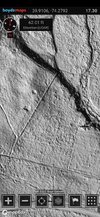
The first being breaks along the line of the raised trail. If you're going to bring a shovel, that might be the place to get down. From the South to North image (Dover rd. being at the bottom of the image) it looks more and more like a property line or boudary.
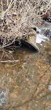
And the second is something that I found over in the Dover Forge area. Sections of Terra cotta or clay pipe that cross the stream. Right on the edge of the recent control burn. It might be a similar sort of pipe you're looking for, if there's pipe to be found.
Attachments
Do you know of any other examples in the Pines?I say property line of some sort.
On Green Grove rd. In Ocean township, Monmouth county there's a similar feature near gun club rd.Do you know of any other examples in the Pines?
On Green Grove rd. In Ocean township, Monmouth county there's a similar feature near gun club rd.


Can you link to the specific location? Would save me some time.
The GPS coordinates are at the top of the photo.Can you link to the specific location? Would save me some time.
Like I said, it would save me and others time were you to simply link to the location. It's a courteous practice.The GPS coordinates are at the top of the photo.
Different animals, Dash.
I was just about to post it.Different animals, Dash.
Are you talkiing about the raised "ridge" feature here? That is about 10 to 15 feet higher than the surrounding terrain, at the edge of a gravel pit.
https://boydsmaps.com/#19.15/40.248287/-74.076207/mbx3dmidatl/12.00/72.00

https://boydsmaps.com/#19.15/40.248287/-74.076207/mbx3dmidatl/12.00/72.00
I am. Its a very similar to the feature we're studying at Dover forge. An earthen property line or fence. With time and erosion, they could be twins.Are you talkiing about the raised "ridge" feature here? That is about 10 to 15 feet higher than the surrounding terrain, at the edge of a gravel pit.
https://boydsmaps.com/#19.15/40.248287/-74.076207/mbx3dmidatl/12.00/72.00
View attachment 22004