Dash, I also poked around there yesterday. I could make out the outline of the right turn, but it was barely noticeable. I left without having any new ideas. Thick woods back there.
Raised trail?
- Thread starter DashRyan
- Start date
You are using an out of date browser. It may not display this or other websites correctly.
You should upgrade or use an alternative browser.
You should upgrade or use an alternative browser.
Indeed. My arms and legs are all scratched up from the thickets.Dash, I also poked around there yesterday. I could make out the outline of the right turn, but it was barely noticeable. I left without having any new ideas. Thick woods back there.
How far did you get, following the right turn?
That might be the sort of smaller feature you could LIDAR scan with a phone if you have a newer one with that capability. For example, look at the second link in my old thread here. Looks like this is only available on the following iPhone models for now, don't think there are any Android phones.
iPhone 14 Pro Max
iPhone 14 Pro
iPhone 13 Pro Max
iPhone 13 Pro
iPhone 12 Pro
iPhone 12 Pro Max
iPad Pro (2020 Version & Later)
iPhone 14 Pro Max
iPhone 14 Pro
iPhone 13 Pro Max
iPhone 13 Pro
iPhone 12 Pro
iPhone 12 Pro Max
iPad Pro (2020 Version & Later)
Last edited:
That is pretty cool.That might be the sort of smaller feature you could LIDAR scan with a phone if you have a newer one with that capability. For example, look at the second example in my old thread here. Looks like this is only available on the following iPhone models for now, don't think there are any Android phones.
iPhone 14 Pro Max
iPhone 14 Pro
iPhone 13 Pro Max
iPhone 13 Pro
iPhone 12 Pro
iPhone 12 Pro Max
iPad Pro (2020 Version & Later)
I received from the archivist at the Monmouth County Historical Society a copy of the 1830 survey of land East of the Dover Tract.


Boyd, would you say that the raised trail is the same height as the dirt road that runs through Dover Forge?
Boyds Map set up measures height. I see the raised area about 5 or 6 feet higher depending upon location.Boyd, would you say that the raised trail is the same height as the dirt road that runs through Dover Forge?
Yes, the elevation at the crosshairs should show at the top left of the screen as you move the mouse around. But the raised trail isn't flat, it slopes up to a "peak" of about 70 feet around here
https://boydsmaps.com/#18.00/39.910566/-74.278710/midatlidar/0.00/0.00

It's about 64 feet at the North end where it meets the road and only 60 feet at the South end (before it drops off into the swamp). Drag the map such that the crosshairs follow the trail and observe how the elevation changes.
I have to ask... do you only have a phone and not a computer? A computer works better for this type of thing. You can also use the terrain viewer (links I posted earlier) to view elevation.
https://boydsmaps.com/#18.00/39.910566/-74.278710/midatlidar/0.00/0.00
It's about 64 feet at the North end where it meets the road and only 60 feet at the South end (before it drops off into the swamp). Drag the map such that the crosshairs follow the trail and observe how the elevation changes.
I have to ask... do you only have a phone and not a computer? A computer works better for this type of thing. You can also use the terrain viewer (links I posted earlier) to view elevation.
The Monmouth County Historical Society records end roughly about the time of the formation of Ocean county, the archivist doesn't have anything past that era in their records. They recommended a deed search for the property with the Ocean County clerks office.Mostly I use my phone, the computer I can use is usually in use.
Thanks for your help with the measurements
I was beginning to think that the raised trail might be a second berm for another bog east of Dover Forge.
Berkeley township
1506_212_1.01
The Monmouth County Historical Society records end roughly about the time of the formation of Ocean county, the archivist doesn't have anything past that era in their records. They recommended a deed search for the property with the Ocean County clerks office.
Berkeley township
1506_212_1.01
Can you go into more detail as to what the numbers are? I have a request in right now with the Ocean County Clerk and should get it this week. However, I had the book and page number to give them. Just to get a deed is $1 but you have to tell them everything you can about the property. I am not sure how much it costs to get a search. The number is 732-929-2053. When I called I got directly to the deed room but they just told me I had to write them with the info I wanted. They will not take any info from you on the phone.
Can you go into more detail as to what the numbers are?
Guy, that is the tax PIN (Parcel Identification Number) for the parcel containing the trail.
1506_212_1.01
15 = County Code
06 = Tax District Code
22 = Block Number
1.01 = Lot Number
You'll find more than you probably want to know about their system here
There are no online records for that parcel, however I matched it with the state openspace parcel when I built my database. So, perhaps you can find paper records for it
https://boydsmaps.com/pines/#14/39.910566/-74.278710/parcels07/0/0/
Note: the pinesXT web app has developed a new problem that I don't really understand (yet). It will just display "initializing" until you move the map and behind the scenes it's generating a bunch of errors. Not sure when this started happening. I can't duplicate the problem with the version running on my server at home but suspect it has something to do with how long it takes to load the data. Will try to figure it out, but in the meantime just move the map slightly and it will work.
Last edited:
If by canal you mean the straight line from the end of the raised trail to cedar creek, no.
If you mean the tail of the mill race rejoining the creek, then yes.View attachment 21173
What's that almost vertical dark thing? Is that a fallen tree, or a pipe, or a depression in the ground?
You are pretty good if you can see something vertical on an aerial map with certainty. Did you mean horizontal?What's that almost vertical dark thing? Is that a fallen tree, or a pipe, or a depression in the ground?
You are pretty good if you can see something vertical on an aerial map with certainty. Did you mean horizontal?
My response seems to have gotten itself attached to the wrong post. I meant to attach it to Dash Ryan's photo (post #39).
I still don't see in that photo (of the spot where the raised berm meets the marsh) an "almost vertical dark thing". Maybe it's me.My response seems to have gotten itself attached to the wrong post. I meant to attach it to Dash Ryan's photo (post #39).
I still don't see in that photo (of the spot where the raised berm meets the marsh) an "almost vertical dark thing". Maybe it's me.
Attachments
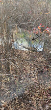
That is a shadow, Pan.
The shadow of what? I don't see anything there to cast that long shadow. Also, It looks like it was mid-day with the sun coming from high overhead. Also, I think there's more vegetation in the dark place than the light. I think it's a trench.
Last edited: