D
Deleted member 7363
Guest
Didn't see anything like this so I am starting a thread. Please merge with an existing thread for roads if it exists.
I have returned to NJ after nearly 20 years and a lot has changed. The off road issue wasn't something I remember in the late 1990s or early 2000s. Back then, I took my 1991 Buick and later my 2003 Civic on many roads and never had issues. I was never stuck, and typically just went around or through the mud holes without issue. The worst I ever had with getting stuck was the tracks at high crossing, which were removed in late 1998 or early 1999. Yesterday, while on a 22 mile botched hike involving the Penn Branch Trail and the Sandy Ridge-Tulpehocken "trail", I found many of the roads I encountered to be rutted and possibly impassible for my outback, at least they could be if I hit a rutted mud hole wrong.
I have concerns about the road quality and am hoping people might be able to update road conditions. At this time, I am seeking to travel from Atsion to Quaker Bridge, and beyond perhaps to either Mount or Washington, and either return via 563 through Chatsworth, or the Basto- Washington Road and 542. What is the road quality like? Are there a lot of mud holes with deep ruts, or is this road well maintained similar to what I walked while on the Tuckerton Rd?
I am most interested or concerned with the road between Atsion and the area just east of Quaker Bridge, as I would like to explore the burned area east of the Basto River, and south of access road. Also, for locals, does anyone know anything about the fire frequency of that area since the larger hot growing season fire that occurred around 2017? It looked like a second fire has occurred in that area since, perhaps in '22 or '23.
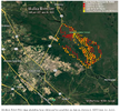
I attached a map with Quaker Bridge at upper left and Mount marked with a yellow weigh-point.
Thanks.
Jim
I have returned to NJ after nearly 20 years and a lot has changed. The off road issue wasn't something I remember in the late 1990s or early 2000s. Back then, I took my 1991 Buick and later my 2003 Civic on many roads and never had issues. I was never stuck, and typically just went around or through the mud holes without issue. The worst I ever had with getting stuck was the tracks at high crossing, which were removed in late 1998 or early 1999. Yesterday, while on a 22 mile botched hike involving the Penn Branch Trail and the Sandy Ridge-Tulpehocken "trail", I found many of the roads I encountered to be rutted and possibly impassible for my outback, at least they could be if I hit a rutted mud hole wrong.
I have concerns about the road quality and am hoping people might be able to update road conditions. At this time, I am seeking to travel from Atsion to Quaker Bridge, and beyond perhaps to either Mount or Washington, and either return via 563 through Chatsworth, or the Basto- Washington Road and 542. What is the road quality like? Are there a lot of mud holes with deep ruts, or is this road well maintained similar to what I walked while on the Tuckerton Rd?
I am most interested or concerned with the road between Atsion and the area just east of Quaker Bridge, as I would like to explore the burned area east of the Basto River, and south of access road. Also, for locals, does anyone know anything about the fire frequency of that area since the larger hot growing season fire that occurred around 2017? It looked like a second fire has occurred in that area since, perhaps in '22 or '23.
I attached a map with Quaker Bridge at upper left and Mount marked with a yellow weigh-point.
Thanks.
Jim
Attachments
Last edited by a moderator: