South Jersey Trailheads Map

All the South Jersey hikes I've documented so far (100+), in one convenient Google Map.

https://www.google.com/maps/d/viewer?hl=en_US&app=mp&mid=zHMMSPVsm8jY.k9IovO_5Sq0U

I'm sad, because I figured out how to add GPS tracks, but Google limits you to only 10 layers, and each GPS track has to be its own layer. :(

Still have 100 trails or so to do on my list (and I know my list is far from complete), this project is going to take way longer than I thought...
 

manumuskin

Piney
Jul 20, 2003
8,673
2,586
60
millville nj
www.youtube.com
if you click on the maurice river bluffs icon there is a little kid sitting at a picnice tabe.That it where me mom and dad used to camp and fish all the time back when this was all private property in the 70's.the picnice table is on the exact spot the tent used to sit
 
  • Like
Reactions: MikeBickerson

nipsey russell

New Member
Sep 15, 2014
25
7
Philly Burbs
this is awesome, thanks! I have been creating a similar map for myself over the years (focused around where i live, but with some pines additions: https://www.google.com/maps/d/edit?mid=zLcz6Hi5RESA.kqEIaVptJxvk&msa=0). Question, i hand drew batona on my map, do you know how can i get the actual accurate one ported to my map?
Word of caution, google occasionally updates the map stuff....seemingly to make it less useful over time.
 
  • Like
Reactions: MikeBickerson

manumuskin

Piney
Jul 20, 2003
8,673
2,586
60
millville nj
www.youtube.com
Okay this is pretty close to the exact route at least from the best my memory can tell.It used to be blazed white,I imagine it still is.I forget the name of the trail so I named the map Nummy Trail.east of east Creek Pond it is a very wet trail for a mile or so.Some times you'll be walking in water for hundreds of yards at a stretch and the laurel is so thick you pretty much have to stay in the trail.Lot of ticks too.Got filled with ticks every time I walked it in warm weather. Nice walk though.Savages Run is a very nice but narrow cedar swamp.
 

Attachments

  • Nummy Trail.jpg
    Nummy Trail.jpg
    176.3 KB · Views: 382
  • Like
Reactions: MikeBickerson

manumuskin

Piney
Jul 20, 2003
8,673
2,586
60
millville nj
www.youtube.com
Many of the red trails they show on this map are driveable dirt roads.The cinder trail is named that because it's a road surfaced with slag.
I had forgot about Pickle Pond Trail.They had just made that trail about the time I moved out of Belleplain.I walked it a few times,once to get to a really big stone which i believe is a Proprietor Stone. A few big stones on this map area. Pickle pond trail would probably make it ten or eleven miles if you extended it down there and walked back to Nummy.
 
  • Like
Reactions: MikeBickerson

Boyd

Administrator
Staff member
Site Administrator
Jul 31, 2004
9,827
3,009
Ben's Branch, Stephen Creek
Thanks Manumuskin! I haven't done many of the trails at Belleplain, I'll have to add the white trail to the to-do list...

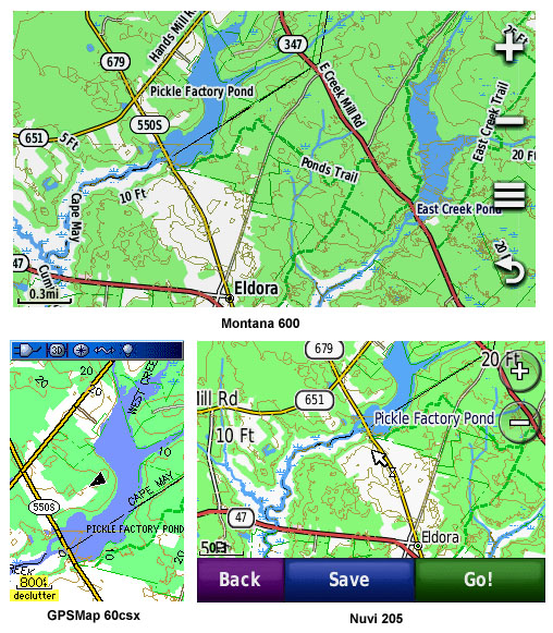
If you have a Garmin GPS, my 2012 NJ map has pretty much all of the Belleplain trails: http://www.gpsfiledepot.com/maps/view/294/

If you don't have a Garmin GPS, you can still use my map on your computer with Garmin's free Basecamp program. Some people still prefer their older Mapsource software which is also free: http://www8.garmin.com/support/mappingsw.jsp

screenshots.jpg
 
Okay this is pretty close to the exact route at least from the best my memory can tell.It used to be blazed white,I imagine it still is.I forget the name of the trail so I named the map Nummy Trail.east of east Creek Pond it is a very wet trail for a mile or so.Some times you'll be walking in water for hundreds of yards at a stretch and the laurel is so thick you pretty much have to stay in the trail.Lot of ticks too.Got filled with ticks every time I walked it in warm weather. Nice walk though.Savages Run is a very nice but narrow cedar swamp.

This one just totally made my list once the cold weather hits (kid had tick on him yesterday, so time to start avoiding heavy growth areas). The google map is really helpful, thanks!
 
  • Like
Reactions: manumuskin
If you have a Garmin GPS, my 2012 NJ map has pretty much all of the Belleplain trails: http://www.gpsfiledepot.com/maps/view/294/

If you don't have a Garmin GPS, you can still use my map on your computer with Garmin's free Basecamp program. Some people still prefer their older Mapsource software which is also free: http://www8.garmin.com/support/mappingsw.jsp

screenshots.jpg
Awesome! Thanks Boyd.

I do have a Garmin, but it's been gathering dust. This is a good excuse to get it out and try to remember how to load maps onto it.
 
  • Like
Reactions: manumuskin and Boyd
Top