Stargazers Pit

Espo55

Scout
Mar 24, 2011
33
0
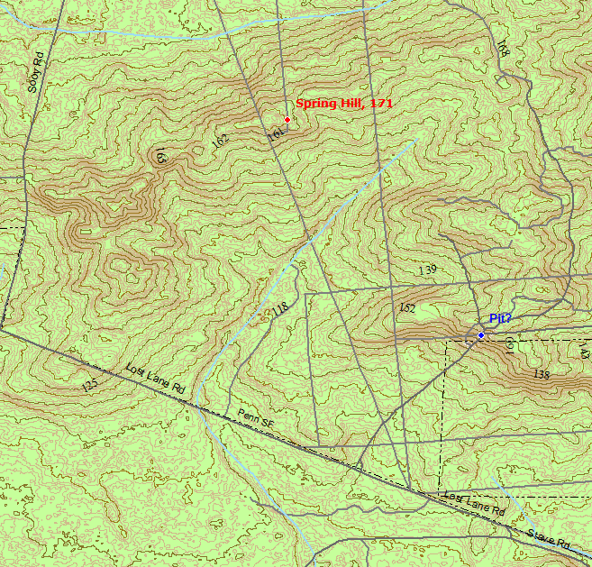
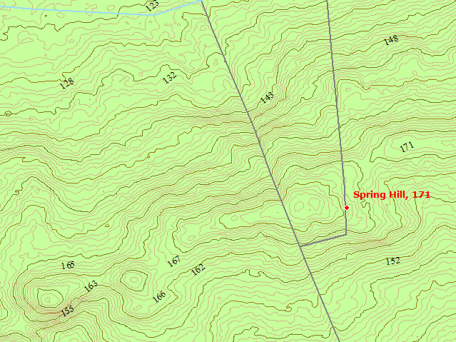
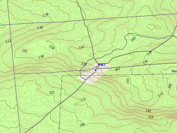
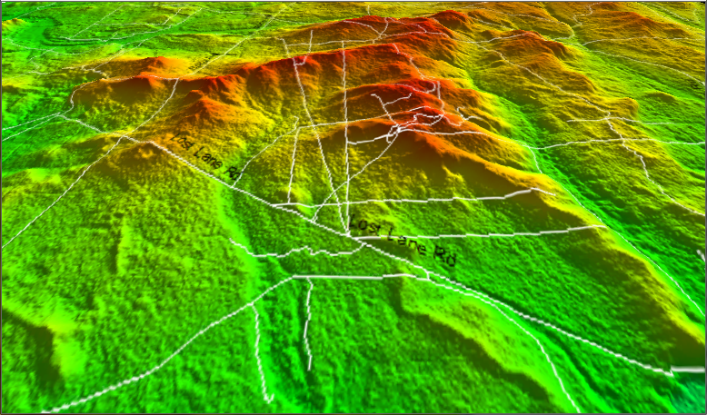
I was recently reading a forum on here, before I created my profile, about a place called "Old Halfway" or "Hidden Lakes." I found the forum extremely interesting, because I had just been out there for the first time with a couple of my friends, and had never been there before or heard much about it anywhere. At any rate, my surprise at that aside, I was wondering if any of you on here have ever heard of or been to a place that I've heard referred to as Stargazer's Pit; I know names vary, but its a sand arena in Penn State Forest on Spring Hill Road. The first time I was out there I thought that we were trespassing because I wasn't paying attention to the way we were driving and I got into thinking that we were between 70 and 72 and I believe much of that is private land. Anyway, it's south of 72, in Penn State Forest, so when I was out there a few days ago, I had a better gauge on my bearings. Just wondering if any of you have been there and have any info on it or stories about it, it really is one of the most beautiful places I've been in the pines. The view to the southwest is great.

Mike "Espo"
 

woodjin

Piney
Nov 8, 2004
4,341
327
Near Mt. Misery
It sounds like you were at spring hill, which is a very beautiful spot for vistas. I have never heard it referred to as stargazers pit, but it is a good spot for that. There is another pit in that area to the east, the red pit, but it is just a pit without the hill.

Jeff
 

Espo55

Scout
Mar 24, 2011
33
0
Thanks Jeff,

That makes perfect sense, considering its on Spring Hill Road, but I never heard it called that. Very interesting, I've never been to the pits that are to the east of it but I've seen them to the map. When you look to the south from Spring Hill there appears to be a cedar swamp in the distance, either a river or a low hill. Nonetheless very cool.
 

manumuskin

Piney
Jul 20, 2003
8,554
2,466
59
millville nj
www.youtube.com
the pit just east of sooy road on the south flank of spring hill on both side of the road i have heard referred to as satellitel pit and telescope pit because an enduro friend of mine was riding through there on his bike near dusk and found two guys setting up a scope.it is a staging area for his group when they go out just to ride.they park there.
 

Espo55

Scout
Mar 24, 2011
33
0
the pit just east of sooy road on the south flank of spring hill on both side of the road i have heard referred to as satellitel pit and telescope pit because an enduro friend of mine was riding through there on his bike near dusk and found two guys setting up a scope.it is a staging area for his group when they go out just to ride.they park there.

I'll check that pit next time I'm out there, I have to go with one of my friends that has an offroad-capable vehicle because I drive a Crown Vic that gets stuck in everything haha...or I can hike there...either way that won't be for a least a few weeks but I'll check it.
 

Boyd

Administrator
Staff member
Site Administrator
Jul 31, 2004
9,536
2,792
Ben's Branch, Stephen Creek
What's in a name?

Spring Hill is one of my favorite places, and I was just playing around with the LIDAR DEM imagery of the area. The following shows some of its complexity using 1 foot contour intervals.

springhill01.png


But the guvermint thinks Spring Hill is someplace different than most of us do... the red dot is location in the GNIS (http://en.wikipedia.org/wiki/Geographic_Names_Information_System)

springhill03.png


But we this is the "pit" that I think is being referred to.

springhill02.png


Here's the whole "mountain range".

springhill04.png


Last summer I wanted to check out the "real" Spring Hill, and it is in woods on a pretty overgrown trail, with no view. :)
 

woodjin

Piney
Nov 8, 2004
4,341
327
Near Mt. Misery
the pit just east of sooy road on the south flank of spring hill on both side of the road i have heard referred to as satellitel pit and telescope pit because an enduro friend of mine was riding through there on his bike near dusk and found two guys setting up a scope.it is a staging area for his group when they go out just to ride.they park there.

oh yeah, the pit coming off of sooy going towards spring hill. Yeah, I wouldn't have thought that that would be as good for stargazing as spring hill. there used to be alot more jumps and things in that pit but then then they flattened it with a bulldozer a few years back. The north end still has some trails around it.

Jeff
 

Espo55

Scout
Mar 24, 2011
33
0
Boyd,

Where did you find that/those maps???

Yea, you're correct that the spring hill I referenced is the pit displayed on the third image you posted.

And my car certainly does make for some fun (no...) when it snows or I try to drive on anything that isn't nice clean paved road haha. I love that crown vic though.
 

ZZ3GMC

Scout
Sep 19, 2003
88
1
Pemberton
Visit site
Stargazers pit or telescope pit is private property. Owned by Haines. There has been quite abit of vandalism there by partiers lately. They cut down trees and burned them in a camp fire. Left their trash and have camped there overnight w/o the landowners permission. They have also carved all sorts of faces and stuff on the trees around the perimeter. I caught some kids camping there last week and let them know that they shouldnt be there. It is patrolled by the landowners foreman. I wouldnt suggest going there right now due to the vandalism.
 

Boyd

Administrator
Staff member
Site Administrator
Jul 31, 2004
9,536
2,792
Ben's Branch, Stephen Creek
Boyd,

That 3D map is something else. Is that online?

Thanks, but it is not available in this form online anywhere. I generated it using data that is available online however. See --> http://forums.njpinebarrens.com/general-discussion/8149-lidar-pines-very-cool.html

The topo maps were created using the LIDAR data combined with my map of New Jersey. That map is available here, but with lower resolution contours: http://www.gpsfiledepot.com/maps/view/294/

I am trying to decide what to do with this new data. I'm afraid that it will choke a Garmin GPS due to the high density of contour lines. But I'll be posting an update to my map of New Jersey sometime this summer that utilizes the LIDAR data in some form or other. :)
 

Espo55

Scout
Mar 24, 2011
33
0
Stargazers pit or telescope pit is private property. Owned by Haines. There has been quite abit of vandalism there by partiers lately. They cut down trees and burned them in a camp fire. Left their trash and have camped there overnight w/o the landowners permission. They have also carved all sorts of faces and stuff on the trees around the perimeter. I caught some kids camping there last week and let them know that they shouldnt be there. It is patrolled by the landowners foreman. I wouldnt suggest going there right now due to the vandalism.


I thought we were considering that Stargazer's pit was known as Spring Hill and that the "red pit" was also called telescope pit?
 

Broke Jeep Joe

Explorer
Mar 8, 2006
779
475
Waterford Twp
Stargazers pit or telescope pit is private property. Owned by Haines. There has been quite abit of vandalism there by partiers lately. They cut down trees and burned them in a camp fire. Left their trash and have camped there overnight w/o the landowners permission. They have also carved all sorts of faces and stuff on the trees around the perimeter. I caught some kids camping there last week and let them know that they shouldnt be there. It is patrolled by the landowners foreman. I wouldnt suggest going there right now due to the vandalism.

ZZ3, are you sure the pit on Spring Hill Road is private? On the map it looks as if it is in a small corner of Penn? The second pit to the east on or near Long Casueway Rd (red pit) Jeff reffered to looks like it is on private property. Just want to make sure I'm not going someplace I shouldn't be
 

manumuskin

Piney
Jul 20, 2003
8,554
2,466
59
millville nj
www.youtube.com
Stargazers pit or telescope pit is private property. Owned by Haines. There has been quite abit of vandalism there by partiers lately. They cut down trees and burned them in a camp fire. Left their trash and have camped there overnight w/o the landowners permission. They have also carved all sorts of faces and stuff on the trees around the perimeter. I caught some kids camping there last week and let them know that they shouldnt be there. It is patrolled by the landowners foreman. I wouldnt suggest going there right now due to the vandalism.

ZZ3, are you sure the pit on Spring Hill Road is private? On the map it looks as if it is in a small corner of Penn? The second pit to the east on or near Long Casueway Rd (red pit) Jeff reffered to looks like it is on private property. Just want to make sure I'm not going someplace I shouldn't be

The half of the pit north of the road is Haines property,the southern half across the road is on Penn State Forest.Haines property is bordered by a mowed cut with signs on either side of the pit.
 

Espo55

Scout
Mar 24, 2011
33
0
So the Red Pit is on private property and part of Spring Hill is in Penn State Forest? It is pretty difficult to tell from maps but it looks like Spring Hill is at least partially in Penn.
 

Broke Jeep Joe

Explorer
Mar 8, 2006
779
475
Waterford Twp
So the Red Pit is on private property and part of Spring Hill is in Penn State Forest? It is pretty difficult to tell from maps but it looks like Spring Hill is at least partially in Penn.

Thats what I thought too.

Al,

So about 1/2 of the pit is Penn and 1/2 is Haines? So you legally can't drive through it without permission?
 

Espo55

Scout
Mar 24, 2011
33
0
Well, if you're driving on a named road you're following "traffic regulations" even though they're never posted, you should be able to pass through anything that isn't a private drive. Spring Hill Road isn't a private drive or access, so you should be able to use it as you would be using any other road, though you might not be allowed to go through the forest thereabouts.
 

Boyd

Administrator
Staff member
Site Administrator
Jul 31, 2004
9,536
2,792
Ben's Branch, Stephen Creek
You can see the Penn State forest border in the map I posted on the previous page. It's the dashed line that goes through the middle of the pit. When I get home tonight, I can post a better image that shows the State Forest borders in that area.

I believe they are also included on the Google Earth open space file that I posted in a thread about WMA maps awhile ago.
 

Broke Jeep Joe

Explorer
Mar 8, 2006
779
475
Waterford Twp
You can see the Penn State forest border in the map I posted on the previous page. It's the dashed line that goes through the middle of the pit. When I get home tonight, I can post a better image that shows the State Forest borders in that area.

I believe they are also included on the Google Earth open space file that I posted in a thread about WMA maps awhile ago.

Thanks Boyd, very clear now!
 
Top