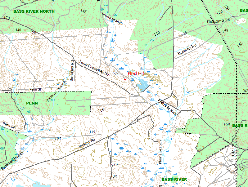
just so there is no confusion, this is the red pit
http://maps.njpinebarrens.com/#lat=39.7696816316501&lng=-74.41535711288452&z=17&type=h&gpx=
http://maps.njpinebarrens.com/#lat=39.7696816316501&lng=-74.41535711288452&z=17&type=h&gpx=

just so there is no confusion, this is the red pit
http://maps.njpinebarrens.com/#lat=39.7696816316501&lng=-74.41535711288452&z=17&type=h&gpx=
So I would guess going with Boyd's map guideline, the Red Pit is on Haines property, or at least it is not in Penn right?
the red pit has always been posted. I believe it is Haines or now NJCF.
we always called it the red pit because it is filled with red sand like on nearby red road (stephens road)
If the red pit is with njcf, does that mean its now public land?
NJCF is public access, usually NMV though
Ha... now I realize I have been to that place. It is just down the road from the Nature Conservancy property where they tore down the cabin on the lake (we used to call it "TNC House" here a few years ago). It has been several years since I went there, and there was a lot of trash laying around. It was definitely posted. I don't think Penn State Forest goes that far.
As I said, I will post a map that shows which areas are public space in that vicinity when I am home later this evening.


")
Abstract:
This data set contains protected open space and recreation areas owned in fee simple interest by the State of New Jersey Department of Environmental Protection (NJDEP). Types of property in this data layer include parcels such as parks, forests, historic sites, natural areas and wildlife management areas. The data was derived from a variety of source maps including tax maps, surveys and even hand-drafted boundary lines on USGS topographic maps. These source materials vary in scale and level of accuracy. Due to the varied mapped sources and methods of data capture, this data set is limited in its ability to portray all open space lands accurately, particularly the parcels purchased prior to 1991.
Current Mapping Methodologies:
Since 1995, the bulk of open space acquisitions are entered into the GIS using a certified survey of the properties boundaries; ArcInfo facilitates the incorporation of surveys. Much effort is made to enter data within a year of the purchase. Tax map lines are utilized only if a survey does not exist or if internal lot lines were not drawn in the survey.
Survey lines: When surveys are available, CAD files of the parcel are entered into the ARCINFO polygon coverage version of NEWSTATE. Nad83 or Nad27 NJSPC certified surveys are the best available sources with regard to shape and positional accuracy. Non-NJSPC certified surveys provide the best parcel shape but not position. They are repositioned to fit the features present on the on-screen image (2002 imagery). If interior lot lines are omitted on either type of survey, then tax map lot lines are added using the "best fit" method mentioned above.
Tax map lines: The appropriate pages from a current tax book are scanned, saved as tiff files and brought into the GIS and rectified using an ARCINFO/ArcMap program and 2002 digital imagery. Only the property lines that compose the acquisition are digitized on screen and added to the coverage.
http://www.state.nj.us/dep/parksandforests/parks/docs/penn_sf_history.pdf
while looking for online maps to clarify the boundaries which I then seen Boyd had already done.I happened upon this history of the area.A good read.
Notice they gave my article credit
Guy
