I"ve been to that broken stone but don't recall it being broken.That had to be at least ten years ago nowSpent some time this morning planning our searching and will be visiting an area again where I found this stone broken and repaired in 2011. It actually is the Parker Preserve but not an area where much goes on.
View attachment 20837
Stone Searching Fall/Winter 2023-2024
- Thread starter Teegate
- Start date
You are using an out of date browser. It may not display this or other websites correctly.
You should upgrade or use an alternative browser.
You should upgrade or use an alternative browser.
We spent the morning walking almost 4 miles on the eastern side of the Tub Mill Branch after crossing over from the western side. It really is just a wet cedar swamp with not much water flow. Our goal was to look for some of the monuments from the mysterious state forest that somehow is not one and never was. The monuments have been there since at least 1956 but the state has only acquired some of the property as recently as the 1980s. Some of the property is still private. It just is impossible to understand how that can be. And this is not the only one that is mysterious.

Anyway, I found one quite a few years back and today we found another one. It is out of the ground and may be as far as 75 feet from where it should be.

NJ306

While looking for others we found a solar panel in a tree with a large battery burned up on the ground. It looks like it was hooked to what was a game camera. There was a broken bracket in the tree with smaller regular batteries on the ground. I have to think the big battery was charging the rechargeable batteries in the camera.


I flushed this out on purpose because the photos seemed really dark when I took them.

And we crossed a nose bleed hill

Anyway, I found one quite a few years back and today we found another one. It is out of the ground and may be as far as 75 feet from where it should be.
NJ306
While looking for others we found a solar panel in a tree with a large battery burned up on the ground. It looks like it was hooked to what was a game camera. There was a broken bracket in the tree with smaller regular batteries on the ground. I have to think the big battery was charging the rechargeable batteries in the camera.
I flushed this out on purpose because the photos seemed really dark when I took them.
And we crossed a nose bleed hill
Very cool photos! It's incredible the amount of documentation and info you and Jessica are able to provide on these places. Some historian's going to be very glad you did all this one day. Looks like you're having fun.
What brand of muck boots is she wearing? They look nice and sturdy for exploring.
What brand of muck boots is she wearing? They look nice and sturdy for exploring.
This is the link to the pair she has. She just bought a new pair a month ago when it was on sale for $69. Look at the price now. She didn't need a new pair but bought them anyway and stored them away for the future.
I get a text message last night from someone I know and they informed me they found a monument in Lebanon near an intersection of a couple dirt bikes paths. They had found one a while back in a slightly different area and I have not been able to figure out what it was for. So today we headed out to look for the monument they found recently. We started walking around and in a short while Jessica yelled that she had discover it, but when I got there it was not the same one. This one was taller and not chipped all around the top and the trees in the photo I was sent did not match up.

Realizing there was at least two in the area we spent almost an hour walking around in circles looking. Eventually, I came to a location where motorcycle trails intersected and there was the original monument we were looking for.

The block and lot that the monuments are on was 2437.33 acres and these monuments were not any of the corners of that tract. The 2437.33 lot is one of the first properties acquired by the state for Lebanon Forest on 2/29/1908. This tells me that the monuments above, if they are property corners, predate 1908. And there have to be more of them which we will be looking for in the near future. The lot most likely was gobbled up by Durant and became part of the large tract he sold to the state. The monuments are most likely long lost property corners to a much smaller tract.

Changing locations, we walked behind the 2 water wells across from Butler Place to check out the pit there that most likely helped build Route 72. I noticed it on Lidar and wanted to check it out. It does not show up in the 1931 aerials but does in the 1940 aerial. By 1956 it is almost completely hidden from view.

And then to the Gates branch to look for a sawmill that Beck visited. He had no idea at the time what it was.
The Gates Branch cedar swamp.

Realizing there was at least two in the area we spent almost an hour walking around in circles looking. Eventually, I came to a location where motorcycle trails intersected and there was the original monument we were looking for.
The block and lot that the monuments are on was 2437.33 acres and these monuments were not any of the corners of that tract. The 2437.33 lot is one of the first properties acquired by the state for Lebanon Forest on 2/29/1908. This tells me that the monuments above, if they are property corners, predate 1908. And there have to be more of them which we will be looking for in the near future. The lot most likely was gobbled up by Durant and became part of the large tract he sold to the state. The monuments are most likely long lost property corners to a much smaller tract.
Changing locations, we walked behind the 2 water wells across from Butler Place to check out the pit there that most likely helped build Route 72. I noticed it on Lidar and wanted to check it out. It does not show up in the 1931 aerials but does in the 1940 aerial. By 1956 it is almost completely hidden from view.
And then to the Gates branch to look for a sawmill that Beck visited. He had no idea at the time what it was.
The Gates Branch cedar swamp.
Last edited:
I found this article mentioning William L. Durant who sold the first property to the state for Lebanon State Forest. I mention him in the above post. There is other historical info mentioned as well. BTW, for the first time I dictated this and will be doing that from now on. Saves me from typing.
3/12/1933
According to records recently brought to light by the New Jersey department of conservation and development in 1851 a Thomas and Samuel Richards, directed a large glass factory here and named the place Lebanon. They also built 60 dwellings and the sawmill in connection with the glassworks due to the superior quality of the clear window glass they manufactured.
The project was a marked success from the beginning and busy times they employed 150 men. The business was carried on until about 1866 when sufficient supply of timber necessary to operate the glassworks became nearly exhausted, and the factory was abandoned. In 1881 the property was purchased by Chetwood Giles, and company of New York City. They lease the sawmill to Samuel Lee, who operated it until 1883.
When Lebanon State Forest was establish in 1908 the state of New Jersey purchase from William L Durant and his wife, 2473 acres of land known as the Lebanon tract, including the site of the village of Lebanon. At this time it was an abandoned village, mostly ruins, except one or two dilapidated houses that were still standing. With the development of the forest these buildings were cleared away, and plantations of seedlings set out to reclaim the land.
The site of the old glass factory may still be easily located by the bits of glass and slag strewn about on the ground. One small shanty, moved there by Victor Bush after he became a warden on the Lebanon State Forest now stands where the main business corner of this almost forgotten manufacturing community was located years ago. Lebanon Glasshouse, the name by which the spot is still locally known as recent as 1932 had one inhabit name Voughding. He was a glassblower when he was a young man, and had been employed by many glass factories in South Jersey. Mr. Voughding spent the last few years of his life very happily in the little shanty, where the busy little industrial community of Lebanon once stood.
Jessica has covid so I was again on my own today. I decided to go back to the possible fake State Forest in Bass River to look for some of the monuments I did not look for the other times we were there. A little after 7AM I arrived and again walked down Tub Mill Road and crossed the Tub Mill Branch. For the next 3 hours I walked traveling over 5 miles when I finally arrive back at my car. I took video of my crossing which I will post later. After crossing I had two monuments to look for in one direction so I took that route to start out. Fairly quickly I was able to find them. One of them was 100 feet away from where I thought it would be.
The fire was the greatest event to happy out there. It is so nice walking around.

All of the monuments I found today.. I will continue working on trying to figure out what the deal is with this piece of property.


I also was looking on Lidar and noticed another location where they could be a stone hill and when I arrived that is just what it was even though this one was a very small hill.

When my exploring was over I was quite a ways away from even crossing back over the Tub Mill so I made a straight line walk heading back. I then joined the route Jessica and I used last week and followed that for a while. I was walking the exact same route shown on my GPS when something caught my eye in the trees. I don't know how we missed this last week.
This is about a 1940 Paddy Wagon I would say. Let's discuss this and come up with a conclusion. I think it may have been altered for camping.


The door even opens easily.


This was the piece sticking out the back. It may be a stove exhaust?? It says
G
U
I
D
E
-
R
17
T

The car is on railroad ties and either was stolen or maybe a hunter used it for hunting and just propped it up on them.
Here is a video as I walked around it.
Click Here To View Car Video
The fire was the greatest event to happy out there. It is so nice walking around.
All of the monuments I found today.. I will continue working on trying to figure out what the deal is with this piece of property.
I also was looking on Lidar and noticed another location where they could be a stone hill and when I arrived that is just what it was even though this one was a very small hill.
When my exploring was over I was quite a ways away from even crossing back over the Tub Mill so I made a straight line walk heading back. I then joined the route Jessica and I used last week and followed that for a while. I was walking the exact same route shown on my GPS when something caught my eye in the trees. I don't know how we missed this last week.
This is about a 1940 Paddy Wagon I would say. Let's discuss this and come up with a conclusion. I think it may have been altered for camping.
The door even opens easily.
This was the piece sticking out the back. It may be a stove exhaust?? It says
G
U
I
D
E
-
R
17
T
The car is on railroad ties and either was stolen or maybe a hunter used it for hunting and just propped it up on them.
Here is a video as I walked around it.
Click Here To View Car Video
Last edited:
So it looks like the GUIDE R17T is a tail light.

 www.jalopyjournal.com
Guide R 17 T tail light???????
I found a Guide R17T tail light last week, in a junkyard here. It has the same license lens as my Sportster, and the missing red lens looks like a...
Nice find Guy!
I noticed, as I'm looking at it, those window ovals look like they were cut into the vehicle later. They look a little uneven.
I noticed, as I'm looking at it, those window ovals look like they were cut into the vehicle later. They look a little uneven.
Last edited:
Nice find Guy!
I noticed, as I'm looking at it, those window ovals look like they were cut into the vehicle later. They look a little unever.
Could be. It looks like quite a bit was cut. The roof had some sort of vent pipe.
Jess and I will go back soon. We have other things to find and will go again to the vehicle. There is a massive amount of open land right near there that most likely has not been explored since the fire. We could find more things.
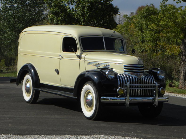
This older one is much closer. A 41.
Easy, I just searched wide open in Google set to images: "old panel trucks".Nice find Guy.
Bob, how did you find the great pictorials of the 1941 Chevy van?
That truck you found is quite special Guy. If that had been restored, it would be a beautiful example of early Americana, even if modified.
Maybe some searches with the surrounding towns in the name might bring something up; like "new paddy wagon in Tuckerton" or some such.
Another thought; maybe it's an old convict truck for transportation to clean the roads or work in the blueberry fields.
Maybe some searches with the surrounding towns in the name might bring something up; like "new paddy wagon in Tuckerton" or some such.
Another thought; maybe it's an old convict truck for transportation to clean the roads or work in the blueberry fields.