Stone Searching

Teegate

Administrator
Site Administrator
Sep 17, 2002
25,627
8,228
I'm glad to here that Jess is feeling better. That first photo of the cellar hole with the garbage in it....I think I know where that is. Is it on the north side of 532, west of the lake? Kind of near the blue water sand pit?

Jeff

It is close to Dukes Bridge.

Guy
 

Teegate

Administrator
Site Administrator
Sep 17, 2002
25,627
8,228
I have not been feeling well and did not want to pass on a day in the pines, so Jessica and I headed to the Parker Preserve to check on a location that Al was at this week. He ran into a man in the woods who showed him around somewhat, and this is the result. A triangle monument and stone.


IMG_7175.JPG


IMG_7176.JPG


From there we headed to Bass River to roam around an old bog that is now part of the Parker Preserve and the state has a 40% interest in it. I had given Al the info last week and he has become quite good at calculating locations and his work and the result was pretty impressive. Now we have to figure out who it is.


IMG_7179.JPG


I am assuming the 7 means there are at least 6 more of them. We have some work to do :)


A smaller one in the area. We found a few more but I will pass on the photo's.

IMG_7191.JPG


Then we travleed over to Bards Bridge Road where the state also acquired some property back in 2008. It had about 50 feet of road frontage so we legally could walk the complete property without worries. It really is impressive how many little and mid sized pieces of property that the state owns all around that very few people even know about. This one was quite nice in the far back of it.

The first stone laying on the ground.

IMG_7199.JPG


Towards the back.

IMG_7200.JPG


In a swamp.

IMG_7201.JPG


The monument along the road. The second photo shows it again and one is next to my car. That is all the access from the road this property has.


IMG_7203.JPG


IMG_7196.JPG


And this tree seems to be a tree inside of a tree.


IMG_7208.JPG


Guy
 

Teegate

Administrator
Site Administrator
Sep 17, 2002
25,627
8,228
Something tells me that the same person incised both stones. They are not far from each other. I wonder if there was a date on that stone and it has chipped or worn off?

stone.jpg


Guy
 

manumuskin

Piney
Jul 20, 2003
8,554
2,466
59
millville nj
www.youtube.com
That is a neat tree Guy,was that the heartwood exposed by lightning or was it really some knid of tree growing around an older one?
Yes those letters are similar and could be the work of one lapidarist. Do they do that by hand with a chisel or is that some kind of stamp they can clamp the stone in and do it with heat/pressure?That is awfully neat for a chisel and i don't think they had modern day electric chisels.
I wasn't sure if that was a 7 or a J since I did not yank the stone completely out like you did for fear of not being able to get it back in the hole but now it is obviously a 7 and we have six more to find.First i think we need to know who WS is,that would be a big help.Surveyor or property owner?
Al
PS
I think your right about the triangular stone,it is most likely concrete.I have seen stones cut in that fashion but never a concrete shaped as anything but square.
Al
PPS
you can see where the line of the ground was.all I seen was that one leg of the W and was not sure if it was carved or a natural groove.I dug into the humus with my fingers and could trace the W with my fingers and thought this baby has got to come out so I kept digging till my fingers wrapped around the bottom and I thought heck if thats all the bigger it is i can shake it loose which i did and got a much better look but it was heavy and was concerned it wouldn't go back in right so i didn't roll it out.you got a much better p[hoto by yanking it all the way out.
 

Teegate

Administrator
Site Administrator
Sep 17, 2002
25,627
8,228
All,

Jessica and I spent the morning wandering though a fairly recent addition to Wharton in Medford and Evesham. The Girl Scouts sold one half of their property to the state and it is now part of Wharton. It is an excellent addition!

We started our day along the power lines.


IMG_7222.JPG


Someone in the past used old marble monuments from a cemetery to mark the property.


IMG_7224.JPG


An old stone marked by two pipes.

IMG_7225.JPG


Had to dig for this one.


IMG_7226.JPG


IMG_7227.JPG


This is the first stone I have found on the Evesham line. This one meets Medford.


IMG_7228.JPG


IMG_7232.JPG


Sitting on one.


IMG_7233.JPG


IMG_7234.JPG


Me!

IMG_7236.JPG


IMG_7237.JPG


Camp


IMG_7238.JPG


IMG_7239.JPG


IMG_7240.JPG


Taking a break. She has a cold and was having trouble breathing.


IMG_7246.JPG


IMG_7250.JPG


IMG_7252.JPG


IMG_7253.JPG


I guess a hunter. He has all the comforts he normally would have in his living room.


IMG_7255.JPG


IMG_7256.JPG


IMG_7257.JPG


IMG_7259.JPG


IMG_7261.JPG


IMG_7263.JPG


Did you loose your keys???


IMG_7264.JPG


IMG_7266.JPG


IMG_7268.JPG


Guy
 

turtle

Explorer
Feb 4, 2009
653
213
a village...in the pines
Man you guys were busy today. Any idea why the markers are made of marble? Seems to be alot of them. The Girl Scout camp sure has changed since I was there in 71-75' The tents were much nicer back then :D. Did you walk the whole property boundary? Beautiful day to be out. Glad you and Jess were enjoying it.

turtle
 

Teegate

Administrator
Site Administrator
Sep 17, 2002
25,627
8,228
Man you guys were busy today. Any idea why the markers are made of marble? Seems to be alot of them. The Girl Scout camp sure has changed since I was there in 71-75' The tents were much nicer back then :D. Did you walk the whole property boundary? Beautiful day to be out. Glad you and Jess were enjoying it.

turtle

Yes we did walk the complete boundary but that is something one should NEVER do. Even though the state purchased the complete property, they only purchased the "conservation easement" for the section where the buildings are located. Only the wooded "unused" portion of the tract is usable by the public and part of Wharton. Because I was not completely clear on this I made sure I had Jessica with me today and unfortunately we were approached and questioned. It turns out a "conservation easement" allows the owners of the property to retain ownership while protecting the property from further development of any kind which is spelled out in writing and agreed upon. The state has the right to inspect the property to make sure the agreement is kept, but other than that the state and public have to stay clear. I believe as I always do that because I had Jessica with me, and because I was "almost" completely informed about the property, we had no problems with our encounter today. And because the person we encountered was extremely nice and courteous, Jessica and I can sleep tonight in our respective beds and not in a jail cell.

I would recommend anyone who goes there to be well informed of where they are.


Guy
 

Teegate

Administrator
Site Administrator
Sep 17, 2002
25,627
8,228
The one I posted is along the power lines and you can go there. I also gave you a location where we now know you can't go, but I have determined the stone is on the golf course property on the other side of Kettle Run. It is right on the edge of the green.

Guy
 

manumuskin

Piney
Jul 20, 2003
8,554
2,466
59
millville nj
www.youtube.com
we need some of these stones here in the barrens.plant a ring of them around apple pie hill,forkerd river mountain and some of the high areas up along 539.Thats about the only tsunami safe areas in south jersey:)
Al
 

Teegate

Administrator
Site Administrator
Sep 17, 2002
25,627
8,228
All,

It has been a while since Al and I have stone hunted together, so today we decided to try our luck in Bass River Township where we will most likely be spending quite a bit of time in until the weather warms up. Like the WP 1700 stone, many of the stones we found today date back to that era.

Our first stop was where I had found a stone last week. Doing a little bit of research I found out that this stone was a property corner that should have the initials T & P on it. It only stuck up two inches and I suspected the letters would have been broken off; however, after Al and I dug around it the letter P became evident. I suspect the T was above it and is now forever gone. And again we learned the dangers of digging around them as Al found pieces of glass as we dug. One day we will get a serious cut digging around a stone.

The letter P.

IMG_8799.JPG


After there we found multiple monuments and one with a stone.

IMG_8808.JPG


Next, we headed towards our goal to find at least one more inscribed stone. Al had been in this area years ago but had not found it. Today, we were much luckier. This stone is the beginning corner to a 25 acre property for a Joseph Burns, and also the beginning corner to an 85 acre property owned by a Thomas Reynolds. The R in Reynolds is obstructed but you can see all of the other characters.

The JB & TR stone.

IMG_8812.JPG


The letter T.

IMG_8819.JPG


We then changed locations and decided to look for a very old stone. I had spent over two hours here on my computer trying to figure out where this was. By using HistoricAerials, information I had acquired, and various other means, I came up with what I felt was the exact location. We had to plow through some interesting obstacles and some pretty dense woods to get there, and in the end we were less than 20 feet from it. This was a very rewarding find. The stone is from 1740 and is the beginning stone of 109 acres that was owned by one Jonathan Wright. Bass River township has some very old stones.


The JW2 (Jonathan Wright) stone. There are more to find.

IMG_8826.JPG


IMG_8831.JPG


There was one other inscribe stone we looked for but I have come to the conclusion it is no longer in existence. In any event, I may give it one more try.

Guy
 

Teegate

Administrator
Site Administrator
Sep 17, 2002
25,627
8,228
There were a few bright spots today. On my way down Jones Mill Road aka Old Tuckerton Road aka Chatsworth Road, I noticed there was what appears to be a semi recent control burn. Out in the woods down a hill in a bottle filled pit I saw this.

IMG_9298.JPG


These look like tower foundations and they have the same size metal sticking out of them as the foundation I visited recently in the Aserdaten area. Maybe an old communication tower foundation?

IMG_9300.JPG


At least one was connected to the other.

IMG_9301.JPG


Some sort of crane had to have put them at the location they are at.


Next, we headed to the Goose Pond area.

http://maps.njpinebarrens.com/#lat=39.78116793748862&lng=-74.48284149169922&z=14&type=m&gpx=

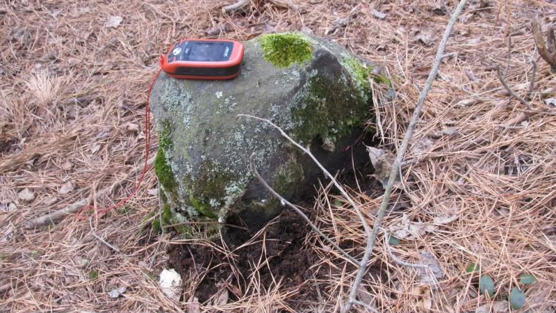
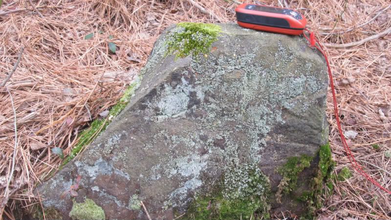
Much of this property, and I believe the complete pond is owned by Haines. The green area on the above map is Bass River North aka The Spring Hill Tract. Al and I now have the survey for the Spring Hill Tract and I went today looking for the Sykes Stone. The Sykes branch passes through that area and Anthony Sykes most likely is where the name came from. I had good info that the Sykes stone had an "S" incised on it and I wanted to see it. Jessica and I was able to drive pretty close to it and decided to walk the rest of the way. Towards the end the briers were pretty tough and Jessica tonight looks like Harry Potter on her head :) Her legs are just as bad. Anyway, when we got to the stone we found two of them, or so we thought. I am thinking now it was one large one and the second one had broken off from it. Unfortunately, we did not find an "S". I will go back again and dig around it.

The Sykes Stone.


IMG_9306.JPG


They thought they had the place to themselves......and then we arrived. They left.

IMG_9304.JPG


One of the Haines property corners hidden underground. An easy find :)

IMG_9303.JPG


And finally, at the end of our day we headed over to the Cedar Bridge Tavern area and headed into the woods to find a stone. This area was owned by Rudy Koenig until around 1976 when he sold the property to the NJ Conservation Foundation. Back then they had purchased quite a few tracts of land anticipating that the state would come up with the money eventually to buy it from them. And as anticipated the state acquired the 209 acres in 1980 for $84,500, the same price the NJ Conservation Foundation paid for it 4 years earlier. Rudy kept his house and the small property around it, and recently the county purchased that with Rudy having life time rights. Unfortunately, Rudy passed away last month.

The stone on the far eastern edge of his property.

IMG_9321.JPG


Rudy's obit for those who did not know he died.

http://ochistory.org/Rudy_Koenig_Obituary.php

Guy
 

Teegate

Administrator
Site Administrator
Sep 17, 2002
25,627
8,228
All,

Manumuskin and I spent the day searching for an untold amount of stones and were quite tired when the day was over. Most of them were interesting but one stood out above the rest. This is another WS (William Smith) stone, and this time there is a date on it. Unfortunately, this particular stone is on a survey line and many years back the surveyors put the large concrete monument directly in front of it. Didn't they know Al and I would be along soon looking to photograph it :)

So you tell me what the date is? I will have to return and clean it up a little to try and get this mystery solved.


IMG_9337.JPG


It appears to be 1760 something.

IMG_9340.JPG


And to further deepen the mystery there is an inscription on the back. It feels like and "I" when I ran my fingers in it so I would say it is "IA." The date looks like it is wearing away.

IMG_9343.JPG


Another view of the front date.

IMG_93390000.JPG


There was another interesting find by the two of us, and Al informed me he had one after I left. More on those at a later date.

Guy
 
Top