Symbols painted on the roads

Rubibee

Scout
Dec 10, 2002
50
0
Moorestown, NJ
Hello,

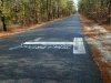
Many many times travelling down the pines we have seen something painted on the right side of 3 roads. They appear to look like "T"'s painted at different locations. Well yesterday we took gps readings on them and put them on the map - they appear in a triangle shape. There is also a forth one we have seen but this one is painted the opposite way that the 3 are.

If anyone has heard about what these "T" 's are or what they are marking could you let me know. We are very curious.

These are all located in Burlington County on well traveled roads.

I wasn't sure if it would be ok to post the cooridinates on here so if you need them you can email me.

Thanks in advance for your help.


--Bev
 

Teegate

Administrator
Site Administrator
Sep 17, 2002
25,656
8,266
A few years back I noticed the letter "X" painted on street all over the place, and read something online about aerial use of them. I can't remember exactly what it was which does not help much. Maybe it has something to do with that. I will search around and see if I can find the article I saw. Actually, I believe this subject came up once before and we never figured it out.

Guy
 
4WheelingBee sent me the coords in a PM. I do not know what they are for. Anyone?

1.) 39 50.066N I believe Chatsworth Rd (?)
74 38.123W

2.) 39 47.557N I believe Baptist Rd (?)
74 31.356W

3.) 39 46.772N Pretty sure Carranza Rd
74 38.313W

*4.) 39 48.262N Carranza Rd (?) near youth rehab
74 40.785W

* this is the one painted the opposite way
 

Teegate

Administrator
Site Administrator
Sep 17, 2002
25,656
8,266
BEHR655 said:
4WheelingBee sent me the coords in a PM. I do not know what they are for. Anyone?

1.) 39 50.066N I believe Chatsworth Rd (?)
74 38.123W

2.) 39 47.557N I believe Baptist Rd (?)
74 31.356W

3.) 39 46.772N Pretty sure Carranza Rd
74 38.313W

*4.) 39 48.262N Carranza Rd (?) near youth rehab
74 40.785W

* this is the one painted the opposite way

The second one is right near Harrisville.

Edit: Near Dukes Bridge. Sorry


Guy
 

Teegate

Administrator
Site Administrator
Sep 17, 2002
25,656
8,266
I have a post started on a site that surveyors frequent, so hopefully I will receive a response soon. Certainly Monday morning.

Guy
 

Teegate

Administrator
Site Administrator
Sep 17, 2002
25,656
8,266
So far I have three responses. Here they are in the order I received them. I will pass along any others I receive.

Guy

******
I'm not from NJ, but that's most likely an aerial panel for aerial topographic mapping. Northing, easting, elevation on each point used by photography firm to scale mapping

******
They are for controlling aerial photo mapping. Sometimes I see them in the form of a T, usually because they are on the edge of pavement so one leg would be in the dirt, there might be some other reason.
******

i notice around here in okieville we have

huge white squares. like 4 x 4 with no nail in the center
 
TeeGate said:
So far I have three responses. Here they are in the order I received them. I will pass along any others I receive.

Guy

******
I'm not from NJ, but that's most likely an aerial panel for aerial topographic mapping. Northing, easting, elevation on each point used by photography firm to scale mapping

******
They are for controlling aerial photo mapping. Sometimes I see them in the form of a T, usually because they are on the edge of pavement so one leg would be in the dirt, there might be some other reason.
******

i notice around here in okieville we have

huge white squares. like 4 x 4 with no nail in the center

In offset printing they use an + to help line up the different color layers. They are called registration marks. Pehaps the marks on the road are used to line up aerial photos to make the larger composit picture.
 

Teegate

Administrator
Site Administrator
Sep 17, 2002
25,656
8,266
BEHR655 said:
In offset printing they use an + to help line up the different color layers. They are called registration marks. Pehaps the marks on the road are used to line up aerial photos to make the larger composit picture.

You most likely are correct!

Guy
 

bobpbx

Piney
Staff member
Oct 25, 2002
14,251
4,356
Pines; Bamber area
These are time travel homing indicators for Ong's Hat alien space warp visitors. I have seen a bright halo coming off of these white lines in the early morning, accompanied by random high-pitched flute type music.

At one of them on Oswego Lake Road, I stopped and heard a humming sound.......Onnnnng, Onnnnng, Onnnnng.

No kidding. I swear.
 

Teegate

Administrator
Site Administrator
Sep 17, 2002
25,656
8,266
Most likely they are the starting point of a previous PBX hike :)


Guy
 

Rubibee

Scout
Dec 10, 2002
50
0
Moorestown, NJ
Thanks for some input on this topic you guys.

I have taken a picture of the one on Carranza Rd. I'm gonna try to post the picture here. I think it differs from the one that TeeGate posted but I could be wrong.

I would love to hear what more surveyors say about this.

If they are used to line up aerial maps wouldn't tree limbs hanging over the road impeed the marks from being lined up.

Just curious.
 

Attachments

  • PB280070.JPG
    PB280070.JPG
    63.3 KB · Views: 280

Teegate

Administrator
Site Administrator
Sep 17, 2002
25,656
8,266
I think this last one sums it up, since it is from someone who actually uses them.

Guy


They are targets for aerial photo control - we've been doing a lot of that lately. We prefer X's or chevrons (a "V") pointed to the edge of the road.


There actually were two others. The first one may be true, but I doubt it effects Carranza road.


Some of the 't' lines along the edge of the highways are for the state police to clock speeder's, they are typically at 1 mile intervals. The troopers in planes just time the cars from mark to mark and radio to the cars.


I would assume they are aerial targets set by a company that begins with the letter "T". A company out here called "Towill" does that as well.
 

Teegate

Administrator
Site Administrator
Sep 17, 2002
25,656
8,266
4WheelingBee said:
Thanks for some input on this topic you guys.

I have taken a picture of the one on Carranza Rd.
Just curious.

I remember seeing that. Thanks for the photo. I wonder if it had something to do with that plane I saw flying over constantly? I bet it did!

Guy
 
Top