Boyd, I guess its just the best one i have been exposed to. I have heard of a couple and this seemed to be the one that was a much more versatile app. I like being able to load the many layers available for it... historic maps, Multi vehicle use, BLM, Street, Topo, etc. Planning a cross country trip this spetember/october and it had all the info i wanted in its layers.
Travel along the old stage route from philly to egg harbor?
- Thread starter beachbug
- Start date
You are using an out of date browser. It may not display this or other websites correctly.
You should upgrade or use an alternative browser.
You should upgrade or use an alternative browser.
I haven't participated here in a few years, but I thought of this site yesterday. Glad to see it's still here.@Rooftree, I'll agree with you. Haddon Ave to Kings Hwy. Then continues along Haddon, past the Acme (which was a Meetinghouse) then onto Kresson Rd. My research started after seeing a stone marker that reads "8 M" In a yard in Cherry Hill. I drew an 8 mile circle with the marker's location as the radius point. 8 Miles lands at Cooper's Ferry in Camden. It wasn't until I visited the Collins Knight house & saw these 2 markers (that are relocated from Haddon Ave) that I realized the marker in Cherry Hill must mean "8 Miles to Camden". So either the marker in CH is just the top, or the whole thing is buried. These I assume are 3 miles to Camden, 4 Miles to Haddonfield, 2 Miles to Camden.
If the 8 M marker in Cherry Hill means 8 Miles to Camden, I wonder what mileage & to where is on the bottom 1/2 since 8 miles is past Haddonfield? Medford perhaps?
!View attachment 12969View attachment 12970
I was in Moorestown yesterday, at the intersection of Mount Laurel Rd and Main St, at the intersection, there's a stone marker similar to the above.
I'll attach a screenshot from Google maps. I didn't get a picture. I believe it reads "8 M to MH" which would of course be Mount Holly.
Attachments
I may be up there today again, I'm going to look a little further west on Main St/Rt 537 around the intersection with 41/Kings Highway. Google Maps has what appears to be another marker in that vicinity, I can't make out any detail from the street view. It would make sense, though, the road diverged here, one road to Haddonfield and the other to Camden.
Maybe Guy will chime in.If anyone knows where there are more of those it would be him. Supposedly there were mile markers along the Old Cape may Road much of which still exists as old dirt rds or abandoned tree filled trenches in the woods.Found one big property stone along the road but no mile markers to date.Some of the road runs through peoples yards but much runs through Peaslees wma.I may be up there today again, I'm going to look a little further west on Main St/Rt 537 around the intersection with 41/Kings Highway. Google Maps has what appears to be another marker in that vicinity, I can't make out any detail from the street view. It would make sense, though, the road diverged here, one road to Haddonfield and the other to Camden.
This one? It's on the northeast side of the intersection of Kings Highway and Haddon Avenue, in front of the Happy Hippo toy store. It's from 1773 and gives the distances to Camden and Gloucester. I love the pointing hands at the top.
This MAY be it at Kings Highway and Warwick. I can't remember. It has been damaged.

Brown village:
There are numerous milestones around if you know where to look. There are at least two in Moorestown and then if you turn down Camden Avenue, I believe there are four or five remaining from the Camden & Moorestown Turnpike Co. If you go to Vincentown and drive in Landing Street, I think there are only one or two missing milestones along the right-hand side of the road driving towards Lumberton. Cross over Main Street and continue towards Hainesport on Landing Street and Hainesport-Lumberton Road and the milestones continue until just shy of Route 38. There is a milestone on display in front of the Springfield Township Municipal Building on Jacksonville-Jobstown Road. There is also one in the ivy of a front garden at 145 Prospect Ave. in Merchantville. There is one on the property of the Jackson Funeral Home on Haddon Avenue in Westmont, moved off the edge of Haddon. Perk's Barber Shop is one of the old tollhouses for the Camden & Haddonfield Turnpike.
The oldest milestones that I can recall in South Jersey are on Old Kings Highway below Woodbury.
There are others, but these are the ones that quickly come to mind. I'll have to think more about the ones I cannot immediately recall.
Best regards,
Jerseyman
Last edited:
Thank you, I visited Haddonfield yesterday. The stone at the corner of Haddon Av & Kings Highway is interesting.
The distance to Camden, using Haddon Ave is correct.
It appeared, though, the hand "pointing" to "Glou" which was/is I'm assuming referring to Gloucester, is incorrect. It's pointing north, up the Kings Highway.
If one were to travel north from there, they would end up at the intersection of Lenola Rd & Kings Highway, which is Moorestown/Maple Shade.

If you were to go 5 miles down Kings Highway the other way, you would end up right here, basically where Kings Highway hits Timber Creek, a much more likely location for a town/settlement.
Thus, I wonder if this marker was moved at one point.
But I also realize I'm getting afield of the original intent of this post. Maybe I'll start a new one.
The distance to Camden, using Haddon Ave is correct.
It appeared, though, the hand "pointing" to "Glou" which was/is I'm assuming referring to Gloucester, is incorrect. It's pointing north, up the Kings Highway.
If one were to travel north from there, they would end up at the intersection of Lenola Rd & Kings Highway, which is Moorestown/Maple Shade.
If you were to go 5 miles down Kings Highway the other way, you would end up right here, basically where Kings Highway hits Timber Creek, a much more likely location for a town/settlement.
Thus, I wonder if this marker was moved at one point.
But I also realize I'm getting afield of the original intent of this post. Maybe I'll start a new one.
Attachments

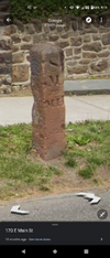
Here's Streetview of the one on Kresson Rd, near Marlkress in Cherry Hill

Thank you. Whether it sunk or the land was built up around it, no idea. I would hazard a guess that the buried letters may refer to Camden, if you extend straight down Kresson Rd to Haddon Ave and continue on, 8 miles puts you in Camden.Here's Streetview of the one on Kresson Rd, near Marlkress in Cherry Hill
View attachment 19512
This text on the post appears similar to the post in Moorestown.
Last edited:
Probably natural build up of detritus has buried it.I"ve seen buried stones that were covered with duff stick up out of the ground a foot or more after a hot fire burnt the duff back down to mineral soil (Sand).They may be mowing the grass but leaving the old grass on the ground instead of sucking it up in bags.Thank you. Whether it sunk or the land was built up around it, no idea. I would hazard a guess that the buried letters may refer to Camden, if you extend straight down Kresson Rd to Haddon Ave and continue on, 8 miles puts you in Camden.
This text on the post appears similar to the post in Moorestown.
Just a note, and not to continue diverting from the Stage Route; I am hypothesizing that the mile stone in Haddonfield may have been moved. Is this possible? Not sure how deep these things are anchored.
The one hand on the 'Camden" side of the marker points the right way, towards Camden. The "Glou" side of the marker points to Moorestown as I posted on Thursday.
To the best of my knowledge, the area up around Moorestown/Maple Shade was never known as Gloucester; however, if you were to find a place where the marker would work, distance wise, between the two points, I'm estimating it would have had to be around Westville.
I initially thought Woodbury, given the age, but Woodbury is too far south from Camden for it to work. This is just an observation and hypothesis. I may be wrong.