
D'oh! Just realized I posted this in the general forum and not trip reports-mods please move-sorry!
I had a great weekend in the Pines Saturday and Sunday despite not having a lot of time and not being able to figure out exactly where we were some of the time. I think my Garmin Nuvi is not exactly up to the task of handling topographic maps unfortunately. It is old and maybe doesn't have enough memory/a fast enough processor? Frequently, when driving through the pines the map would go entirely blank and just show the vehicle icon, the mileage to the turn/destination, and the time of arrival. Basically it just seemed like it couldn't keep up with redrawing the map as we moved. Also, it seemed to want us to turn down roads that didn't exist, so I'm not sure if it was trying to route us over hiking trails that it thought were actual roads, or the roads exist on Boyd's map of NJ and there's just no trace of them any longer. I really need to do some research to find out what the best vehicle based GPS for off pavement navigation is-just a warning Boyd, I'll be PMing you to pick your brain") Nevertheless, it was just good to get some time in the woods and to camp with some good friends who I don't get to see often enough and had never been to the pines before.
Nevertheless, it was just good to get some time in the woods and to camp with some good friends who I don't get to see often enough and had never been to the pines before.
First of all I'd like to give a great review to Pilgrim Lake Campground which located here:
http://goo.gl/maps/aNx7O
The office sits at the corner of Stage Road and Allen Road. The entrance to the sites is further up Allen Road (before it gets bad-more on that later)-they put us on the far north side of the campground and we had no one around us. The property is heavily wooded and they only really clear enough space for some tents, a fire ring, and a picnic table-that's it. There were sites adjacent and across the road from us but there was nothing but woods behind us:
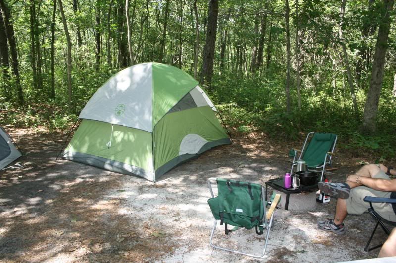
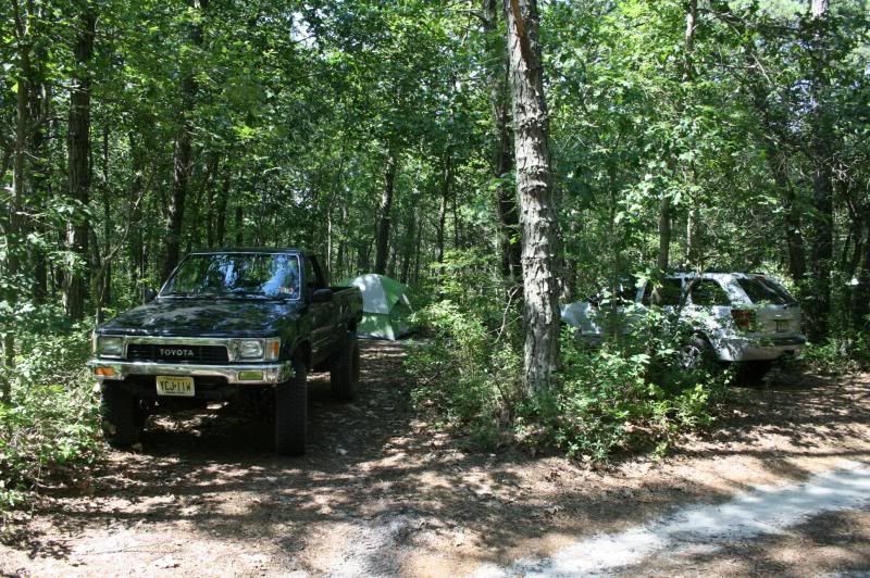
That combined with the fact that our area of the campground was deserted made it feel almost like we had driven deep into bass river and just set up camp on the side of the road. Helen and Scott, the owners, live on site and were really great. The prices are also really reasonable at $30 a night for a tent site, and $10 for a wheelbarrow load of good dry firewood. We arrived and set up at about 11:30 and then headed into the woods. There is a small lake for swimming but we didn't partake, so no report on that, but all in all we were very happy with it and would definitely stay there again. It's a very no frills campground-no swimming pools, no basketball courts, no organized activities, etc... Just a nice peaceful place to camp in a natural setting (ie: not a mowed field with no shade). For many of you on here who live in the area I know you really don't have much use for a campground, but for any NJPinebarrens users who come from 2+ hours away like I do, I highly recommend Pilgrim Lake.
The plan was to find Calico Ridge and do some swimming there. We entered the woods from Chatsworth Road via Civilian Conservation Corps Road. After merging with Calico Road and being told to turn left by the GPS at a spot where we were sure there was not even a hiking trail let alone a road we continued on to the intersection where Calico Road makes a hard left. We eventually wound our way to the area of Martha furnace and stopped first at the beach to the north:
http://goo.gl/maps/QpWUh
There was a group of kayakers having a picnic lunch there so we decided to try to continue on in the opposite direction to Calico Ridge thinking that there might be a good spot to swim there or some remnants of the old campground that might be interesting. We parked in this vicinity and got out and tried to find a way down to the water. It was at this point that I realized I had left my camera sitting in my backpack at camp Not that I found a lot to take pictures of anyway. The other issue was that we were pressed for time-the whole reason for camping in the pines was that we were attending a bachelor party starting at 5:30 (it was getting on 2:00 at this point) in Atlantic City that night but didn't want to pay big $$$ for a hotel room or participate in some of the wilder shenanigans that our younger (and unmarried) buddies were planning on. After poking around for a while and finding a few paths that led down to the water we determined that the only easy access was to a part of the pond that was full of weeds and mud-not really a great swimming hole. Oddly enough, when I scrambled down the ridge on one of the paths I found dirt that was held back with some kind of erosion control fabric near the bank of the river that didn't look that old. I suppose it could have dated back to when the site was in operation? I wish I had gotten a picture of it. Anyway, now looking at the same area in Bing Maps with their Bird's Eye imaging, I'm kicking myself that we didn't try harder to find a path to clear water:
http://binged.it/14dPSt5
It would have been nice to swim to one of those islands. Instead we headed back to Martha Bridge and parked near where we saw the kayakers before. They were still there so we ended up walking to Martha Bridge and doing some "renegade swimming" there. The cedar water was cool and refreshing, and the Oswego was running swiftly. Some of the kayakers seemed to take a dim view of the fact that we were swimming given the looks that were cast our way, but we stayed out of their way in a cool, deep eddy not far from the bridge. After about 45 minutes we dried off and headed back to camp to get cleaned up. Not that anyone would care much about the party itself, but we had a nice dinner and then hit the casino. I'm not a big gambler, but I do like blackjack and managed to turn $70 into $250 so I was pretty pleased with myself. That covered the cost of dinner, the campground, the food and beer I brought, and gas, so it worked out nicely After cashing out we headed back to camp and arrived at about 11:30 where Yuengling and bratwurst cooked over an open fire was consumed.
On Sunday we rose at about 6:30, cooked some bacon, eggs, and coffee and packed up to leave. The two friends I camped with had a long drive ahead of them back to Bergen County so they headed straight home. I decided to head out on my own, since my travels the day before had to be limited to where my buddy's 2012 Jeep Cherokee wouldn't be at risk of getting scratched. I made a right out of the campground and headed north on Allen Road, against the advice of a member here. I guessed that the bad road conditions wouldn't last that long-boy was I wrong! I thought my fillings were going to rattle out of my head:
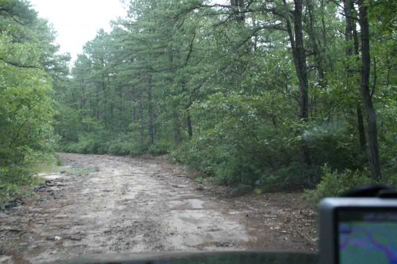
Does anyone know what the story of Allen Road is? Obviously it was paved at one time. However it doesn't look as if the state simply let it go-it looks like they actually broke up the pavement with a machine. What they ought to do is run a grader over it to at least get rid of the blacktop chunks which make for a harrowing ride. I did pass through a pleasant stand of cedars in a boggy area which I believe was at Bartlett's Bridge?
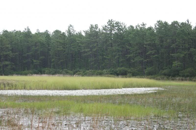
I continued on and stopped again to take a photo of this pond on the east side of the road:
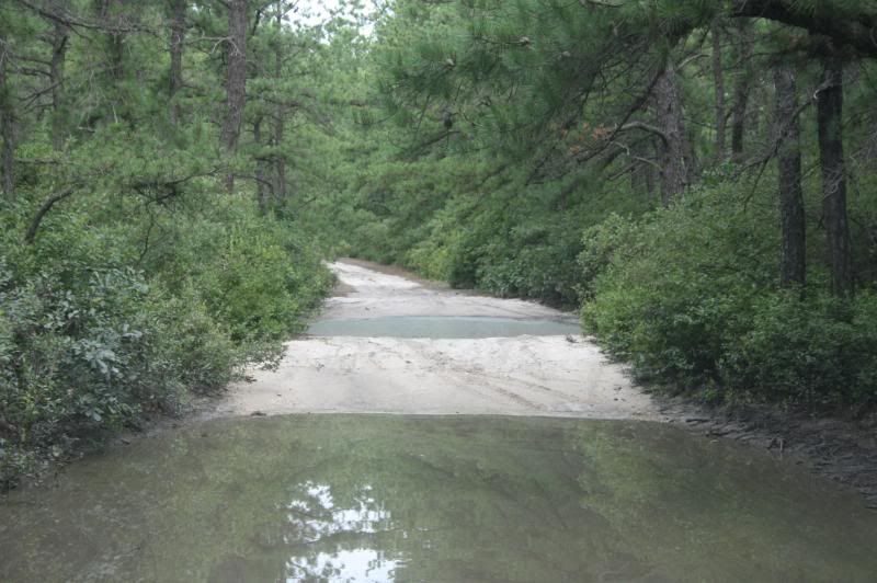
I continued (for what seemed like an eternity) north on Allen hoping that it would soon get better, which it did in spots, but then reverted to it's awful bombed out condition. I found a left turn and tried to take it in hopes of escaping the pounding of Allen Road, but ran into this:
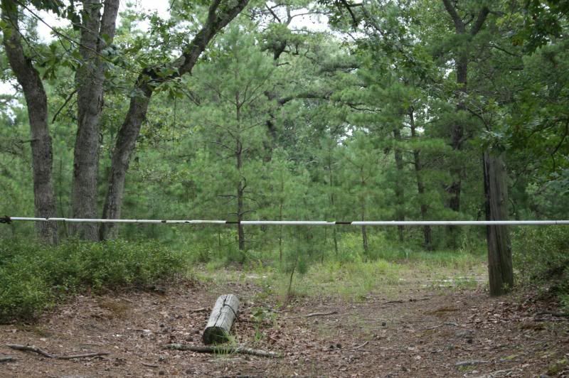
Thankfully I am much older and wiser now and wouldn't think of trying to traverse holes like that alone whether I gauged them with a branch or not. Ten years ago I probably would have. I turned (grudgingly) back onto Allen and prayed that I'd find another way out. That's when the wheels came off (not literally, though it felt like that might happen ) with regard to navigating. I ran into the barricade and then wondered what the heck to do next:
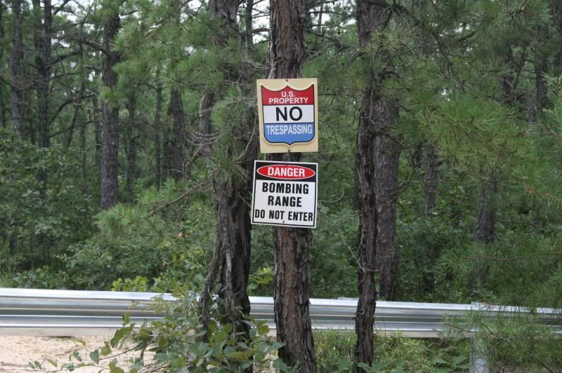
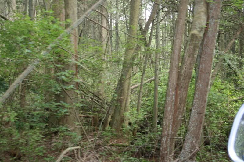
Interestingly the signs and guardrail all looked very new. The steel gate in the center did not. I don't recall where this gate was exactly so if someone could tell me so that I could plot it in Basecamp that would be helpful for next time. The mere thought of going back down Allen made my kidneys ache, so I was determined to find another way out to pavement, besides, I was due home at 1:00 p.m. it was about 10:40-I had to be headed north by 11:00 a.m. at the latest. I turned around and headed south on Allen for the first right turn I could find (I don't really remember where) and ended up getting into some trails which, as far as I could tell, aren't even on Boyd's map-either that or my GPS started to malfunction badly. I ended up winding my way down some pretty narrow trails, many that looked as they hadn't been traversed in a while, save for a few that had motorcycle tracks. At one point I climbed fairly high-I could feel myself climbing and as the map on the GPS went in and out I could see the elevation climbing. I think the road topped out at about 110' above sea level before I began to descend. The trails were very tight and I picked up some new pinestriping. In addition, without the ground clearance and short wheelbase my single cab Toyota has, I think I would have high centered at some point. For long stretches the trail was like a wavy ocean-what dirtbike riders would refer to as "whoops." I snapped this photo but it really doesn't convey how uneven the trail was-it felt like being on a boat in the ocean when there are 3'-4' swells:
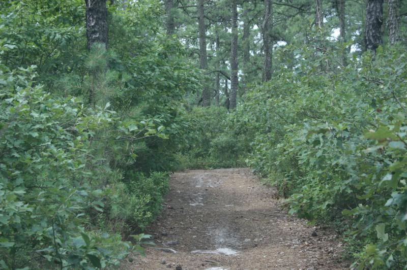
The other weird thing is that it seemed like they must have been man made? I don't see how they would form naturally? I guessed that maybe some dirtbike riders had dug out troughs in the trail to make the riding more interesting some years ago, but who knows. I wish I had more time to get out and look around because it was a very interesting area. I also wish I could see on the map where I had been, so if anyone wants to hazard a guess and try to figure out how I got from Point A (Allen Road) to Point B (Where Martha Road hits Chatsworth Road) I'd be grateful! I suppose it's possible that I took Oswego Road headed west from Allen, and then turned right (northeast) onto Shamong. The elevation changes on Shamong matched what I was seeing on the contour lines of the map, but for some reason the map wasn't giving me road names, it eventually just froze on "Continue to Route 72" and said something like 18 miles If I did go that way I guess I eventually turned onto Martha Road and eventually took it all the way to Chatsworth Road. I snapped this picture on the side of the road at one point-if I was headed South (which I must have been), this gate would have been on the west side of the road:
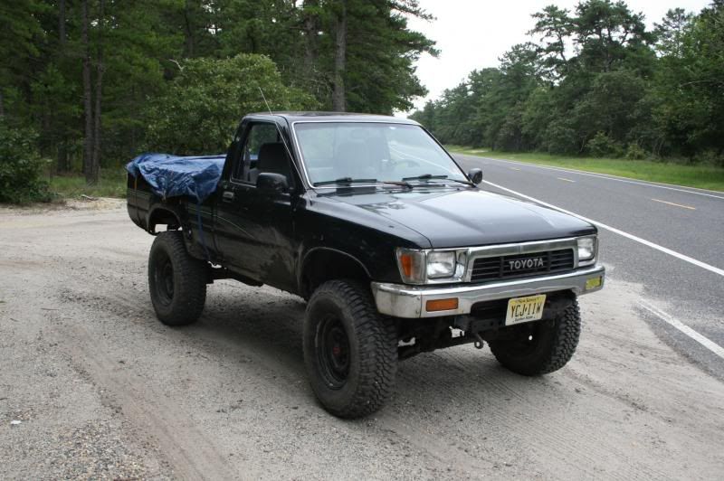
After descending the hill things began to get a little desperate-my GPS was useless, I was up against the deadline to be making tracks for home, and I seemed to be traveling through some wet bottomlands. I just had to go for it with every puddle I saw from there on out-gritting my teeth and doing my best to chug through with enough power to get me to the other side but not enough to spin my wheels. Though most puddles looked worse then they actually were, I was grateful for the 15" of ground clearance at my front crossmember and my 32" MTs. Finally, at about 11:05 I hit pavement, hopped out, unlocked the hubs, and headed for home:
The tarp was covering my camping gear because I had talked to my wife earlier in the day and she told me it had been pouring on and off since 5:00 a.m. I suppose I might have looked suspicious to a ranger or park police officer had I encountered one (I didn't the entire weekend). Sure enough, it started to rain just as I hit the Flemington Circle. All in all we had a great trip and my "city boy" (born and raised in Jersey City, now living in Bergen County) buddies had a great time as they had never been in the pines or on unpaved roads before. I have the bug to explore Bass River now more than ever! It seems that the roads (at least the ones I traveled yesterday) don't get much use and the 4x4 crowd sticks more to Wharton. I saw very little, if any trash, no dump sites, and very little impact on the roads other than the occasional tire tracks. The holes didn't seem overly rutted and didn't swallow my truck alive. Whatever the reason this area of Bass River is like this, I sure hope it stays that way. Now that I think of it though, as I was cooking breakfast at the campsite Sunday morning I did see/hear at least two or three trucks trailering what looked like dirtbikes or ATVs down Allen Road faintly through the woods. Our site was directly across a small strip of woods from Allen. I didn't make my way down Allen until about four hours later and I saw no sign of them the entire time I was in the woods so I don't know where they went.
It's a long read, but I hope that others who are better navigators and more knowledgeable than I can help me fill in the gaps where my skills and equipment failed me. When I return to Bass River I hope to find the prime swimming/picnicking spots at Calico Ridge as I'd love to take my wife and daughter out there on a nice day among other things. Thanks for reading.
I had a great weekend in the Pines Saturday and Sunday despite not having a lot of time and not being able to figure out exactly where we were some of the time. I think my Garmin Nuvi is not exactly up to the task of handling topographic maps unfortunately. It is old and maybe doesn't have enough memory/a fast enough processor? Frequently, when driving through the pines the map would go entirely blank and just show the vehicle icon, the mileage to the turn/destination, and the time of arrival. Basically it just seemed like it couldn't keep up with redrawing the map as we moved. Also, it seemed to want us to turn down roads that didn't exist, so I'm not sure if it was trying to route us over hiking trails that it thought were actual roads, or the roads exist on Boyd's map of NJ and there's just no trace of them any longer. I really need to do some research to find out what the best vehicle based GPS for off pavement navigation is-just a warning Boyd, I'll be PMing you to pick your brain
Nevertheless, it was just good to get some time in the woods and to camp with some good friends who I don't get to see often enough and had never been to the pines before.First of all I'd like to give a great review to Pilgrim Lake Campground which located here:
http://goo.gl/maps/aNx7O
The office sits at the corner of Stage Road and Allen Road. The entrance to the sites is further up Allen Road (before it gets bad-more on that later)-they put us on the far north side of the campground and we had no one around us. The property is heavily wooded and they only really clear enough space for some tents, a fire ring, and a picnic table-that's it. There were sites adjacent and across the road from us but there was nothing but woods behind us:
That combined with the fact that our area of the campground was deserted made it feel almost like we had driven deep into bass river and just set up camp on the side of the road. Helen and Scott, the owners, live on site and were really great. The prices are also really reasonable at $30 a night for a tent site, and $10 for a wheelbarrow load of good dry firewood. We arrived and set up at about 11:30 and then headed into the woods. There is a small lake for swimming but we didn't partake, so no report on that, but all in all we were very happy with it and would definitely stay there again. It's a very no frills campground-no swimming pools, no basketball courts, no organized activities, etc... Just a nice peaceful place to camp in a natural setting (ie: not a mowed field with no shade). For many of you on here who live in the area I know you really don't have much use for a campground, but for any NJPinebarrens users who come from 2+ hours away like I do, I highly recommend Pilgrim Lake.
The plan was to find Calico Ridge and do some swimming there. We entered the woods from Chatsworth Road via Civilian Conservation Corps Road. After merging with Calico Road and being told to turn left by the GPS at a spot where we were sure there was not even a hiking trail let alone a road we continued on to the intersection where Calico Road makes a hard left. We eventually wound our way to the area of Martha furnace and stopped first at the beach to the north:
http://goo.gl/maps/QpWUh
There was a group of kayakers having a picnic lunch there so we decided to try to continue on in the opposite direction to Calico Ridge thinking that there might be a good spot to swim there or some remnants of the old campground that might be interesting. We parked in this vicinity and got out and tried to find a way down to the water. It was at this point that I realized I had left my camera sitting in my backpack at camp
Not that I found a lot to take pictures of anyway. The other issue was that we were pressed for time-the whole reason for camping in the pines was that we were attending a bachelor party starting at 5:30 (it was getting on 2:00 at this point) in Atlantic City that night but didn't want to pay big $$$ for a hotel room or participate in some of the wilder shenanigans that our younger (and unmarried) buddies were planning on. After poking around for a while and finding a few paths that led down to the water we determined that the only easy access was to a part of the pond that was full of weeds and mud-not really a great swimming hole. Oddly enough, when I scrambled down the ridge on one of the paths I found dirt that was held back with some kind of erosion control fabric near the bank of the river that didn't look that old. I suppose it could have dated back to when the site was in operation? I wish I had gotten a picture of it. Anyway, now looking at the same area in Bing Maps with their Bird's Eye imaging, I'm kicking myself that we didn't try harder to find a path to clear water:http://binged.it/14dPSt5
It would have been nice to swim to one of those islands. Instead we headed back to Martha Bridge and parked near where we saw the kayakers before. They were still there so we ended up walking to Martha Bridge and doing some "renegade swimming" there. The cedar water was cool and refreshing, and the Oswego was running swiftly. Some of the kayakers seemed to take a dim view of the fact that we were swimming given the looks that were cast our way, but we stayed out of their way in a cool, deep eddy not far from the bridge. After about 45 minutes we dried off and headed back to camp to get cleaned up. Not that anyone would care much about the party itself, but we had a nice dinner and then hit the casino. I'm not a big gambler, but I do like blackjack and managed to turn $70 into $250 so I was pretty pleased with myself. That covered the cost of dinner, the campground, the food and beer I brought, and gas, so it worked out nicely
After cashing out we headed back to camp and arrived at about 11:30 where Yuengling and bratwurst cooked over an open fire was consumed.On Sunday we rose at about 6:30, cooked some bacon, eggs, and coffee and packed up to leave. The two friends I camped with had a long drive ahead of them back to Bergen County so they headed straight home. I decided to head out on my own, since my travels the day before had to be limited to where my buddy's 2012 Jeep Cherokee wouldn't be at risk of getting scratched. I made a right out of the campground and headed north on Allen Road, against the advice of a member here. I guessed that the bad road conditions wouldn't last that long-boy was I wrong! I thought my fillings were going to rattle out of my head:
Does anyone know what the story of Allen Road is? Obviously it was paved at one time. However it doesn't look as if the state simply let it go-it looks like they actually broke up the pavement with a machine. What they ought to do is run a grader over it to at least get rid of the blacktop chunks which make for a harrowing ride. I did pass through a pleasant stand of cedars in a boggy area which I believe was at Bartlett's Bridge?
I continued on and stopped again to take a photo of this pond on the east side of the road:
I continued (for what seemed like an eternity) north on Allen hoping that it would soon get better, which it did in spots, but then reverted to it's awful bombed out condition. I found a left turn and tried to take it in hopes of escaping the pounding of Allen Road, but ran into this:
Thankfully I am much older and wiser now and wouldn't think of trying to traverse holes like that alone whether I gauged them with a branch or not. Ten years ago I probably would have. I turned (grudgingly) back onto Allen and prayed that I'd find another way out. That's when the wheels came off (not literally, though it felt like that might happen
) with regard to navigating. I ran into the barricade and then wondered what the heck to do next:
Interestingly the signs and guardrail all looked very new. The steel gate in the center did not. I don't recall where this gate was exactly so if someone could tell me so that I could plot it in Basecamp that would be helpful for next time. The mere thought of going back down Allen made my kidneys ache, so I was determined to find another way out to pavement, besides, I was due home at 1:00 p.m. it was about 10:40-I had to be headed north by 11:00 a.m. at the latest. I turned around and headed south on Allen for the first right turn I could find (I don't really remember where) and ended up getting into some trails which, as far as I could tell, aren't even on Boyd's map-either that or my GPS started to malfunction badly. I ended up winding my way down some pretty narrow trails, many that looked as they hadn't been traversed in a while, save for a few that had motorcycle tracks. At one point I climbed fairly high-I could feel myself climbing and as the map on the GPS went in and out I could see the elevation climbing. I think the road topped out at about 110' above sea level before I began to descend. The trails were very tight and I picked up some new pinestriping. In addition, without the ground clearance and short wheelbase my single cab Toyota has, I think I would have high centered at some point. For long stretches the trail was like a wavy ocean-what dirtbike riders would refer to as "whoops." I snapped this photo but it really doesn't convey how uneven the trail was-it felt like being on a boat in the ocean when there are 3'-4' swells:
The other weird thing is that it seemed like they must have been man made? I don't see how they would form naturally? I guessed that maybe some dirtbike riders had dug out troughs in the trail to make the riding more interesting some years ago, but who knows. I wish I had more time to get out and look around because it was a very interesting area. I also wish I could see on the map where I had been, so if anyone wants to hazard a guess and try to figure out how I got from Point A (Allen Road) to Point B (Where Martha Road hits Chatsworth Road) I'd be grateful! I suppose it's possible that I took Oswego Road headed west from Allen, and then turned right (northeast) onto Shamong. The elevation changes on Shamong matched what I was seeing on the contour lines of the map, but for some reason the map wasn't giving me road names, it eventually just froze on "Continue to Route 72" and said something like 18 miles
If I did go that way I guess I eventually turned onto Martha Road and eventually took it all the way to Chatsworth Road. I snapped this picture on the side of the road at one point-if I was headed South (which I must have been), this gate would have been on the west side of the road:
After descending the hill things began to get a little desperate-my GPS was useless, I was up against the deadline to be making tracks for home, and I seemed to be traveling through some wet bottomlands. I just had to go for it with every puddle I saw from there on out-gritting my teeth and doing my best to chug through with enough power to get me to the other side but not enough to spin my wheels. Though most puddles looked worse then they actually were, I was grateful for the 15" of ground clearance at my front crossmember and my 32" MTs. Finally, at about 11:05 I hit pavement, hopped out, unlocked the hubs, and headed for home:
The tarp was covering my camping gear because I had talked to my wife earlier in the day and she told me it had been pouring on and off since 5:00 a.m. I suppose I might have looked suspicious to a ranger or park police officer had I encountered one (I didn't the entire weekend). Sure enough, it started to rain just as I hit the Flemington Circle. All in all we had a great trip and my "city boy" (born and raised in Jersey City, now living in Bergen County) buddies had a great time as they had never been in the pines or on unpaved roads before. I have the bug to explore Bass River now more than ever! It seems that the roads (at least the ones I traveled yesterday) don't get much use and the 4x4 crowd sticks more to Wharton. I saw very little, if any trash, no dump sites, and very little impact on the roads other than the occasional tire tracks. The holes didn't seem overly rutted and didn't swallow my truck alive. Whatever the reason this area of Bass River is like this, I sure hope it stays that way. Now that I think of it though, as I was cooking breakfast at the campsite Sunday morning I did see/hear at least two or three trucks trailering what looked like dirtbikes or ATVs down Allen Road faintly through the woods. Our site was directly across a small strip of woods from Allen. I didn't make my way down Allen until about four hours later and I saw no sign of them the entire time I was in the woods so I don't know where they went.
It's a long read, but I hope that others who are better navigators and more knowledgeable than I can help me fill in the gaps where my skills and equipment failed me. When I return to Bass River I hope to find the prime swimming/picnicking spots at Calico Ridge as I'd love to take my wife and daughter out there on a nice day among other things. Thanks for reading.
