Tyndall Island Hike, Large Scat

4x4Jim

Scout
Jan 20, 2006
55
0
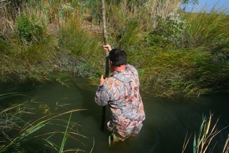
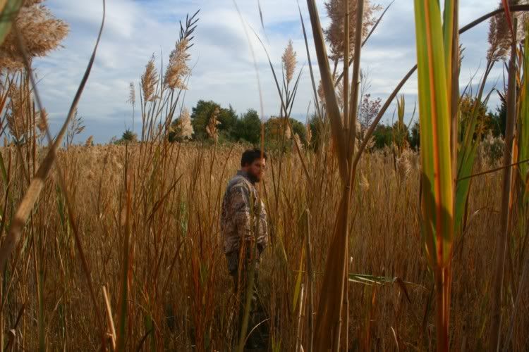
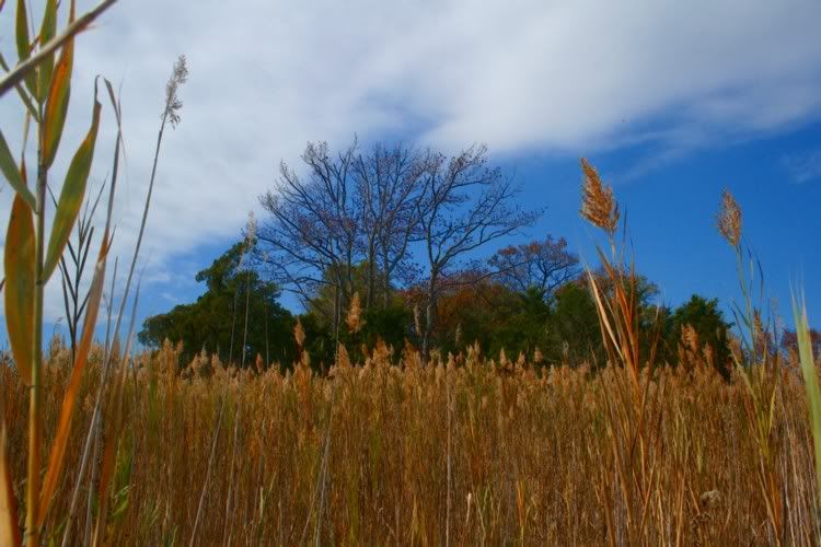
Hey all been dormant for a while. Friend and I went for an adventure hike to the far reaches of Tyndall island today(This will be our 5th time there) got a late start and found ourselves wading through chest high water to get to the entrance of the large part of the island(s). Hiked through the thick brush and ice laden bogs. Our goal was to hit the very far reaches of the island chain that ive been researching through google earth and another site from images of 1930. Made it almost there and due to the time had only about 45 mins to explore before the sunlight left us. Saw a huge amount of game trails, poo, osprey nests, turtle shells, and a very largeee pile of scat. It was very strange to us and got us thinking about what could make such a large pile of poo. Ive researched it and narrowed it down to one very unlikely candidate, and one likely candidate. It looks like bear scat to a T and also raccoon scat. But for it to be coon scat it would have to have been visited multiple times called a Latrine where they go over and over again. The only problem with that is that it looks like one solid mass not a couple different masses. And it appeared fresh. Heres the pic.
poop.jpg

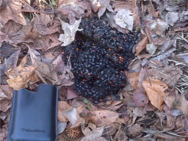
It got nice and dark by the time we got back over the water crossing and the nightlife really came out. Owls, strange crying birds with large vocals, and something that freaked us out a bit. A screaming cry resembling a woman. In the distance behind us quite loud, stopped and listened for a while. Nighthawk? not sure but it was strange to say the least. Tyndall island is a pristine wildlife arean and some places we walked back there im sure hasn't been touch since colonial times. Were headed out early tomorrow to say the least. Any info on the scat is appreciated. Ive also tried to research Tyndalls Island and have found very little info. Can anyone shed more light? I know it goes back to colonial times. Storied of pirates landing at the mouth of Stow creek and reaking havoc on the residents live stock are factual.
 

Kevinhooa

Explorer
Mar 12, 2008
332
25
41
Hammonton, NJ.
www.flickr.com
That really, really looks like bear poo. And the screaming was most likely a fox. They have one heck of an insane way of letting their presence be known. And in the dark, that screech will make you leave a similar pile to the bears you found! Sorry, no info on that island for you though.
 

manumuskin

Piney
Jul 20, 2003
8,552
2,465
59
millville nj
www.youtube.com
been there a few times myself.did you find the small cellar hole out at the end of it? did you see the concrete monument just as you head off the old road to the island proper? at low tide you can walk across the logs at the bottom of the tidal ditch and stay dry but you only have an hour or so to get vback out before the logs are covered and the waters rise.at high tide your looking at about shoulder deep water.
that area is one of my favorites,biggest deer in south jersey live on the salt medder islands.
I'd personally say thats one fat coon layed that pile but will never say a bear poo is impossible.problem being it can't support itself indefinitely on the island and once it comes off the island it's all farms with very little in the way of cover or at this time of year,grub and bringing that up that looked like fresh poo and normally a bear would be sleeping this time of year though a midwinter wander is not unknown since they don't truly hibernate but just sleep heavy and often wake up and take short strolls in warm weather.
Al
 
Ive also tried to research Tyndalls Island and have found very little info. Can anyone shed more light? I know it goes back to colonial times. Storied of pirates landing at the mouth of Stow creek and reaking havoc on the residents live stock are factual.

Jim:

Here is some quick history of Tindall’s Island:

Tyndall’s or Tindall’s Island, takes its name from Richard Tindall, its first English owner. Tindall arrived in the New World in 1678 and established his primary plantation as Tindall’s Bowery in the Mannington Precinct, Salem County, and within John Fenwick’s Salem Tenth. By the mid-1680s, he served as an executor of John Fenwick’s estate and also held the office of Surveyor General for the Salem Tenth. Tindall died during January 1698 and his estate inventory included “100 a. at Cohansey, called Tindalls Island, valued at £8 sterling. The property eventually passed out of the family to other owners. The island stood in an area known as Bacon’s Neck.

On the eve of the American War for Independence, Tindall Island became a battlefield. In a letter written from Cumberland County by an American militia officer on 6 May 1776, he wrote:

This serves to inform you of an alarm we had about eleven o’clock this day, of a party of regulars, landing on Tindall’s Island in Bacon’s Neck, about four miles from Greenwich; supposed to be about thirty in number; shooting down the cattle, taking them on board, &c., whereupon I called the militia together as soon as possible, and upon our appearance, a gun was fired from on board one of the vessels, for them to repair on board, which they did with the greatest precipitation. Our men pursued so closely that we were near taking three of them prisoners, one of whom left an excellent musket behind we got with some cartridges.

They hollowed to our men to go on board the King Fisher, and they would pay for the beef. It is supposed they took off between 20 and 30 head of cattle, 5 they left dead on the shore, and wounded many others, which with all the others we have drove from the water side. They have taken this morning a shallop belonging to Daniel Richards, bound from Philadelphia to Morris [Maurice] river, but the hands escaped to shore.” Pennsylvania Journal and Weekly Advertiser.


In a follow-up story to the one above, the 11 May 1776 edition of The Pennsylvania Ledger reported:

By a Gentleman from Greenwich, in Cumberland County, New Jersey, we learn, that on Monday last, about 10 o’clock, a body of men from the pirate ships landed on Tindon’s Island, between Cohansey Creek and Stow Creek; that they shot down and carried off between 20 and 30 cattle from the marsh; that the militia mustered together as fast as possible, and marched down to engage them, but being discovered from the ships, a signal was given, and the men took to their boats with great precipitation, leaving five dead cattle on the shore; one of the men was so closely pursued that he dropt his musket, and narrowly escaped being taken. The ships immediately weighed anchor and stood up the river.

Whether these marauders were truly pirates or just British sailors and troops gathering forage is unknown to this author.

Almost 70 years to the day after this incident, the New Jersey State Legislature approved a law enabling “…the owners of a tract of marsh and upland on the upper side of Cohansey Creek, to make, amend and keep in good repair, Tindall’s Island Causeway” (P.L. 1857:96-99).

By 1876, a James Griffith owned 38 acres of the island according to the 1876 Stewart atlas of Cumberland County.

Some years ago, avocational archaeologists found an intact circa 1750 Wistarburg glass mug on the island.

Best regards,
Jerseyman
 

4x4Jim

Scout
Jan 20, 2006
55
0
Thanks guys that's basically most of the info Im aware of also. Rumor has it there was a large asparagus farm on the islands. In the 1930 map you can see what looks like farm land on all the islands that are now covered in dense trees. I still have yet to see a deer out there but there sure is plentyyy of signs. Ya bear is unlikely, but possible. Humongous raccoon makes more sense but still freaky when your only armed with a machete. Im still unaware of the cellar hole. Havnt found that yet. Where exactly do you mean by in the back. Do you mean the end of the island chain? Through the marshes to the next set of 2 "islands"? Or at the end if you go straight through to the end of the marsh where the old cables lie on the hill that runs through. I wonder how many people actually have been out the ends of the island. And how far it would take to get to the beach in the article. Im going to try and find out tomorrow. Im aware of a man who found an old british gold coin out somewhere on the islands. Very remote area and beautiful.
 

lakesgirl

Explorer
Jan 3, 2010
133
0
collings lakes
thanks Jerseyman for the info about the island. Was out there late last summer. Did a little wandering around the area. Came across a very large black snake and a kestrel trying to grab a very large woodpecker out of a tree. I think the kesrtel's eyes were bigger than it's stomach...because the woodpecker was larger thanthe kestrel. Boy, did that woodpecker make a ruccuss!

I tend to think the scat is a very large raccoon.
 

Frolickin

Explorer
Apr 21, 2003
149
0
Millville, NJ
rdowens.net
I love this area. It would seem an unlikely place for a bear, although anything is possible.

To avoid the chest-high water, check the tides for Tindalls Wharf. The crossing where the road is washed out becomes far easier when the tide is out.

I found a benchmark out there once.

3336205783_38787e4513.jpg


You mentioned the far reaches. Did you negotiate the dike? While passage can be tough, there is another island

3696268072_c01a012ef2.jpg


once you find the social trail.

3695457867_422f05a992.jpg
 

manumuskin

Piney
Jul 20, 2003
8,552
2,465
59
millville nj
www.youtube.com
that far island is Tindall island.the first apparent island is just the causeway.the cellar hole is all the way at the end of tindalls island which by the way is kind of two islands.the social tgrail you show is a deer/human trail that heads to the island and then that island ends and you have to cross a small medder to the big island which is several hundred yards long and at the end in the middle is a small cellar hole.I forget what the asonry in it is composed of.I believe old concrete but not sure.
Thanks for the history Jerseyman.I'd go with pirates in a small boat but then again them british do like their beef too.
Al
 

whippoorbill

Explorer
Jul 29, 2003
675
121
65
Bridgeton
I love this area. It would seem an unlikely place for a bear, although anything is possible.

To avoid the chest-high water, check the tides for Tindalls Wharf. The crossing where the road is washed out becomes far easier when the tide is out.

I found a benchmark out there once.

We saw the same benchmark during a recent visit.

This is the spot where the tide will getcha. Virtually no water here when crossing while heading out. It couldn't have been much more than an hour later when we faced this.
tyndallj.jpg


tyndallg.jpg


A couple of trip reports and other photos from T.I. are on the Bay Days thread in the photographers forum, if interested. It's nice out there.

tyndallh.jpg
 

4x4Jim

Scout
Jan 20, 2006
55
0
Hey left for Tyndalls about 8 am and stayed all day. Hiked to the very last island on the chain with is not a hop skip and jump. We hiked all the way to the end and even tried to traverse the marsh and hit the beach. A large creek stood in our way and we were already dog tired from all the muck and sinkholes to get to that point. I am confident I know these islands well enough now to get around. Frolickin I pass by the geodetic eveytime we go out. There is a shortcut at low tide though. Immediately after the water crossing head straight for the island on the marsh and follow the game trails. much easier. After the large second island there is a 3rd and 4th tucked way back. I still would love to know who lived back there. I can not find a single piece of information on its inhabitants. Great time and Ill be sure to return. Feeling a sick day soon =) Still have yet to see a deer though. So many signs, so no sightings.
 

manumuskin

Piney
Jul 20, 2003
8,552
2,465
59
millville nj
www.youtube.com
the cellar hole is approximately here
39.362776
74.378183
there are also a couple of nice small islands nearby which are also PSE&G land.
here
39.373305
74.386456
and
39.376716
74.389690
the last island is quite high and has evidence of an old camp on it.they can be walked to with a little medder finesse
on second thought the cellar hole may have been here
39.369588
74.376408
wherever it appears the island ends and the woods get real thick as if your approaching the end of the island.i think I went completely around the u shaped cove but not sure and didn't have a gos at the time and hence no track.if the open woods shuts down on you once your on the big island then your at the cellar hole.it's about 3 ft deep and about 6 ft aacross if i remember right.
frolickin,I never seen that outhouse remains.do you have a coordinate for that?
Al
 

manumuskin

Piney
Jul 20, 2003
8,552
2,465
59
millville nj
www.youtube.com
The outhouse is right near the benchmark. It sits on the opposite side of the dike. This leads me to believe this area was more than just a road.

i must have seen it then but just don't remember it.were you out there benchmark hunting or just checking out the island? the benchmark caught me by surprise.it's not on the topo that I remember.
Al
 

Frolickin

Explorer
Apr 21, 2003
149
0
Millville, NJ
rdowens.net
i must have seen it then but just don't remember it.were you out there benchmark hunting or just checking out the island? the benchmark caught me by surprise.it's not on the topo that I remember.

I go out there to explore. It sounds like there is more for me to see. The benchmark caught me off guard too. I think I usually get off the dike earlier and just happened across it. The metal frame is in the same area.
 

rewdboy

New Member
Jan 25, 2010
4
0
43
poo?

sure is strang the way it looks so fresh yet there are some leaves over the pile. makes me wonder if it was fabricated. and its really not all that large
 

manumuskin

Piney
Jul 20, 2003
8,552
2,465
59
millville nj
www.youtube.com
I know you don't mean to accuse 4by 4 of being a fabricator of poo? That would even be worse then talking poo.I can bull poo with the best of em and even had a job once pumping poo for a septic company but never have I fabricated poo though I have fabricated steel,totally different process though.
Al
 

4x4Jim

Scout
Jan 20, 2006
55
0
Darn he got me! I gathered all the poo I could muster up and made a heaping mass.... Nah It wasnt fabricated. But I did find a tree/bush way back that had multiple piles of the same poo in smaller quantities. My money is definitely on the coons now. Nice tree to climb/hide. It just makes more sense than a bear. Manumuskin head straight when you cross the water and enter woods up to the right on the game trail. Youll see the metal stucture and the geo next to it. Theres also large cables running the length of the burm. Not sure what it was used for but it isnt that old. Im guessing im going to have to check the historical society for more factual info on the inhabitants.
 

amf

Explorer
May 20, 2006
152
45
Swedesboro
I believe a portion of the island(s) were used for a dredge disposal site. That iron structure could have been part of the outlet pipe.
 
Top