
View?
- Thread starter manumuskin
- Start date
You are using an out of date browser. It may not display this or other websites correctly.
You should upgrade or use an alternative browser.
You should upgrade or use an alternative browser.
Al, you are correct on reaching it from the south. It is an easy walk from Bamber. Funny, the misses and I always called it the Serengeti too. There is still a small hill there known as Preacher's Hill. It looks like that is where Guy's photos were taken. Its a really neat area and there is a pond in the middle that is usually loaded w wildlife in the warmer months. I got really pissed one year because someone stocks pheasant and chukars in that field sometime in autumn. I think its either the guys from the gravel pit, or maybe someone who knows Mr. Parker (ex-Lacey mayor and owns lots of land in the area). Anyway, I went back there one day and found a pile of about 15 birds that were shot and left in a pile to rot. Pretty scummy thing to do IMO.
That area north of 72 and east of 539 is the outback for me.have had a few memorable trips up that way,cedar creek is awesome and the smaller clear water sandy bottomed streams are great.The area seems to be even wilder and less peopled then the southern core area excepting once you start approaching Toms River.I was up by Jakes branch once and the woods were gorgeous but there was more trash dumped in the woods then I've even seen down here near Millville and Vineland.That area today i believe is a nature preserve.I should go back,I'm sure it's been cleaned up now.I'm going to have to get into that area more,I did a clandestine camp on chamberlin branch once,That might be the ticket to having a longer day up there.It's close to a two hour drive for me.
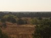
Hi. I am new to the site. Just took the photo to your left today. The "Serengetti" is beautiful and love Preacher Hill. I hiked in from the north. Bamber Lake. Took the trail that touches the outskirts of the sand pits and parallels the Chamberlain Branch that feeds Bamber. Beautiful 2.7 mile walk that ends with great reward. Can't believe this is in Lacey. We are lucky to have this in the Pine Barrens. Hope you all enjoy the pics to follow
nice pic's. it's starting to really look like fall. Hope we get some rain soon, grass is so dry a fire can flare up very easy.
I really must get there. Been all around it quite literally but have always missed it by at least a half a mile.
So were you near the factory branch(east or south)? Near the clearing to the south? or west near Aserdaten, in those hills?
It's a shame that the LIDAR coverage does extend that far East; it would reveal a lot more about topography than aerial photo's.
FWIW, the LIDAR coverage now includes this area. Here are the coordinates in Al's original post: http://boydsmaps.com/#lidar,39.863630,-74.321260,16
Bob
I was out there last year. I think you can see it in Guy's photo, isn't there a mailbox on one of the sand road intersections?
I think this is part of Brick Wall corp. Even back in the '70's I don't think a sand co. would venture on public or private land it didn't own. I think there's more to it than your assessment of "get the hell out of here" from the State. Maybe your right and Pinelands put a stop to it as they did that big proposed development in Manchester just West of the Lacey Line? You know where I'm talking about, Wynnwood I think, next to Roosevelt City?
I would think that hill comprised of the "right" sand and when the sand ran out so did the hill. That entire area just up from Bryant rd has been mined heavy and now left to reclaim itself. I haven't seen any Conservancy signs in this particular area, are you sure it's now their land? If Brick Wall can no longer mine there they may have sold or donated for a tax purpose since it would be worthless to them. It could have been a "peace" offering, here, you can have this, now leave us be.
These were posted all around the open field and much of the surrounding woods. I think it has been claimed by the F.R. Mountain Conservancy. Forgot to post this yesterday.
The first one was posted right at the fore front of my avatar picture. Also all around that field. It was right near an old mail box that looks like it hadnt been used in decades. No pic of that
saw alot of this out there also.
Looks like signs for Greenwood WMA.
Yes the Greenwood signs were posted to the right side of the trail when i was walking south on the east side of the Chamberlain Branch. I know alot of that land there from Lacey Rd to Webbs Mill and west of 539 are all Greenwood. I remember seeing them as far west as Chatsworth when I did my Apple Pie Hill trek 2 yrs ago.
Greenwood is a huge piece of land-I think more than 20K acres? So much exploring to be done there.