Wet Forest - Formerly Known as Dry Forest

Teegate

Administrator
Site Administrator
Sep 17, 2002
25,843
8,537
Got soaked to the bone at my daughter’s graduation in Hammonton. Not a drop at home in Atco though.
Reminds me of mine in 1975. Out in the far fields of Lenape and you could see the thunderstorm coming before the graduation even started. Some spectators started leaving early but most stayed until it started raining and the announcer told everyone to leave. A mad dash for the parking lot and everyone was soaked.
 
  • Like
Reactions: dragoncjo and Boyd

Boyd

Administrator
Staff member
Site Administrator
Jul 31, 2004
9,729
2,924
Ben's Branch, Stephen Creek
Haven't gone out yet, but looks completely dry and I didn't hear any rain all night.

[edit]Apparently there was some light rain overnight. Just enough to partially moisten the ground, at least it cut down on the dust. But it will quickly dry out in the heat of the day.
 
Last edited:

Boyd

Administrator
Staff member
Site Administrator
Jul 31, 2004
9,729
2,924
Ben's Branch, Stephen Creek
Of course, that could change with an extended dry spell, but we aren't there yet.
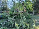
Apparently, it could change rather quickly. Note the "rapid onset drought risk" shaded area that includes Southern NJ. :siren:

Screen Shot 2024-06-15 at 5.52.55 AM.png
 
D

Deleted member 7363

Guest
I prefer the drier weather to the swampy weather. Not a lot of wind with these temps and it's super humid, but at least not rainy.
 

Boyd

Administrator
Staff member
Site Administrator
Jul 31, 2004
9,729
2,924
Ben's Branch, Stephen Creek
Rain on the way tomorrow night... forecast says 1/4 to 1/2 inch in Wharton, 1/2 to 3/4 inch down in my part of Atlantic County. Looks like just a rain event, without any strong winds.
 
  • Like
Reactions: enormiss

Teegate

Administrator
Site Administrator
Sep 17, 2002
25,843
8,537
Jessica's new weather station has top wind speed so far at 34, with the rain starting at 6:02 and so far we have had 75 lightning strikes within 4 miles. And we have had .03 inches or rain so far.
 
  • Like
Reactions: Boyd

Boyd

Administrator
Staff member
Site Administrator
Jul 31, 2004
9,729
2,924
Ben's Branch, Stephen Creek
NATIONAL WEATHER SERVICE MOUNT HOLLY NJ
537 PM EDT SUN JUN 23 2024

THE NATIONAL WEATHER SERVICE HAS EXTENDED SEVERE THUNDERSTORM
WATCH 449 TO INCLUDE THE FOLLOWING AREAS UNTIL 10 PM EDT THIS
EVENING

IN CENTRAL NEW JERSEY

MONMOUTH

IN NORTHERN NEW JERSEY

MIDDLESEX

IN SOUTHERN NEW JERSEY

ATLANTIC BURLINGTON CAMDEN
CAPE MAY CUMBERLAND GLOUCESTER
OCEAN SALEM

THIS INCLUDES THE CITIES OF ATLANTIC CITY, CAMDEN, CHERRY HILL,
DEPTFORD, EAST BRUNSWICK, EDISON, FREEHOLD, GLASSBORO, HAMMONTON,
MILLVILLE, MOORESTOWN, MOUNT HOLLY, NEW BRUNSWICK,
NORTH BRUNSWICK TOWNSHIP, OCEAN CITY, PENNSVILLE, PERTH AMBOY,
SAYREVILLE, AND TOMS RIVER.
 

Boyd

Administrator
Staff member
Site Administrator
Jul 31, 2004
9,729
2,924
Ben's Branch, Stephen Creek
Severe Thunderstorm Warning
NJC001-005-011-029-240145-
/O.NEW.KPHI.SV.W.0052.240624T0034Z-240624T0145Z/

BULLETIN - IMMEDIATE BROADCAST REQUESTED
Severe Thunderstorm Warning
National Weather Service Mount Holly NJ
834 PM EDT Sun Jun 23 2024

The National Weather Service in Mount Holly NJ has issued a

* Severe Thunderstorm Warning for...
Atlantic County in southern New Jersey...
Northeastern Cumberland County in southern New Jersey...
Central Ocean County in southern New Jersey...
Southeastern Burlington County in southern New Jersey...

* Until 945 PM EDT.

* At 834 PM EDT, severe thunderstorms were located along a line
extending from Chatsworth to Batsto to near Buena, moving east at
35 mph.

HAZARD...60 mph wind gusts.

SOURCE...Radar indicated.

IMPACT...Damage to roofs, siding, trees, and power lines is
possible.

* Locations impacted include...
Toms River, Vineland, Atlantic City, Barnegat, Pleasantville,
Hammonton, Beachwood, Brigantine, Absecon, Shamong, Buena, Egg
Harbor City, Tuckerton, Presidential Lakes Estates, Seaside
Heights, Weymouth, Estell Manor, Surf City, Port Republic, and
Elwood-Magnolia.

This includes the following highways...
Garden State Parkway between mile markers 37 and 84.
Atlantic City Expressway between mile markers 5 and 28.

PRECAUTIONARY/PREPAREDNESS ACTIONS...

For your protection move to an interior room on the lowest floor of a
building.

In addition to large hail and damaging winds, frequent cloud to
ground lightning is occurring with these storms. Move indoors
immediately. Remember, if you can hear thunder, you are close enough
to be struck by lightning.

&&

LAT...LON 3975 7407 3937 7436 3947 7503 3966 7479
3973 7474 3974 7475 3989 7468 4003 7403
TIME...MOT...LOC 0034Z 261DEG 30KT 3984 7454 3965 7467 3952 7489

HAIL THREAT...RADAR INDICATED
MAX HAIL SIZE...<.75 IN
WIND THREAT...RADAR INDICATED
MAX WIND GUST...60 MPH

$$

Screen Shot 2024-06-23 at 8.56.42 PM.png
 

Boyd

Administrator
Staff member
Site Administrator
Jul 31, 2004
9,729
2,924
Ben's Branch, Stephen Creek
Nothing here. My car was all dusty from drive through Peaslee yesterday, didn't bother to hose it down because I figured the storm would rinse it off. Stilll just as dusty this morning, literally not a drop of rain overnight. Was just in Mays Landing and they didn't have any rain there either, guess the line was somewhere around the AC Expressway? It's funny, the NWS got the rain forecast backwards - we were supposed to get the most rain in the South with less in the Northern Pines.

Spent awhile in the woods yesterday afternoon and evening. In spite of the heat, there was a nice breeze that never really let up and the humidity was only about 50% in the afternoon. Later, clouds started blocking the sun and it cooled down even more, but the overnight low was only 78. Wind never got very strong here.

Looks like the next chance for rain is Wed night, we could use some here. :)
 
Top