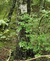
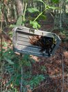
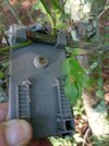
what is this item?

cattothepines

New Member
Jul 30, 2025
2
2
Toms River
hey guys, first post but been checking out this forum since I was a kid ages ago when i used to live next to sarco, and it's always been such a wealth of information. Now that i have my first car i've basically been living in the pines and combing through all the obscure parts of its history.

anyways for my question: was walking down a footpath off of hawkins bridge road, one of boyds maps calls it franks ford road? it was cool to see how the vegetation grows back in a place that has old parking areas and obviously used to be driven. i noticed an almost fully overgrown trail in one of the parking areas and decided to make my way through it, and came upon an old dried up bog looking spot with this object bolted to the tree. is it an old ccc thing, or something else? what is it even used for? i amused myself imagining it was a mailbox and a mailman having to climb through there, but that's obviously wrong haha. thanks!
 

Attachments

  • Screenshot 2025-08-01 180036.png
    Screenshot 2025-08-01 180036.png
    1.2 MB · Views: 94
  • Like
Reactions: Boyd

Teegate

Administrator
Site Administrator
Sep 17, 2002
26,480
9,433
I really don't know. It could be anything from a sign someone had there or something a hunter hung up. Maybe someone will have a better idea.
 
  • Like
Reactions: cattothepines

MuckSavage

Explorer
Apr 1, 2005
671
310
57
Turnersville
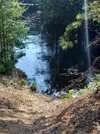
I walked the same trail & while I didn't see your object, there's another where the road would've crossed the river.
 

Attachments

  • KIMG20250802_084838041.JPG
    KIMG20250802_084838041.JPG
    2 MB · Views: 19
  • KIMG20250802_084847072.JPG
    KIMG20250802_084847072.JPG
    1.6 MB · Views: 18
  • Like
Reactions: RednekF350

Boyd

Administrator
Staff member
Site Administrator
Jul 31, 2004
10,322
3,327
Ben's Branch, Stephen Creek
Why would you jump to that conclusion? I mean... sure, it could be. But we have quite a few threads here about private citizens putting trail cameras on public land, including one from this suspicious individual... :D

I have had my game camera set over a pile of breasted-out snow goose carcasses in a very remote area of the pines for the last week.
 
  • Like
Reactions: RednekF350

RednekF350

Piney
Feb 20, 2004
5,190
3,609
Pestletown, N.J.
Why would you jump to that conclusion? I mean... sure, it could be. But we have quite a few threads here about private citizens putting trail cameras on public land, including one from this suspicious individual... :D
My quick conclusion was based on the fact that the poster said he found it on an old trail. Most hunters put their cameras over bait piles
I am usually spying on carniverous critters and I occasionally capture a head-scratching individual who stumbles across my carcass piles. I had a guy this year. He almost hit my camera with his leg as he walked by. He was going duck hunting. He was walking further down towards a stream with a small bag of decoys on his back.
 
  • Like
Reactions: Boyd

MuckSavage

Explorer
Apr 1, 2005
671
310
57
Turnersville
The camera I found was here (Franks Ford Rd actually goes to the riverbank.) I don't think the state, NJPP, PPA, etc would put a camera, but Everytime I see one of the brown plastic whips closing a trail that say "Video surveillance". I spend a few minutes looking for cameras & I've yet to find one.
1000003051.png
 
  • Like
Reactions: Boyd

Teegate

Administrator
Site Administrator
Sep 17, 2002
26,480
9,433
They may place a camera there because of the illegal swimming and parties that must go on there. But I doubt they do.

Btw, if anyone goes there you are not looking closely enough. There is a small piece of history in that area before you head into the swamp. And in September, if nobody damages them, you will see blue when at the water. Just saying!
 
  • Like
Reactions: Boyd

Boyd

Administrator
Staff member
Site Administrator
Jul 31, 2004
10,322
3,327
Ben's Branch, Stephen Creek
@cattothepines - it might be helpful to see exactly where you're talking about. The new USGS topo shows Franks Ford Road here and I used that name on my old topo map(s)

https://boydsmaps.com/#16.00/39.701560/-74.556553/ustopo2023/0.00/0.00

However, I recently noticed that the USGS legacy topo just calls it "Ford Road"

https://boydsmaps.com/#15.00/39.702287/-74.556360/legacy24k/0.00/0.00

So, I am using that name on my newer maps

https://boydsmaps.com/#15.00/39.702287/-74.556360/hybrid/0.00/0.00

Anyway, you can easily post a link to the exact spot at boydsmaps. Just drag the map until the crosshairs are over what you want, then click the share button - it's on the toolbar in the desktop version or the main menu in the mobile version.

share.png


Then just click the copy button and paste the link into your post here.
 
  • Like
Reactions: MuckSavage

MuckSavage

Explorer
Apr 1, 2005
671
310
57
Turnersville
Boyd, as I drove past today, the factory GPS in my Ram Promaster van (I think Tom Tom based) it calls the northerly road (closer to Hawkins Bridge) "Franks Ford Rd" and the southerly road as "Ford Rd".
 
  • Like
Reactions: Boyd

MuckSavage

Explorer
Apr 1, 2005
671
310
57
Turnersville
They may place a camera there because of the illegal swimming and parties that must go on there. But I doubt they do.

Btw, if anyone goes there you are not looking closely enough. There is a small piece of history in that area before you head into the swamp. And in September, if nobody damages them, you will see blue when at the water. Just saying!
You have me making a reservation for my favorite site at H-B for September!!!!!
 

Boyd

Administrator
Staff member
Site Administrator
Jul 31, 2004
10,322
3,327
Ben's Branch, Stephen Creek
Will be interesting to see the exact location. They called it a "old dried up bog looking spot" on an "almost fully overgrown trail". That doesn't really seem to describe your scenic location. :)
 

MuckSavage

Explorer
Apr 1, 2005
671
310
57
Turnersville
@Boyd who is they? Franks Ford Rd & Ford Rd seems like it was a normal sand road. I'll say that's it's been growing in since the road closed whips went up. If it wasn't for the "legal" reasons, I wouldn't hesitate to take my CJ7 all the way to the river. My Commander or the van are a lil too big.
 

Boyd

Administrator
Staff member
Site Administrator
Jul 31, 2004
10,322
3,327
Ben's Branch, Stephen Creek
Sorry. "They" is @cattothepines, who started this thread. They described the place where they saw this "item" on a tree and it doesn't seem to be what you are talking about. As I understood the post, it wasn't Franks Ford road, but an overgrown trail off of that road.

But their post is rather ambiguous, which is why I suggested they post an actual link so we don't have to guess where it is...

i noticed an almost fully overgrown trail in one of the parking areas and decided to make my way through it, and came upon an old dried up bog looking spot with this object bolted to the tree.
 
  • Like
Reactions: MuckSavage

Teegate

Administrator
Site Administrator
Sep 17, 2002
26,480
9,433
Yes, there may be confusion here. Muck, I am speaking of Franks Ford road as I believe you are. Link below. The last time I was there a tree had fallen across the road. I suspect by now it has been removed but if not you may be walking like we had to do.

 
Top