
hey guys, first post but been checking out this forum since I was a kid ages ago when i used to live next to sarco, and it's always been such a wealth of information. Now that i have my first car i've basically been living in the pines and combing through all the obscure parts of its history.
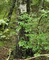
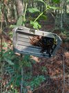
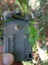
anyways for my question: was walking down a footpath off of hawkins bridge road, one of boyds maps calls it franks ford road? it was cool to see how the vegetation grows back in a place that has old parking areas and obviously used to be driven. i noticed an almost fully overgrown trail in one of the parking areas and decided to make my way through it, and came upon an old dried up bog looking spot with this object bolted to the tree. is it an old ccc thing, or something else? what is it even used for? i amused myself imagining it was a mailbox and a mailman having to climb through there, but that's obviously wrong haha. thanks!
anyways for my question: was walking down a footpath off of hawkins bridge road, one of boyds maps calls it franks ford road? it was cool to see how the vegetation grows back in a place that has old parking areas and obviously used to be driven. i noticed an almost fully overgrown trail in one of the parking areas and decided to make my way through it, and came upon an old dried up bog looking spot with this object bolted to the tree. is it an old ccc thing, or something else? what is it even used for? i amused myself imagining it was a mailbox and a mailman having to climb through there, but that's obviously wrong haha. thanks!


")