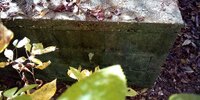
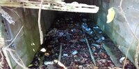
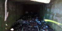
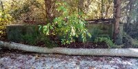
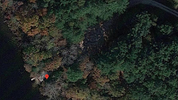
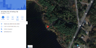
What is this? Located next to Steven's Creek, in the back of the John Estell House remains in Estellville, NJ.

EddieD

Scout
Feb 13, 2021
54
39
50
Mays Landing
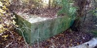
I enjoy fishing, walking, and just enjoying this area frequently. There is a rectangular concrete "box" like structure located about 15 feet in from the creek's edge and right next to the end of the gravel roadway that leads to a small delipidated old dock. It has piqued my curiosity for the last time and I must ask the question....WHAT IS IT?! LOL!

It stands about 2.5' high, maybe about 4' wide, and about 15' or 20' long. It once had a wooden, secured "door" on the front side facing the creek. The door is no longer attached, but resides next to it and is rotted out. Inside are what appear to be either two pipes or small "rails" running parallel to the length of the structure on the inside center of the floor, and are securely fastened or cemented in. Other than being filled with trash and debris, it is empty.

I thought it MIGHT have been some sort of irrigation pump house, a defunct water management equipment housing, or some sort of sewage related structure. Those are my thoughts on what it is.

If anyone knows the history of this place (I do know the history of the area, but not concerning things like this), please let me know know what it was! It is a WMA area today, maybe it's related to water treatment of the creek??

I have attached some pics of it and two Arial screen shots of its location. Thank you! Happy New Year!

Its location is 39°23'44.1"N 74°44'56.5"W according to Google Maps.​


Attachments

  • IMG_20221027_134753.jpg
    IMG_20221027_134753.jpg
    1.7 MB · Views: 144
  • IMG_20221027_134810.jpg
    IMG_20221027_134810.jpg
    1.4 MB · Views: 147
  • IMG_20221027_134857.jpg
    IMG_20221027_134857.jpg
    1 MB · Views: 148
  • IMG_20221027_134905.jpg
    IMG_20221027_134905.jpg
    674.8 KB · Views: 150
  • IMG_20221027_134924.jpg
    IMG_20221027_134924.jpg
    1.8 MB · Views: 145
  • pic.png
    pic.png
    1.4 MB · Views: 145
  • pic2.png
    pic2.png
    1.1 MB · Views: 146
  • Like
Reactions: teleflux and Boyd

Boyd

Administrator
Staff member
Site Administrator
Jul 31, 2004
9,824
3,005
Ben's Branch, Stephen Creek
Have been there but never noticed that before. There appear to be two pipes or tracks (?) that run the length of the interior. Sorry, no idea what it is. The Mapbox/Maxar imagery of that area is very clear, but I guess the trees are hiding it.

https://boydsmaps.com/#21.00/39.395546/-74.748918/mbxhybrid/0.00/0.00

BTW, the maps spell it as either "Stephens Creek" or "Stephen Creek" but don't think I've ever seen it spelled with a "v". When I moved here I registered the stephencreek.com internet domain, since it runs through my property, but I don't really use it anymore.
:)
 
Last edited:

EddieD

Scout
Feb 13, 2021
54
39
50
Mays Landing
Ha! I did'nt even realize my spelling was off on that! I guess its a case of you say tomato and I say To-mATO! LOL! Yes, the structure is underneath the trees, so looking from above you'd never see it. But I've looked with the older versions of maps, there seems to be no indication of it. Even if you walk by it, you may not see it because its semi-hidden by the trees and you'd probably be focused on looking at "STEPHEN's Creek!"

This is one of those weird NJ things again!
 
  • Like
Reactions: Boyd

EddieD

Scout
Feb 13, 2021
54
39
50
Mays Landing
Irrigation is certainly likely. Yet, I'm leaning towards the theory that it has something to do with the creek/lake management, since it is on WMA land, and the cinder block construction is likely from the 50s or 60s or even 70s (the Estell house was built WAY before that time and used Jersey Sandstone for foundation materials).
 

EddieD

Scout
Feb 13, 2021
54
39
50
Mays Landing
Martink, I never saw the pump house at Hammonton Lake, but, yes, this is my thought as well, some sort of pump house. But what is the purpose of a pump house here, unless of course it WAS in fact used for the irrigation of a local farm area as teleflux mentioned? I have not seen no pipelines or trenches leading to or from it or around the area though. Just those two strange pipes inside. Maybe they go underground and out into the lake. But nothing can be seen above ground going to a field or whatever. There is an old clearing/field located far off to the right of it (if you were facing the lake).
 
  • Like
Reactions: Boyd

EddieD

Scout
Feb 13, 2021
54
39
50
Mays Landing
LOL! Okay, I can see that it HAD to be a pump house, since the whole area was clearly farmland in the 30's thru perhaps the 70s. Now, I wander if the farmland was connected to the Estell family in anyway, since it was right behind and around the house. Thing is, I think the house stopped being lived in during the 40s or 50s.

Yes, those pipes would be a little small for irrigation, unless they were some sort of secondary pipes for the equipment. Hmmm...
 
Top