what is this location

nipsey russell

New Member
Sep 15, 2014
25
7
Philly Burbs
https://mapsengine.google.com/map/edit?mid=zLcz6Hi5RESA.kvD3zanbMEaw

this is probably just an old bog, but i wonder if anyone knows if this is private or public property or anything about it.

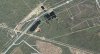
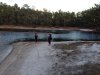
on a trip to whitesbog i noticed this on the side of rt 70 and couldn't resist pulling over. my kids had a blast running around here and it is a coolspot. a bit spoiled (my kids wanted to know why someone would need to leave 20-30 whipped cream cans laying around- "whipped cream party?"). I posted this on a facebook site and someone said "The back portion of the pond is owned by the people in the house built on the pond next to that one. The front is probably owned by the state as part of the right of way of Rt. 70. " Although i didnt see a house there, on the satellite map you can see a big pond to the south with a house there.
i have no idea (yet) how you guys created the maps on this site (awesome), but i can see the same spot on the 1930 aerial map (it oddly looks like someone used a pencil eraser on the map, thats just the shape of the water).

if we were trespassing i apologize, but we left it as we found it, were respectful, and my kids loved it.
 

bobpbx

Piney
Staff member
Oct 25, 2002
14,218
4,319
Pines; Bamber area
I've been up and down route 70 most of my adult life, and I've never been there. For some odd reason it creeps me out. Obviously man-made, maybe that's why. I don't like holes dug by people that fill with water. Don't ask me why, it just bothers me.

It likely had something to do with the construction of the bridge that used to be just west of there. There was a bridge on route 70 that crossed over the railroad.
 

RednekF350

Piney
Feb 20, 2004
4,956
3,114
Pestletown, N.J.
if we were trespassing i apologize, but we left it as we found it, were respectful, and my kids loved it.

No need to apologize to us for trespassing, save that for court. :)
I am attaching a GIS overlay of the property lines onto a 2007 aerial. The red dot marks the home of the person that owns 94 acres with the house and the rear portion of the pond. There is some ortho error in these overlays but they are fairly accurate.
The right of way of Rte. 70 in this area is tremendously large at 520' and it includes most of the pond. There was obviously a long term vision of a north and southbound highway with a median.
 

Attachments

  • rte 70Capture.JPG
    rte 70Capture.JPG
    250.7 KB · Views: 309
  • Like
Reactions: mudpie

46er

Piney
Mar 24, 2004
8,837
2,143
Coastal NJ
The right of way of Rte. 70 in this area is tremendously large at 520' and it includes most of the pond. There was obviously a long term vision of a north and southbound highway with a median.

As they are doing further west out near Marlton.
 

johnnyb

Explorer
Feb 22, 2013
474
200
96
Ooops! Ro and I were in there a few weeks back, checking to see if Bladderwort/Utricularia we'd seen there years ago was still evident. It wasn't. Obviously a party site. Didn't realize back part is private property - no way to tell that
on site. From aerial it's pretty evident lake resulted from site being a borrow pit for embankment needed to supplement 70's bridge crossing the railroad. Bet Jerseyman with his humongous knowledge of local railroads could support/deny PBX's and my supposition.
 

oji

Piney
Jan 25, 2008
2,099
484
63
Browns Mills
A large section of Rt.70 is a scenic highway. No buildings,signs and maybe power lines. That is the reason for the wide ROW. Possibly for expansion also.
 

nipsey russell

New Member
Sep 15, 2014
25
7
Philly Burbs
wow, this site is great.

So, what this means is that the front part of the ponds are "right of way" - i assume this means i am allowed to be there?

"it's pretty evident lake resulted from site being a borrow pit for embankment" - this explains the odd "pencil eraser" shape of the pond, i guess from digging machines. But i cant believe it would maintain that shape since the 30s, wouldnt it eventually even out into a more natural shape?
 

Ben Ruset

Administrator
Site Administrator
Oct 12, 2004
7,618
1,873
Monmouth County
www.benruset.com
It just means that the state owns that sliver of land. Just like whatever town you're in owns 10 feet from the street into your yard. Can you be there? Maybe/kinda/probably. Could someone give you a hard time? Yeah, probably.

The shape would stay roughly the same. There's no flowing water there. I bet it's heaven for the mosquitos.

I wonder how deep it goes? If it's only one shovel scoop deep then it doesn't seem like it'd be enough dirt to raise and lower the grade of 70 to accommodate the bridge. If it's really deep then that would also explain why it still has water in it since the 30s. But the shape of the pits don't really scream out "deep" to me.

Oh, and the whipped cream cans are from kids doing whippets to get high.
 

nipsey russell

New Member
Sep 15, 2014
25
7
Philly Burbs
Well I knew what the whipped cream was for, my kids were the ones confused, I've been around the block:eek:

And I still don't see how a bucket scoop wouldn't even out over 80 years, but ... there it is!
 
  • Like
Reactions: Ben Ruset

johnnyb

Explorer
Feb 22, 2013
474
200
96
Comparing the 1931 aerial photo with recent Google Earth view there's been considerable smoothing of the shorelines of both ponds, especially the southern/western one.....
 
Top