Does anyone have any tips on what to look for as far as finding the site where a watermill once stood? Im pretty sure you need to understand the topography of the land where you suspect a mill may have once stood . And understanding the topography will narrow down what kind of mill would have most likely been built with efficiency and height / rate of the water onto the wheel but when i walk into the woods i have no idea what im looking at ! Lol I cant tell what may have been colonial or “ early “ features like dams or possible raceways or is modern development flood prevention features. If you were going to find where a watermill once stood what would you look for? What would convince you that a mill never stood at a particular location and to move onto a different area ? Sorry in advance if these questions are stupid.

What to look for when trying to find an old watermill site
- Thread starter WestJerseyHistoryExplorer
- Start date
You are using an out of date browser. It may not display this or other websites correctly.
You should upgrade or use an alternative browser.
You should upgrade or use an alternative browser.
Old, heavy beams right next to the bank would be a clue I think. Look to see if anything is jutting out from the bank or if there is a platform actually under water. Go to Dover Forge, and you'll see what I mean. Now, clearly that's only a clue. Dover Forge also had a bridge there, so maybe I'm off base.
Hello everyone. Ive posted a while ago regarding finding the site where a mill may have once been on Otter branch in Chews Landing near Gabreil Daveis tavern. I remember there used to be a grinding stone for a gristmill on the taverns property too until it was stolen sometime around 2009. I have no idea if that millstone is related to any of the mills im looking for in Farr’s watermills of Camden County. The mills in particular are “ Porters mill & Wards sawmill . According to the book no evidence has been found for these mills at or near chews landing. But my theory is how hard did they look ? If there was a sawmill or gristmill on Otter branch , what features would you look for ? What would you need to know to be convinced no mill ever stood on a particular site ? I go into the woods with a fun plan in my head dragging my brother and sometimes my niece with me but then realize i have no idea if the “ dam “ im looking at is modern flood prevention or from something else. Or if the “ raceway “ is actually natural and where the creek used to run etc . Ive tried using the Lidar feature on Boyds maps along with infared for trying to identify old roads or trails. The area is blurred out in the Lidar. In Lidar in the pines hd youll see the area around the tavern blurred out. And its hard to identify smaller features like wooden beams without being able to zoom in closer . Im looking for tips on what to look for if anyone is interested in helping me out . Thanks ! And Sorry if this seems like they are silly questions. I think it would be awesome to discover the site of an old saw / grist mill but obviously its alot harder trying to understand and differentiate between modern and historic land features
Last edited:
Thanks for the tips ! Ive also tried using the Lidar feature on Boyds maps but , the area im trying to search in is blurred out for some reason .
Update 6/28/2023:
From my server logs, I see that people have been finding this old thread. Most of the links here reference an old website that was shut down two years ago but I have fixed them where possible. And the good news is that there's an abundance of new, high-resolution LIDAR imagery available on my new site(s). Start from the link below and click the map menu at the top right corner. You'll see all the LIDAR maps towards the top the menu. The ones in blue are three-dimensional maps where you can tilt and rotate the map for a more realistic view. Below those you will find two-dimensional versions of the same maps - these load faster and use less data if you don't want 3d views. These maps are all compatible with computers as well as phones, where you can also install the site as an app on your home screen and use it like a GPS.
https://boydsmaps.com/#16.00/39.835890/-75.057020/mbx3dmidatl/0.00/0.00
Even better, if you find a location that interests you on the map, click the button with a cube icon to open the 3d terrain viewer. This will launch another app with a number of controls that allow you to explore the terrain in much greater detail than ever before (this feature is not available on a phone, however).
Also note that LIDAR imagery is now available for the entire US Mid-Atlantic region and not only the Pine Barrens. Coverage will expand to an even larger area later in 2023.
My maps use the data that was available at the time. The "blurry" stuff has a resolution of 3-meters/per pixel. In other words, every little dot in that image represents a 3 x 3 meter (10 x 10 feet) square on the ground. The sharper imagery has a resolution of 1-meter (3' - 3") per pixel. While it might seem like there isn't much difference between 1 and 3, we are talking about a "squared function". So, where the low resolution imagery only has one little dot, there are 9 little dots (3 x 3) representing the same thing on the high resolution LIDAR. That's a huge difference and it reveals much more detail.
The good news is that NJ just released high resolution imagery for all of Southern NJ within the past couple weeks. But the bad news is that I won't have time to make any maps from it for awhile.
From my server logs, I see that people have been finding this old thread. Most of the links here reference an old website that was shut down two years ago but I have fixed them where possible. And the good news is that there's an abundance of new, high-resolution LIDAR imagery available on my new site(s). Start from the link below and click the map menu at the top right corner. You'll see all the LIDAR maps towards the top the menu. The ones in blue are three-dimensional maps where you can tilt and rotate the map for a more realistic view. Below those you will find two-dimensional versions of the same maps - these load faster and use less data if you don't want 3d views. These maps are all compatible with computers as well as phones, where you can also install the site as an app on your home screen and use it like a GPS.
https://boydsmaps.com/#16.00/39.835890/-75.057020/mbx3dmidatl/0.00/0.00
Even better, if you find a location that interests you on the map, click the button with a cube icon to open the 3d terrain viewer. This will launch another app with a number of controls that allow you to explore the terrain in much greater detail than ever before (this feature is not available on a phone, however).
Also note that LIDAR imagery is now available for the entire US Mid-Atlantic region and not only the Pine Barrens. Coverage will expand to an even larger area later in 2023.
Last edited:
@WestJerseyHistoryExplorer - I have split some posts from your other thread and merged them here. No big deal, but in the future please don't post the same thing in multiple threads. It just gets confusing when people respond separately to the different threads. Thanks!
Sorry about that ! Wont happen again. Thanks for letting me know about the lidar data issue . I couldn’t figure out why that area would be blurred . The only thing i came up with was theres an archaeological grid in that area from the NJ arcgis website . I thought maybe it was for site protection. I never thought of just no lidar data points being available lol

Great questions. Finding old mill sites is one of my favorite past times. I don't have much time now to respond, but I believe the mill dam was here: https://boydsmaps.com/#19/39.83654/-75.05951/njgin1930
And here is the raceway:
https://boydsmaps.com/#19/39.83589/-75.05702/lidarHD
And here is the raceway:
https://boydsmaps.com/#19/39.83589/-75.05702/lidarHD
Last edited by a moderator:
I could be off, of course. This is just a guess after having only had a few minutes to look at the lidar.
Sorry about that ! Wont happen again.
Certainly no need to apologize! FWIW, this was all the high-res LIDAR that was available until just a few weeks ago.

There was actually a bit less available when I made that map. Note the "Swiss cheese holes".

Pineypaddler thanks for your input and time ! Ive talked about this topic with Sharon Mickle who gives the tours at the tavern and has been involved with saving the moffa farm house . She told me she believes it was in the same location you place the races and dam . You can see another earthwork portruding from the bank thats pointing at the white farm house on bee lane. Ive read that was the remains of the earthen dam. I will have to check that area out better at low tide in my kayak when it warms up . Boyd , thank you for the amazing maps and replies ! I use your maps when im at my house in Fortescue to locate where the old piers were for finding spots to cast fishing and metal detecting.
West Jersey History Explorer:
Your search for the sawmill has sparked my interest. During your fieldwork, you should concentrate your investigation on the mouth of Otter Branch, because a 1724 court order for clarifying the boundary between Gloucester and Newton townships refers to this stream as "Samuel Ward's Mill Creek." In January 1717, the New Jersey Colonial Assembly passed an act to raise revenue through taxation. This is the only early tax act found that lists individual sawmills and gristmills by county and Samuel Ward's name is not enumerated within the law, suggesting that Ward established his mill sometime between 1717 and 1724. It is likely that Ward located his mill at or proximate to the mouth of Otter Branch since the topography of the land leading to the mouth is a rather deep ravine—ideal for creating a millpond. Since Ward's 1729 will fails to mention the sawmill in its covenants or the associated inventory (stock of lumber), Ward likely had ceased milling operations there prior to his death. Perhaps a freshet wiped out the dam.
In 1756, Gabriel Davis constructed his tavern at the top of the bluff overlooking the North Branch of Big Timber Creek. To facilitate access to the tavern and the landing, Davis constructed the floodgates dam. Since he built the dam just above the head of tide, Davis's project did not require a legislative act. The floodgates dam prevented the flow of water up the branch beyond the dam, thereby allowing the farmers along the waterway to maintain their meadows. The dam included a gated sluice bypass that allowed for repairing the dam. Some documents mention "sheeting" adjacent to the dam. This installation of timber prevented the creek bottom from being scoured. The detail below from the 1777 road map shows both the dam and the sluiceway:

The sluiceway at the dam should not be construed as a millrace, so the location previously identified in this thread is incorrect.
The next potential sawmill to occupy the mouth of Otter Branch belonged to Nicholson & Troth, 1816-1818, although it is unclear whether it ever actually operated. Rather than repeat what Bill Farr wrote about the mill, I will direct all readers here: http://www.westjerseyhistory.org/books/farrwatermills/N.shtml
Some judicious digging might reveal remains of the dam and/or the mill foundation, but the construction of the Floodgates Road Bridge (now a ruin) over the mouth of Otter Branch and the widening of Somerdale Road might have destroyed the evidence of the dams and mills.
Best regards,
Jerseyman
Your search for the sawmill has sparked my interest. During your fieldwork, you should concentrate your investigation on the mouth of Otter Branch, because a 1724 court order for clarifying the boundary between Gloucester and Newton townships refers to this stream as "Samuel Ward's Mill Creek." In January 1717, the New Jersey Colonial Assembly passed an act to raise revenue through taxation. This is the only early tax act found that lists individual sawmills and gristmills by county and Samuel Ward's name is not enumerated within the law, suggesting that Ward established his mill sometime between 1717 and 1724. It is likely that Ward located his mill at or proximate to the mouth of Otter Branch since the topography of the land leading to the mouth is a rather deep ravine—ideal for creating a millpond. Since Ward's 1729 will fails to mention the sawmill in its covenants or the associated inventory (stock of lumber), Ward likely had ceased milling operations there prior to his death. Perhaps a freshet wiped out the dam.
In 1756, Gabriel Davis constructed his tavern at the top of the bluff overlooking the North Branch of Big Timber Creek. To facilitate access to the tavern and the landing, Davis constructed the floodgates dam. Since he built the dam just above the head of tide, Davis's project did not require a legislative act. The floodgates dam prevented the flow of water up the branch beyond the dam, thereby allowing the farmers along the waterway to maintain their meadows. The dam included a gated sluice bypass that allowed for repairing the dam. Some documents mention "sheeting" adjacent to the dam. This installation of timber prevented the creek bottom from being scoured. The detail below from the 1777 road map shows both the dam and the sluiceway:
The sluiceway at the dam should not be construed as a millrace, so the location previously identified in this thread is incorrect.
The next potential sawmill to occupy the mouth of Otter Branch belonged to Nicholson & Troth, 1816-1818, although it is unclear whether it ever actually operated. Rather than repeat what Bill Farr wrote about the mill, I will direct all readers here: http://www.westjerseyhistory.org/books/farrwatermills/N.shtml
Some judicious digging might reveal remains of the dam and/or the mill foundation, but the construction of the Floodgates Road Bridge (now a ruin) over the mouth of Otter Branch and the widening of Somerdale Road might have destroyed the evidence of the dams and mills.
Best regards,
Jerseyman
So good to see you post again, Jerseyman! Great info as always. Evidently, the mill dam was not in the same location as the old Floodgates Road Bridge. There does appear on Lidar what looks to be an old road or possibly a dam just a short distance upstream from the old bridge: https://online.boydsmaps.com/#18/39.83768/-75.05812/lidarHD
I hope to get out there soon to do some ground-truthing. My curiosity has been piqued.
I hope to get out there soon to do some ground-truthing. My curiosity has been piqued.
Gabe:
Excellent observation on the Lidar HD mapping! I could not agree more that the stub of the dam still appears in the landscape just up Otter Branch from the floodplain. The placement is perfect for placing the sawmill down on the floodplain for ease of timber and sawn lumber handling relative to rafts and flatboats on Big Timber Creek.
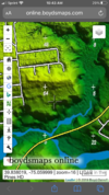
I apologize you found the unannotated map confusing. I hope you find this version more helpful:

Best regards,
Jerseyman
Excellent observation on the Lidar HD mapping! I could not agree more that the stub of the dam still appears in the landscape just up Otter Branch from the floodplain. The placement is perfect for placing the sawmill down on the floodplain for ease of timber and sawn lumber handling relative to rafts and flatboats on Big Timber Creek.
I apologize you found the unannotated map confusing. I hope you find this version more helpful:
Best regards,
Jerseyman
Gabe:
Excellent observation on the Lidar HD mapping! I could not agree more that the stub of the dam still appears in the landscape just up Otter Branch from the floodplain. The placement is perfect for placing the sawmill down on the floodplain for ease of timber and sawn lumber handling relative to rafts and flatboats on Big Timber Creek.
I apologize you found the unannotated map confusing. I hope you find this version more helpful:
View attachment 14551
Best regards,
Jerseyman
Very helpful! Thanks, Jerseyman. I'll do a thorough exploration in the near future and will report back.
Jerseyman,
I'm guessing that Chew's Landing (the landing itself) was located where the American Legion is currently situated. Can you confirm?
I'm guessing that Chew's Landing (the landing itself) was located where the American Legion is currently situated. Can you confirm?
Gabe:
Yes, you are correct about the landing's location.
Best regards,
Jerseyman
Yes, you are correct about the landing's location.
Best regards,
Jerseyman
By the way, WJHE, it is amazing what does survive the passage of time. I could take you to see the location of a sawmill that ceased operations in 1726 in the Haddonfield-Cherry Hill area and a segment of the dam remains extant, along with a scour bowl in the embankment behind the dam caused by the dam being breached by a large freshet after operations ceased. It is an amazing sight and site in 21st-century suburban Camden County!
Best regards,
Jerseyman
Best regards,
Jerseyman