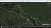
Since you all live out there, I don't fully understand this, so please forgive this dumb question. If the state owns lot A and B, couldn't they just put a new road in right next to his, like the red line below?


Closing West Mill Road
- Thread starter Broke Jeep Joe
- Start date
You are using an out of date browser. It may not display this or other websites correctly.
You should upgrade or use an alternative browser.
You should upgrade or use an alternative browser.

Guy
I could have swore the road stayed outside of (to the north) of the state monuments.I am going to have to see if i can find my files but I thought the northern most road was entirely on tstae property?
I could have swore the road stayed outside of (to the north) of the state monuments.I am going to have to see if i can find my files but I thought the northern most road was entirely on tstae property?
As you can see from the open space overlay which may not be 100% accurate and from my stone GPX file which is accurate the raod passes above the Paradise Lakes exception. The state needs to get a surveyor out there and then take the guy to court and tell him to get his crap off their road before they sue him to hell and back.Guy
I could have swore the road stayed outside of (to the north) of the state monuments.I am going to have to see if i can find my files but I thought the northern most road was entirely on state property?
PS
even the exception overlay shows and exception to the exception for the southern road but the northern road completely misses the Paradise property.Go pound sand double time Paradise!
Attachments
A question. Has anyone tried coming in from the other direction to see where or if He has gated the road from that way as well?
As you can see from the open space overlay which may not be 100% accurate
If that's my openspace .kmz file, then it isn't very accurate in most cases. My HD Map of the Pines is much better and is based on parcels instead of the state's openspace dataset. When working on that map I actually read this thread and hand-traced all the roads I could see on the aerials. I'm sure there are still plenty of errors though.
")
Here's the map that I posted before: http://boydsmaps.com/download/whartonHD.zip
I spoke to someone who has seen trees felled to block access from a road that comes over from Rockwood. I don't know what you would encounter coming from the east along West Mill itself.A question. Has anyone tried coming in from the other direction to see where or if He has gated the road from that way as well?
are they still running a campground at paradise lakes or is someone living back there? Last time I was back there there were a few hippies in a tent.They didn't see me.
Boyd
Your map shows the southern road and it is an exception running through the exception or perhaps i should say an easement running through it but your map does not show the northern route which completely over shoots the Paradise lakes exception.Guy and I have both been to the stones marking the Paradise exception and they are south of the northern road and it does not cross the Paradise property at any point.The guy is shutting down public property.He obviously does not read maps or know where his own corners are.Or maybe He's just a bunghole.
Your map shows the southern road and it is an exception running through the exception or perhaps i should say an easement running through it but your map does not show the northern route which completely over shoots the Paradise lakes exception.Guy and I have both been to the stones marking the Paradise exception and they are south of the northern road and it does not cross the Paradise property at any point.The guy is shutting down public property.He obviously does not read maps or know where his own corners are.Or maybe He's just a bunghole.
The primary reason for such a discrepancy between the property line mappings provided by various governmental sources and the real life locations of boundary lines in the field is that the mappings are only based on municipal tax maps. The State's online boundary mapping sources are just a collection of all municipal tax maps . Tax maps are an amalgam of plottings of deeds and surveys collected by the assessors and municipal surveyors and engineers over the years.
I can tell you from my 28 years in practice of preparing and signing municipal tax maps that no attempt is ever made to rectify disagreements between deeds or other pieces of information by performing fieldwork. In an area such as Paradise Lakes, deed descriptions are recylcled over and over between successive owners and have never been verified through a complete boundary survey. Some older deed descriptions have huge errors in closure meaning that they do not form a closed geometric figure when mapped. Some legal descriptions are very weak too where a property may only be described by a block and lot in which case an accurate mapping is nearly impossible.
The last resort in preparing tax maps is to show distances on a tax map as (s) which means the distance was scaled which introduces even more mapping error.
His property does not cross the road.
Yes, you proved that, but that's not my point. It seems to me there is an impasse, and nobody (state or township) is doing the a deep dive to survey the property and bring that to the courts. And the public is not raising enough of a fuss to prompt them to do it.
Does anyone on this forum know something the rest of us don't? Is there something being worked behind the scenes?
I know it would not really happen (maybe), but if the state plowed a road beginning 1 foot north of his, and declared it open, I doubt if Miller would even challenge it. If he wanted to, he'd have to conduct a proper survey to prove it.
The FFS can create a road quickly. They've done it before, and this time they can justify it.
Done. Problem solved.
The State's online boundary mapping sources are just a collection of all municipal tax maps . Tax maps are an amalgam of plottings of deeds and surveys collected by the assessors and municipal surveyors and engineers over the years.
So the deed the owner has may show him as owner of the property and the state really has nothing tangible to show? I doubt this guy would build another gate for haha's; someone must have told him it would stand the test. This may go on for some time until some judge comes to a decision. Then the appeals begin.
So the deed the owner has may show him as owner of the property and the state really has nothing tangible to show? I doubt this guy would build another gate for haha's; someone must have told him it would stand the test. This may go on for some time until some judge comes to a decision. Then the appeals begin.
I can say with confidence that the owner does not know where his corners are located. I can also say with confidence that he is displaying all of his testicular fortitude based on the license agreement to control the road for which he paid Hammonton $5,000.00.
You are correct in saying that this will go on "for some time" .
Yes, you proved that, but that's not my point. It seems to me there is an impasse, and nobody (state or township) is doing the a deep dive to survey the property and bring that to the courts. And the public is not raising enough of a fuss to prompt them to do it.
Does anyone on this forum know something the rest of us don't? Is there something being worked behind the scenes?
I know it would not really happen (maybe), but if the state plowed a road beginning 1 foot north of his, and declared it open, I doubt if Miller would even challenge it. If he wanted to, he'd have to conduct a proper survey to prove it.
The FFS can create a road quickly. They've done it before, and this time they can justify it.
Done. Problem solved.
There is no need to plow a road when there is a perfectly, well maybe, good road there already that the state needs to get open. If you build a road around it he has won. I don't like people to win when they are holding that property hostage.
There is no need to plow a road when there is a perfectly, well maybe, good road there already that the state needs to get open. If you build a road around it he has won. I don't like people to win when they are holding that property hostage.
Petition the state to move on it? The petition should request what the state's stance is on it as well.
Guy or I can show Him where his corners are located.All He has to do is ask.I for one would do it for free just to have the opportunity to see him have to admit his ignorance and put an end to this charade.I can say with confidence that the owner does not know where his corners are located. I can also say with confidence that he is displaying all of his testicular fortitude based on the license agreement to control the road for which he paid Hammonton $5,000.00.
You are correct in saying that this will go on "for some time" .
Guy or I can show Him where his corners are located.All He has to do is ask.I for one would do it for free just to have the opportunity to see him have to admit his ignorance and put an end to this charade.
I have no stake in this but if shown the stones I'd say he'd then move them to his advantage. The State or the property owner is going to have to hire a survey team to prove once and for all the property lines. I've seen in one instance where "established" property lines were moved approximately 600' North and 300' West. In this instance I'm talking about Haines & Haines now PICC.
I have no stake in this but if shown the stones I'd say he'd then move them to his advantage. The State or the property owner is going to have to hire a survey team to prove once and for all the property lines. I've seen in one instance where "established" property lines were moved approximately 600' North and 300' West. In this instance I'm talking about Haines & Haines now PICC.
I agree that there needs to be a surveyor hired to settle this. I also believe that the party who arguing against the state should pay for it. He evidently has money to burn with moving the gates so quickly. I think he would want to pay for it to prove it is rightfully his but my guess is he knows the state will not move on getting their own too quickly because of the governor's race and all the changes that will come with that.
The point here is not his property lines it is the fact that the town of Hammonton vacated the road to him. If the state can't turn that around the road is his.